This post is based primarily on
Don's notes, occasionally supplemented with MT's notes from our Camino in 2016.
When information from other sources is added—for further explanation to readers
or to satisfy our own curiosity—that is set off in a text box (as this one).
Most of the photos that accompany
this post are from Don’s camera (with a caption indicating the time it was
taken); those from MT’s iPhone are indicated by “MT” placed at the beginning of
the photo caption. Photos from any other source (such as the public domain
Wikimedia Commons) indicate that source in the caption.
We
departed at 9:10. The receptionist told us about a new path (only 8 months old) along the Rio Minho all the way to
Valença; she said there would be no arrows, but to just follow the paved path,
painted pink or yellow. She said the old way was on highways and secondary
roads and very dangerous. Don missed having the route go through villages (the
new way had no towns or bars for banho
breaks until near the end), but this way was flat and easier going.
We
had to rely on MT’s iPhone to take photos, since Don’s camera had broken the
evening before. (Although photo captions indicate “MT” for MT’s iPhone, both of
us took photos with it.)

MT Monday, September 19, 2016, 9:13M – after Vila Nova de Cerveira: pink
paved path along Rio Minho.
Soon,
the path along the river passed near the village of Lovelhe.
Lovelhe (previously
called Lobelhe) already existed at the time of the Roman occupation of the
Iberian Peninsula, and its name derives from the Roman name Lubelius. Lovelhe
was already a freguesia (civil
parish) in 675, making it one of the oldest parishes in Portugal. In 2013, the
Freguesia de Lovelhe (pop. 443 in 2011) in the municipality of Vila Nova de
Cerveira was merged in 2013 into the Freguesia de Vila Nova de Cerveira e
Lovelhe as part of an administrative reorganization.

MT 9:29 AM - Lovelhe: Forte de São Francisco de
Lovelhe- two bastions with round guard towers; road sign pointing to right to
village of Lovelhe.
Also in the Freguesia de Vila
Nova de Cerveira e Lovelhe is the Forte
de São Francisco de Lovelhe (Fort of St. Francis of Lovelhe), also known as
Forte de Azevedo or simply as Forte de Lovelhe (Fort of Lovelhe).
This fortification dates back to the time of the Wars of Restoration
(1640-1668), when the Governador das Armas do Minho (Governor of the Defenses
of the Minho) ordered this fort to be built, to resist Spanish attempts to
reunite the Iberian Peninsula. It was part of the defensive line on the left
(south) bank of the Rio Minho. Its construction was begun in 1642, under the
direction of General Dom Francisco de Azevedo, who was also an engineer, and
completed in 1663. Despite its smaller size, it had greater potential for
defense than the fortification of Vila Nova de Cerveira. By 1758, almost a
century after the Wars of Restoration, the fort was without soldiers and would
serve as a cattle shelter. The fort was rebuilt in 1797 and about a decade
later played an important role in the active defense of the region against the
invasions of Napoleonic troops. During that Peninsular War, much of its inner
premises were blown up by French troops in 1809. Although it lost its military
function in the 19th century, it served as a hospital during an epidemic in
1857. Since then it has been abandoned.

Lovelhe: Forte de São
Francisco de Lovelhe
(https://pt.wikipedia.org/wiki/Forte_de_S%C3%A3o_Francisco_de_Lovelhe#/media/File:Forte_de_Lovelhe2.jpg by Adrián
Estévez (Estevoaei). Original uploader was Estevoaei at gl.wikipedia -
Transferred from gl.wikipedia(Original text : self made), CC BY-SA 3.0, https://commons.wikimedia.org/w/index.php?curid=7400985 ).
Built according to typical
17th-century military architectural models, the fort has a pentagonal (star)
shape, consisting of five bastions—four of equal dimensions arranged laterally,
two by two, and a fifth, larger one built on the front wall by the porta de armas [door of the coat of
arms?]. Round guard towers were arranged at each of the corners of the
ramparts.
Around
10:15, Don had to make a stop in a cornfield.

MT 10:43 AM - Parque Lazer da Lenta: sign for
“EcoPista caminho do rio [way of the river] Vila Nova de Cerveira cerveira sandável”
with red “You are here!” circle indicating that this was at “Parque de Lazer da
Lenta (Lenta Park [of Leisure])” and showing that the pink path changes to
yellow at this point.

MT 10:45 AM – After Parque Lazer da Lenta: yellow
paved path by river.
At
11:00, Don had to make another stop in tall weeds by round hay bales covered
with plastic.

MT 11:23 AM – Furna: another sign for EcoPista
yellow paved path by river, with red “You are here!” circle indicating that
this was at “Furna.”

MT 11:39 AM – After Furna: small boat on Rio Minho.

MT Monday, September 20, 2016, 11:47 AM – After Furna: sign beside yellow paved
path forbidding bicycles (or motorcycles?), cars, and horse-drawn carts.

MT 11:47 AM – After Furna: same sign beside yellow
paved path forbidding bicycles (or motorcycles?), cars, and horse-drawn carts;
however, pedestrians and bicycle painted on the path itself indicate that
bicycles are allowed.

MT 12:17 PM – After Furna: yellow path (with
pedestrians and bicycles painted on it) gives way to pink path.

MT 12:36 PM – São Pedro da Torre: another EcoPista
sign, this one with the red circle for “Você está aquí!” (You are here!) at
Pesqueira de São Pedro da Torre (pesqueira
= place for fishing); this map shows the “green” route continuing to a Ponte
Romana (Roman Bridge) at Veiga da Mira, then going back to the riverside around
Cristelo Côvo, then turning right (east) at Parque da Senhora da Cabeça, then
left (north) and skirting the west side of the Fortaleza de Valença to the
Ponte Internacional (International Bridge), where we would cross into Spain;
after that bridge, the “green” route continues on the Portuguese side of the
river.
São
Pedro da Torre
(St. Peter of the Tower) is a freguesia
(civil parish, pop. 1,267) in the municipality of Valença.
The
Freixo maps did show an alternate
“green” route labeled Senda Fluvial (River Trail) along the river for a short
distance after Vila Nova de Cerveira (about 7 km) but then going back to the “old”
inland way until around Cristelo Côvo, about 12.5 km after Vila Nova de
Cerveira, where the “green” route again branched off to the river until turning
sharply inland on Avenida Santa Maria da Cabeza to enter the south gate of the Fortaleza
de Valença.

MT 11:56 AM – Veiga da Mira: Roman bridge.
Veiga
da Mira
is a natural zone along the left bank of the Rio Minho, crossing the freguesias (civil parishes) of São Pedro
da Torre and Cristelo Côvo. It is characterized by an extensive veiga (plain), flooded, where forest
vegetation predominates.

MT 11:57 AM – Veiga da Mira: Roman bridge – surface
of roadway.

MT 11:58 AM – Veiga da Mira: after Roman bridge,
pink path with yellow arrow painted on wooden post and another on leg of metal
tower.

MT 1:37 PM – Veiga da Mira: sign for “Nome do
Percurso: Trilho Veiga da Mira; Localização: Cristelo Côvo e S. Pedro da Torre;
Tipo de Percurso: Pequena Rota (PR)” [Name of Route: Veiga da Mira Trail; Location:
Cristelo Côvo and S. Pedro da Torre; Type of Route: Small Route (PR)].
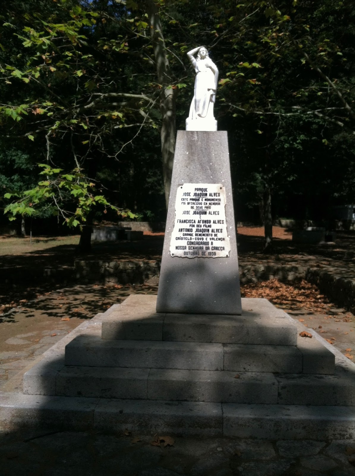
MT 1:41 PM – After Veiga da Mira: statue of Nossa
Senhora da Cabeça (with the Virgin holding the top of her head); plaque on base
reads: “Parque José Joaquin Alves – Este parque e monumento foi oferecido en
memoria de seus pais – José Joaquin Alves e Francisca Afonso Alves por seu
filho Antonio Joaquin Alves grande bememeríto de Cristelo-Covo e Valença –
Consagrado a Nossa Senhora da Cabeça – Outubro de 1959” (José Joaquin Alves
Park – This park and monument was offered in memory of his parents – José
Joaquin Alves and Francisca Afonso Alves by their son Antonio Joaquin Alves [grande
bememeríto=?] of Cristelo-Covo and Valença – Consecrated to Our Lady of the
Head – October 1959).

MT 1:42 PM – Parque Senhora da Cabeça: Bar Senhora
da Cabeça, near picnic bench.
Around 1:42 pm, we stopped at Bar Senhora da Cabeça (Lady of the
Head) for two glasses of red wine and cheese on bread (total €5.20).We got carimbo stamps.

Parque Senhora da Cabeça: carimbo stamp from “Bar SR.a
da Cabeça, María Isabel Ferreira Simões, N.I.F. PT [Número de Identificação
Fiscal – tax identification number, Portugal]… Parque SR.a da Cabeça
4930 Valença.”
The Parque Natural da Senhora da Cabeça ([Our] Lady of the Head Natural
Park), also known simply as Parque
Senhora da Cabeça ([Our] Lady of the Head Park) or as Área de Lazer de Nossa Senhora da Cabeça (Leisure Area of Our Lady
of the Head), is a park located by the Rio Minho, in the freguesia (civil parish) of Cristelo Côvo, where the traditional
Senhora da Cabeça pilgrimage is held. It has a restaurant, gardens, playground,
bar, nautical center, and pier. It is a place reserved for recreation and picnics.
Proximity to the river, where there are two marinas—one for pleasure boats and
another for traditional boats—also promotes water sports.
The Santuário da Senhora da
Cabeça (Sanctuary of Our Lady of the Head) is a shrine situated on the banks of
the Rio Minho, on a hill that is part of a recreation and entertainment zone
known by the same name. The feast day of this saint is the second Sunday of
July.
The
Freixo map showed the “green” route
labeled Senda Fluvial (River Trail) going along the river until turning sharply
inland on Avenida Santa Maria da Cabeça to enter the south gate of the Fortaleza
de Valença. (It shows the “red” main inland Camino route going around the east
side of the fortress.) Brierley’s text and map describe the “green” route
through the fortress as “Valença Detour,” saying that one should allow 2 hours
to explore the fortress and old town and that it is a very busy place with bus
tours until 5 pm, while his “gold” main Camino route also goes around the east
side of the fortress. However, the EcoPista trail we were on would keep us
along the river, outside the west wall of the fortress.
Valença, also known as
Valença do Minho, is a city in a municipality (pop. 14,127) of the same name in
the District of Viana do Castelo. It officially became a city in 2009. It is a
walled town on the left bank of the Rio Minho, approximately 25 km from the
Atlantic Ocean.
The origins of Valença date back to
human communities that existed here in prehistoric times. In Roman times, it
was an important crossing point over the Rio Minho and was on the Roman road
Via VI (designated itinerary XIX for military use or itinerary XX for
commercial use). In the time of Caesar Augustus, the Romans began to build
small fortresses, then called castelli,
at this strategic location; one of them was called the Castellum of Valença.
When the Romans were succeeded by Suevi (Swabians) and Visigoths, this was
still a strategic location. When the Moors invaded, for the first time in 716,
the inhabitants of Valença were forced to disperse to the north; the most
powerful Arab invasion was in 997. With the Christian Reconquest, this region
was recovered, being later integrated into the Condado Portucalense (County of
Portucale) and later into the Kingdom of Portugal. Also in this time, the old
Roman road gained importance as a route of pilgrimage to Santiago de
Compostela. During the 12th century, King Sancho I of Portugal decided to erect
a permanent defensive fortress here, ordered this stronghold to be populated,
and granted its first foral
(charter). It was then called Contrasta, which means “village opposed to
another,” referring to Tui in Spain. In 1262, King Afonso III granted it a new foral and changed its name to Valença,
trying symbolically to revive the dynamism of this strategic location. Its
historical importance is mainly due to its decisive role in the defense of
Portugal against neighboring Spain.
We
continued around the west and north side of the Fortaleza de Valença (Fortress of Valença), totally missing the
city by approaching from the riverside.
The Fortaleza
de Valença (Fortress of Valença) looks down on the Rio Minho and Spain.
Fortifications here were destroyed many times, whether by the Barbarians, the
Moors, the (Spanish) armies of Asturias and León, or even by French forces in
the early 19th century. However, they were always restored and are still well
preserved. Valença’s fortress is a piece of Gothic and Baroque military
architecture. The first walls were built in the 13th century. It was upgraded
during the 17th and 18th centuries, forming the present bulwark system with 5
km of walls, 10 bastions, and 2 half bastions. It is located on top of two small
hills and formed by two polygons (the Recinto Magistral and the Coroada) separated
by a ditch and with four gates (Coroada, Gaviarra, Fonte da Vila, and Sol). The
main entrance is Porta do Sol (Gate of the Sun), which was damaged during the
Napoleonic invasions. Located inside the fortress is a Roman milestone that
dates back to around 47 AD.

MT 2:16 PM – Valença: Fortaleza de Valença and part
of city with church tower on horizon.

MT 2:18 PM – Valença: Fortaleza de Valença wall and
two guard towers at top of embankment.

MT 2:21 PM – Valença: part of city with several
church towers beyond Fortaleza de Valença wall and guard tower at top of
embankment.

MT 2:23 PM – Valença: part of city and more of Fortaleza
de Valença wall around curve in pink path.

MT 2:25 PM – Valença: more of Fortaleza de Valença
wall and guard towers around curve in pink path.

MT 2:32 PM – Valença: more of Fortaleza de Valença
wall and guard tower.
Finally,
we arrived at the Ponte Internacional,
where we would cross into Spain.

MT 2:33 PM – Valença: another EcoPista sign with
red circle for “Você está aquí!” (You are here!) at Ponte Internacional at
north end of Fortaleza de Valença. Callout 2 for “Ponte Internacional” says:
“Rodo ferroviária, inicio do construção 1882, inaugurada a 25 de Março 1886,
projectada pela Arqa espanhol Pelayo Mancebo” (Road railway, start
of construction 1882, inaugurated March 25, 1886, planned by the Spanish
architect Pelayo Mancebo).
The Ponte Rodo-Ferroviaria de Valença (Road-Railway Bridge of Valença)
is also known as Ponte de Valença (Bridge of Valença) or Puente de Tuy (Bridge
of Tui [in Spanish]) or Ponte Internacional de Tui (International Bridge of
Tui) or Ponte Internacional Tui-Valença (Tui-Valença International Bridge) or
just Ponte Internacional (in
Portuguese or Galego [Galician] or Puente Internacional in Spanish). It is a
railroad infrastructure that crosses the Rio Minho, on the border between
Portugal and Spain. In connects the two cities of Valença (Portugal) and Tui
(Spain). The 318-meter-long bridge has a metal-beam superstructure with five
continuous sections. It has two decks, the upper for railway and the lower for
road use (with a pedestrian walkway on the side). The central span is 170
meters long. Construction began in 1882 and was completed in 1884, although it
was inaugurated with a grand opening on March 25, 1886. It was designed by the
Spanish architect Pelayo Mancebo y Ágreda, with the construction work carried
out by a Belgian firm and construction costs being divided between the
Portuguese and Spanish governments.
It is sometimes erroneously called
Ponte Eiffel de Valença (Eiffel Bridge of Valença); although the architect
Gustave Eiffel (of tower fame) was one of seven candidates who submitted
proposals for the project, his was not adopted. However, the chosen design of
Mancebo may have been inspired by Eiffel.

MT 2:35 PM – Valença: selfie of MT and Don at
Portuguese end of Ponte Internacional.

MT 2:35 PM – Valença: sign at Portuguese end of Ponte
Internacional, showing the upper deck, for railroad, leading across to Tui.

MT 2:36 PM – Valença: lower deck of Ponte
Internacional, with pedestrian walkway, leading across to Tui.

MT 2:40 PM – Tui: Don at Spanish end of Ponte
Internacional.
NOTE: Although
Brierley’s guidebook had pointed out that the time in Spain is one hour ahead
of Portugal, we unfortunately forgot to
set our watches ahead when we crossed into Spain. We did not figure this
out until Tuesday morning; then it explained some strange time-related turns of
events the rest of Monday.

MT 2:43 PM – Tui: Sign for entering “Provincia de
Pontevedra” (Province of Pontevedra) in “Comunidad de Galicia” (Community of
Galicia), with Galicia’s coat of arms.
Galicia (Galiza
in the local Galego language) is a comunidad
autonóma (autonomous community, comunidade
autónoma in Galego, the highest level of political and administrative
division in Spain), that contains 4 provinces. Since the 13th century, the coat
of arms of Galicia has a golden chalice on a field of blue. This symbol
originated due to the phonetic similarity between the words “chalice” (cáliz in Spanish or Galego, cálice in Portuguese) and Galyce
(“Galicia” in the old Norman language). Centuries later, a field of crosses was
added to the blue background, and even later also a silver host above the
chalice. The crown above the shield comes from a time when the Kingdom of
Galicia was a separate monarchy.

Coat of arms
of Galicia
#/media/File:Escudo_de_Galicia_2.svg)
The mountains of
Galicia are the first object in 5,000 km that the westerly winds coming off the
Atlantic hit; so there is an immediate change in weather with frequent rain
showers and thunderstorms and thick mountain fog—reminiscent of other Celtic
lands, particularly the west of Ireland. Galicia is Spain’s greenest region.
Galicia and its people retain many traces of the Celts, who swept through from
900-600 BC and did not relinquish their hold on this land until the arrival of
the Romans in 137 BC. The name Galicia derives from the Latin Callaecia,
later Gallaecia, related to the name of an ancient Celtic tribe that
resided here and coexisted with the Romans for 3 centuries, the golden age of
Celtic culture. The Romans called these people Gallaeci and then applied
their name to all the other tribes in the northwest who spoke the same language
and lived the same lifestyle. The Celtic character of this land is evident in
the Galicians’ favorite traditional instrument, the bagpipes.
Hundreds of ruined
hilltop castras [Spanish: castros], or fortified Celtic
settlements, survive. Even before the Celtic centuries, the native people lived
in pallozas, conical-shaped stone houses with thatched roofs. Galicia’s
population remains overwhelmingly rural; 3 out of 10 Galician families live off
the land, the highest proportion of any European region. Galicians are also
renowned for their belief in magic, witches, and superstition. In many cases,
this pagan belief in the spirit world has grafted itself onto Christianity.
Isolated from the
rest of Spain by a bulwark of mountains on the east and south, Galicia remained
relatively free from Muslim influence. As the Muslim invaders consolidated
their conquests in the south of the Iberian Peninsula, Galicia constituted a
political unit within the medieval kingdoms of Asturias and León, although it
maintained a certain autonomy that allowed it sometimes to emerge as an
independent kingdom. Galician culture showed greater affinity for Portuguese
culture than for that of Spain until the final separation of the two countries
in 1668. Galicia came under the rule of the Catholic Monarchs (Ferdinand and
Isabella), who established the Junta of the Kingdom of Galicia in 1495.
By that time, Galicia had firm economic and religious ties to the central
kingdom (Spain) because of the importance of Santiago de Compostela as a
pilgrim destination.
A regional herd of
a million dairy and beef cattle provide superb meat and milk; the latter is
used to make farmhouse cheeses such as the semi-soft breast-shaped queixo
tetilla. Beside tapas, seafood is a particular delight: pulpo a Gallego
(tender octopus), pulpo a feira (boiled or broiled octopus), and
scallops are famed. Those savory fish and meat pies called empenadas,
usually stuffed with salted cod or tuna although sometimes with shellfish or
pork, are native to Galicia, as is the famous lacón con grelos (cured
pork shoulder with turnip tops and chorizo sausage). The best Galician wine is
the fruity, full-bodied, white Albariño, perfect with seafood. The acidic and
slightly sparkling Ribeiro wine, the popular everyday wine of Galicia, is often
served in a ceramic bowl or up. Asturias is known for its sidra (hard
cider), served carbonated or still; but this is also common in Galicia.
Thick hot soups (caldo
gallego) and rich vegetable and meat stews are typical cuisine. Nearer to
the coast, fish dishes such as pulpo a la gallega (steamed octopus
dusted with paprika) and mariscos (shellfish) will dominate. Common
desserts are queso y membrillo (local cheese with quince jelly) and the
famous tarta de Santiago (almond cake dusted with powdered sugar
outlining the shape of the cross of Santiago). Wooden and stone granaries (hórreos)
are everywhere, for storing the local harvest (primarily corn, maíz) out
of reach of rat and rain. Galicia is very green because it rains so often.
Caldo gallego in
Spanish (or simply caldo in Galician) is literally Galician broth, a
traditional soup dish from Galicia. Ingredients include repollo (white
cabbage) or other greens [kale, verzas (collard greens), grelos,
or navizas/nabizas (sweet turnip greens)]; potatoes; white beans; and unto
(lard). Additionally, it can contain garbanzos (chickpeas), fatty pork, chorizo [sausage], ham, or bacon (compagno).
Galicia also has its own language, Galician (Gallego in Spanish or Galego in Galician). It is the westernmost of the romance
languages, having split off from Latin in the early Middle Ages (around the 9th
century). Modern Galician and its sibling, Portuguese, originated from a common
medieval ancestor, the language that developed in the old Kingdom of Galicia,
which covered the territories of modern-day Galicia, Asturias, and northern
Portugal. Therefore, Galician is closely related to Portuguese (more so than to
Spanish). During the Reconquista, in the 11th and 12th centuries,
Galicia pushed south into what is now Portugal; today, the southern dialect of
Galician is called Portuguese. Gallego was considered the elegant court
language in León as late as the 13th century. Troubadours sang Galician songs
in the great halls, and King Alfonso X used the language for his Cantigos
(Canticles) to the Virgin.
Under the Statute
of Autonomy of Galicia (1978), the Galician language is co-official with
Spanish. Signs in (and near) Galicia are most often in the Galician language
rather than Castilian Spanish. The most notable spelling differences are that X
replaces J, as in Xunta (junta) or Perexe (Pereje); R replaces L, as in praia
(playa) or praza (plaza); EI replaces E, as in cruceiro (crucero);
O replaces UE, as in porta (puerta), fonte (fuente), or ponte
(puente); Ñ replaces N, as in camiño (camino). Other differences are, o/os
(el/los), a/as (la/las), do/dos (del/de los), da/das (de
la/de las), no (en el), co (con el), unha (una), e (y),
and use of igrexa (iglesia); a logo (hasta luego). The Xunta de
Galicia once had a web site for translating Galego to Spanish or English and
vice versa: www.xunta.es/tradutor
(no longer available?); the Xunta de Galicia also has a site for translating
between Castelán (Spanish), Galego, and Portuguese at
http://tradutorgaio.xunta.gal/TradutorPublico/traducir/index.
http://tradutorgaio.xunta.gal/TradutorPublico/traducir/index.
In the 1991 census,
a massive 91% of inhabitants said they were able to speak Galego, the region's
Portuguese-like language. Galego is still the majority language in Galicia,
although there is a tendency for Spanish to gain ground in daily use. Galego
tends to be heard more in rural areas, and it is still thought of as an old
person's language. After Galicia was granted autonomous government in 1981, the
study of the language took off.
Galician music is
firmly Celtic, and perhaps nothing shows the links between northern Celtic nations
and Galicia better than the gaita (Galician bagpipe).
In Galicia,
municipios [municipalities in Spanish] are called concellos, which
break down into different parroquias [parishes] that in turn contain towns
and villages.
Pontevedra is a city (pop. 75,000) that is the
capital of both the Comarca (County) and Provincia (Province) of Pontevedra in
Galicia. It is also the capital of the municipality (pop. 82,549) of the same
name.

MT 2:44 PM – Tui: MT with sign for entering Tui.
Tui
(the
Galician name, but the official Spanish spelling is Tuy) is a city (pop. 15,000) in a municipality of the same name (pop.
17,262) in the Province of Pontevedra, located on the north bank of the Río
Miño, facing the Portuguese town of Valença. The fertile valley of the Miño
accommodated human settlement since prehistoric times. (Highway construction
has uncovered vestiges of human occupation dated from the Lower Paleolithic
period.) In the castreña period
(8th-7th centuries BC to the 1st century AD), stable and fortified settlements,
called castros (hill fortresses) were
constructed on the tops of mountains and hills. The Romanization of the area
began in 137 BC. At that time, the inhabitants of the castros began to leave the high areas and to descend to the banks
of the river. The original name, Tude, was mentioned by Pliny the Elder and
Ptolemy in the 1st century AD, who documented the existence of Castallum Tude
and the mythical foundation of the city by the Greek hero Diomedes, son of the
hero Tideo (hence the name Tude). The adjective for the city and its people is
still Tudenese (tudense in Spanish). It
became an episcopal see no later than the 6th century, during the Suevic
(Swabian) rule. After the Swabians were integrated into the Visigothic kingdom
(585), it briefly served as the capital of a Galician subkingdom. At the
beginning of the 8th century, the city of Tui was devastated during the Moorish
invasion. After the campaigns of King Alfonso of Asturias (739-757) against the
Moors, Tui was liberated in 739 and 860; however, the town lay abandoned in the
largely empty buffer zone between Moors and Christians. During the reign of
Ordoño I of Asturias (850-866), it was part of a repopulation effort. In 915, Ordoño
II restored the episcopal see. Later in the 10th century, Tui was raided and
plundered by the Vikings and abandoned, with the episcopal see vacated until
1071, when it was re-established by King García of Galicia. With the
independence of the Kingdom of Portugal in the early 12th century, Tui became
the scene of multiple border struggles over the centuries. In 1170, King
Fernando II ordered the transfer of the Tudenese population from the area of
San Bartolomeu to the current location and endowed it with a system of walls of
which several sections are still preserved. The city then began to recover its
splendor and became the capital of a province named after it in the Kingdom of
Galicia. In the medieval centuries, Tui was an important commercial center,
with a dynamic river port, and became an important stop on the pilgrimage route
to Santiago.

Tui: Coat of arms of Tui
#/media/File:Coat_of_Arms_of_Tui.svg))
The coat of arms of Tui shows the
glory and nobility of the city from very remote times in its sky blue shield;
in the left half is a silver half-moon and in the right half three gold stars.
The moon represents the population and the nobility that assists it; the stars
(from top to bottom) represent King Alfonso (who recovered Tui from the Moors),
Ordoño I (who repopulated it after the war), and Fernando II (who moved the
city to the current site). Above the shield is a golden crown.

MT 2:54 PM – Tui: crucero (cross) by gas station.

MT 2:56 PM – Tui: our first view of Cathedral on
hill.
We
entered Tui along highway N-551, on which we had crossed the International
Bridge.

MT 2:59 PM – Tui: closer view of Cathedral on hill,
from along highway.
We
passed a small park with “Monumento al Peregrino MMV” (Monument to the Pilgrim
2005).

MT 3:02 PM – Tui: MT at Monumento al Peregrino with
statue of Santiago Peregrino; “Agua No Potable” (Water Not Potable) by fountain.

MT 3:03 PM – Tui: Don at Monumento al Peregrino
with statue of Santiago Peregrino; “Agua No Potable” (Water Not Potable) by
fountain.
On
the way to our hotel, MT stopped at two peluquerias
(hair dressers’ salons) to inquire
about a haircut;
the first place wanted only €20 but couldn’t get to her until the next day, and
the second, KM Peluqueria, was €26 and could take her that afternoon. So she
made an appointment for 4 pm to allow time to shower at the hotel.
We arrived at Hotel Colón (3-star) at what we thought was around 2:30 pm (it was
actually 3:30). We got stamps (now called sellos
in Spanish) for our credenciales.

Tui: sello stamp from “Hotel Colon Tuy, S.L.”
S.L. or SL stands for sociedad limitada, similar to British
Ltd. (limited) or the American LLC (limited liability company). The Spanish SL
can also stand for sociedad de
responsabilidad limitada, which literally means limited liability company
and can also be abbreviated SRL.
We
both showered and washed a few clothes and hung them in the bathroom to dry
(our room had no balcony).
Then
MT went to the hair dresser at what she thought was 4 pm (but was actually 5 pm);
the hairdresser didn’t say anything about being an hour late.
Meanwhile,
Don asked the hotel reception clerk about a place to look for a new camera, and
she sent him back toward the center of town to a store with lots of electronic
stuff; Don found that store (but on the wrong street). He found a mobile phone
store on the same street as the hotel (Rúa Colón), asked about cameras, and
they sent him back past the hotel on that street to what seemed to be a
photography studio, called Jesus
Fotografo. Don asked the man there if there was a place nearby to buy a
camera. The man, who spoke almost no English, asked if he wanted a grande (large) or pequeño (small) one. Don explained (in Spanish, the best he could)
that he needed a small digital camera and what had happened to his old camera.
The man had only one such camera on a shelf, a Nikon Colorpix S4200; he had to scan the bar code to find out how
much it cost; the computer said €135 in one column, but another column said
€108 ($120.95 at the current exchange rate), which was what he asked. (Later,
Don looked up this camera online and found one on eBay for $180; so this was a
really good deal—he must have felt sorry for Don’s situation.) The man then
showed Don how to use the camera (including the wrist strap, because of how Don
lost his last camera) since the only operator’s manual was on a CD. All this
conversation was mostly in Spanish, although the man threw in a little English when
he knew the words. The only thing he couldn’t answer (either because he didn’t
understand or because he didn’t know how) was how to reduce the size of photos
from the camera’s 16-megapixel capability to a smaller size that would take up
less storage space in the camera or computer. When Don showed him a 1-GB SD card
he happened to have with him, the man said the 16-MP photos would fill that up
too soon, and he threw in an 8-GB SD card at no charge. Don went outside and
took a photo of the front of our hotel, but couldn’t see how to view the photo;
so he went back into the store to ask the man, who showed him how. Then Don
went back to the hotel and found a
computer in the lobby where he could use the CD operator’s manual to find out
how to change photo size from 16 MP to 8, 4, or 2. Since his old Kodak camera
had been set on 3 MP, Don decided on 4 MP.

5:56 PM – Tui: Hotel Colón exterior (1st photo with
Don’s new camera).
Across
the street (Rúa Colón) was the Biblioteca
Pública Municipal de Tui (Municipal Public Library of Tui) with a crucero in front of it.

5:57 PM – Tui: crucero
(side with crucified Christ) across from Hotel Colón by Biblioteca Pública
Municipal de Tui.

5:57 PM – Tui: crucero
(other side with Virgin) in front of Biblioteca Pública Municipal de Tui with
Hotel Colón down street on other side.
The Biblioteca Pública Municipal de Tui (Municipal Public Library of
Tui) is located on the first floor of the Área Panorámica (Panoramic Area)
exhibition hall building, which also houses the Teatro Municipal (Municipal
Theater).

6:04 PM – Tui: another crucero (side with crucified Christ) near corner of Rúa Colón and
Rúa Ordoño.

6:04 PM – Tui: same crucero (side with Virgin).
Then
Don went to the hairdresser to check
on MT and gave her her iPhone, which she had loaned to him when he didn’t have
a camera. She thought she might not be done before 6 pm and [still thought] it
was only 5 pm; so Don took a whirlwind
tour of the Cathedral, Church of San Telmo, Convent of San Francisco (with
tunnel for Camino), and Church of San Francisco, then back on the main boulevard
and then took a side street, Rúa Rosa Bahamonde, toward the hotel.

6:08 PM – Tui: Cathedral – from street to north,
with bell tower and tower over end of north transept (the clock on the transept
tower shows the time as just after 7 o’clock).
The Catedral de Santa María de Tuy (Cathedral of St. Mary of Tuy), on
Plaza San Fernando, is located on a hill in the highest part of the city. Antecedents
of this magnificent construction date back to an early Paleochristian basilica
of the 5th-6th centuries, in the time of the Suevic (Swabian) Kingdom. The
current cathedral (12th-15th centuries) began to take shape after the Moorish
and Norman invasions (10th-11th centuries), when the city was again established
as an episcopal seat. It has the appearance of a fortress, with crenellated
towers, passageways, and passages. It preserves Romanesque elements in its main
vestibule, and the Gothic period in the western vestibule.
Construction of the Cathedral
began in 1120 and was completed in 1180, in the Romanesque style, with
extraordinary richness and variety. However, the Cathedral was not consecrated
until 1225. Originally, its exterior walls were free of decoration except for a
set of Romanesque windows. Later diverse decorative Gothic elements were added.
The Romanesque cathedral took the shape of a Latin cross. At the ends of the original
cathedral were the towers, giving it the appearance of a defensive fortress,
which would be enhanced in 1424 with the Tower of San Andrés in the northern
part and by the Tower of Soutomaior in the southwest corner of the Gothic
cloister, in 1408. The transept towers would be removed in the 18th century,
with only the bell tower surviving. Its Romanesque architectural style
influenced the entire region of Galicia and the Portuguese Minho region,
especially in the region of the medieval bishopric of Tui, between the Miño and
Limia rivers.
Starting in the last quarter of
the 12th century, the Cathedral would be completed in the Gothic style, mainly
in its longitudinal nave and vaults. The exceptional Gothic western (main)
façade, dating from approximately 1225, is considered the first Gothic
sculptural group of the Iberian Peninsula; the originality of its arrangement
makes it unique. The Gothic cloister, built in the second half of the 13th
century, is the only medieval one preserved in all the Galician cathedrals; it
underwent restoration in 1408, at which time the defensive Tower of Soutomaior
was integrated into its southwest corner.
Together with the Concatedral de
Vigo, this Cathedral is one of the episcopal sees of the Diocese of Tuy-Vigo.
In 1959, the original name of the diocese, Diocese de Tuy, was modified to the
Diocese of Tuy-Vigo, and the Cathedral of Tuy was designated as a co-cathedral
to the collegiate church of Santa María de Vigo.

Tui: Cathedral –north portal
The North Portico is in the Romanesque style, except for the upper
part, which was completed in the Gothic period. It is flanked by four columns
and has triple semicircular archivolt over the smooth tympanum. The mochetas (corbels) that support the
tympanum bear the images of a bear and a wolf. Over the door are two continuous
wall arches, in turn encompassed in a larger arch. In the middle of the larger
arch is a statue of a bishop, St. Epitacio, the first bishop of the diocese,
resting on an old pre-Romanesque capital reused from the primitive church.

6:09 PM – Tui: Cathedral – north side, with north
portal at left, bell tower, and statue of Knight Templar between windows of
tower at right.

Tui: Cathedral – statue of Knight Templar on north exterior

6:10 PM – Tui: Cathedral – sign for “Catedral de
Santa María” with text in Spanish only, which translates:
“Maximum
exponent of the artistic richness of this city, it is distinguished by the appearance
of a fortress. It construction began in the 12th century, in the full
Romanesque style, which corresponds to the style of its floorplan, the north
portal, and the magnificent iconography of the capitals of this church. The
Gothic sculpture on the main façade is the first work of this style made on the
Iberian Peninsula; its tympanum has two registers. Represented in the lower
[register] is the birth of Jesus and in the upper the Adoration of the Magi,
being completed in the upper part with a vision of the heavenly Jerusalem. This
church was consecrated by Bishop Esteban Egea in 1225.
“In
its interior stands out the altarpiece of the Expectation, made by the
Redondelano [from Redondelo] sculptor Antonio del Villar, even though the
central image of the Virgin is from the 16th century. The reliquary altar of
the Chapel of the Relics, executed by the carver Francisco Castro, stands out
for its fine work. Finally, located in the capilla mayor [main chapel, chancel]
is the choir made in 1699 by Francisco Castro Canseco, with an iconographic
program based on the lift of San Telmo, patron of the city, in the lower chairs
and the Virgin Mary in the upper ashlar.
“Inside
the church, in the old Capilla de Santa Catalina [Chapel of St. Catherine], is
the Cathedral Museum with the pieces of treasure of this see, among which stand
out the processional cross of Bishop Tolosa of 1602, the ciborium of coco [coconut?]
of the 15th [century], and the carving of the Virgin, known as the Patrona
[Patroness, Patron Saint], dating back to the 14th century,
“The
cloister, the only original one preserved in the Galician cathedrals, is a
superb work of the Gothic, highlighting the landscape that is contemplated from
the Tower of the Soutomaior and the primitive Romanesque Chapter House of the
12th century.”

6:11 PM – Tui: Cathedral – main façade and main
portal with portico.

6:11 PM – Tui: Cathedral – main façade and main
portal with portico; part of crenelated wall to right.

6:18 PM – Tui: Cathedral – main portal.
The main portal, on the western façade, is attributed to French
stonemasons. The statues on columns to the left depict Moses, Isaiah, St.
Peter, and St. John the Baptist, while those on the right show Solomon, the
Queen of Sheba, Jeremiah, and Daniel (other sources list the king as Alfonso IX
and the queen as Queen Berengaria). The tympanum develops the cycle of the
Nativity: the lower register (lintel) shows the Annunciation (of the Angel to
Mary), the Birth (with the Virgin in four-poster canopy bed and Joseph on the
right side in a pensive attitude resting on his staff), and the Annunciation to
the Shepherds; in the upper register is the interview of the Magi with Herod
(shown with crossed legs, a sign of his personality) and the Adoration of the
Kings. Crowning the whole is a representation of the Heavenly Jerusalem. Work
on the portal was begun in 1210 and completed in 1225, when the bishop finally
consecrated the cathedral. The west portal is sheltered by a vaulted portico,
made around 1250, which extends the sacred space of the church to the plaza in
front of the cathedral. The portico has a curious representation of the
Annunciation in the pillars its front corners, the Angel Gabriel on one side
and the Virgin on the other, from the 14th century.

Tui: Cathedral – detail of
the Birth in tympanum of main portal

6:20 PM – Tui: Cathedral – quick shot from rear of
nave to main altar in apse with choir stalls (from near ticket counter).

6:21 PM – Tui: Cathedral – main portal, carvings on
right door (from inside or left from outside).

6:21 PM – Tui: Cathedral – main portal, carvings on
same door (left from outside).

6:21 PM – Tui: Cathedral – main portal, carvings on
right door (from outside).
On
the north side of the Cathedral, near its rear, was the Plaza de la
Misericórdia, with a crucero (cross).

6:24 PM – Tui: crucero
in Plaza de la Misericórdia – side with crucified Christ; in left background is
the entrance to the Túnel de la Misericórdia.
The Plaza de la Misericórdia (Square of Mercy) is set back off Rúa (or Calle)
Párroco Rodríguez Vásquez street, between the east end of the Cathedral and the
west side of Capela de la Misericórdia (Chapel of Mercy). It was formed when
the Capela de San Telmo (Chapel of St. Telmo) in the Cathedral was extended
toward the east in 1732.
The Túnel de la Misericórdia (Tunnel of Mercy), located between the
Cathedral and the Capela de la Misericórdia (Chapel of Mercy), passes under the
east side of the Cathedral, leading from the Plaza de la Misericórdia to the
Calle Entrehornos (aka Rúa Entrefornos, either one meaning street between the
ovens).
Around
behind the Cathedral on Rúa Párroco Rodríguez Vásquez was the very small Capela de la Misericórdia.

6:23 PM – Tui: Capela de la Misericórdia directly
behind Cathedral – front and west side; tower of Iglesia de San Telmo in left
background, Plaza de la Misericórdia to right of chapel.
The Capela de la Misericórdia (Chapel of Mercy) had its origin in 1542
with the purpose of burying the destitute and helping the needy. The current
chapel is the result of various renovations, retaining part of the 16th-century
façade, when the chapel was composed of three naves with the entrance to the
west. Inside, the highlights are the main altarpiece, a 16th-century
Renaissance work; the Christ on the cross, also from the 14th century; and the
image of La Dolorosa (Lady of Sorrows) from 1909. Also kept inside are many of
the statues used in Holy Week processions in the city. The façade dates from
1575.

6:29 PM – Tui: Capela de la Misericórdia Misericórdia
– figures above main door on façade, with inscriptions including the year “1575”
(telephoto 81 mm).

6:24 PM – Tui: Capela de la Misericórdia -
interior, view from rear of nave to main altar (taken through bars of iron
gate).

6:26 PM – Tui: on street between Capela de la
Misericórdia and Iglesia de San Telmo – stone sign for Rúa Párroco [parish
priest] Rodríguez Vázquez [formerly called] Rúa da Pedreira [quarry] (14th
century), Rúa do Outeiro [hill] (15th century), Rúa da Misericórdia (19th
century) (telephoto 81 mm).

6:27 PM – Tui: Near Iglesia de San Telmo – stone
sign for Rúa San Telmo Antes [Formerly] Rúa da Porta Vergaa, Rúa do Corpo Santo
[Street of the Holy Body] (telephoto 105 mm).
At
the intersection of Rúa Párroco Rodríguez Vázquez and Rúa San Telmo, Don came
to the Iglesia de San Telmo or Igrexa de San Telmo.

6:26 PM – Tui: Iglesia de San Telmo – façade.
The Iglesia de San Telmo or in Galego Igrexa de San Telmo (Church of St. Telmo) is considered a unique
example of the Portuguese Baroque style in Galicia and is located in the
vicinity of the Cathedral. In the 15th century, a small chapel was built on the
house where the Saint died around 1240. Construction of the present church was
begun in 1769, although its completion date was delayed until 1803. In the
initial project, two lateral towers were planned, but due to a lack of
financial means, they were reduced to a single central tower. The statue of San
Telmo on the façade stands on a base with the date 1872. Below the chapel is
the crypt in which the relics of the saint are buried (except for his head,
which is now in a reliquary in the Capela de San Telmo in the Cathedral of Tui).
Inside the chapel, four
medallions, on the respective corners of the chapel, are illustrated with the
miracles of San Telmo. They are linked with the lower elements by a fat ribbon
that borders the medallions and ends with a trefoil (three-leaf clover) motif
at the top. The altarpiece of the main altar, together with the other two, were
made between 1797 and 1799. The altarpiece presents more of a structural than
an ornamental solution. There are two pairs of smooth columns, one pair at the sides
of the altar and one flanking the image of the Saint. All four columns are
topped by golden Corinthian capitals, while the shafts are a marbling blue. The
image of San Telmo is on a cloud suspended in the middle of the altarpiece,
standing out against a plain and simple white background. Other highlights of
the church are its gilded dome and early 19th-century frescoes.
The Blessed Peter González, sometimes referred to as Pedro González
Telmo, Saint Elmo, or Saint Telmo (San Telmo
in Spanish) was a Castilian Dominican friar and priest, born in 1190 in
Frómista, Province of Palencia, Kingdom of Castile and León. He became a renowned
preacher and spent much of his life as a court preacher and chaplain. After
retiring from the royal court, he devoted the remainder of his life to
preaching in northwest Spain (Asturias and Galicia) and developed a special
mission to Spanish and Portuguese seamen. In his old age, he retired in Tui,
Galicia, then in the Kingdom of Castile and León, where he died in 1246 while
trying to make a pilgrimage to Santiago de Compostela. At his death, he was known
among the people as “corpo santo” (the holy body). He is the patron of the
city.
He was beatified as “Blessed” in
1254, and his cultus was confirmed in 1741; however, despite his common epithet
of “saint,” he was never canonized. The diminutive “Elmo” (or “Telmo”) belongs
properly to the martyr-bishop Saint Erasmus (died c. 303), of whose name “Elmo”
is a contraction. Erasmus is the patron saint of sailors in general, while
Peter González is the patron of Spanish and Portuguese sailors specifically; thus,
they have both been popularly invoked as “Saint Elmo” (San Telmo).

6:27 PM – Tui: Iglesia de San Telmo – interior,
view from rear of nave to main altar in apse (taken through iron gate) (horizontal).

6:27 PM – Tui: Iglesia de San Telmo – interior,
view from rear of nave to main altar in apse (taken through iron gate)
(vertical, showing the trefoils topping the medallions and part of dome).
From
there, Don headed back toward the Cathedral and then to the north on Rúa das
Monxas (Street of the Nuns), which led toward the Convento y Iglesia de las Clarisas.

6:31 PM – Tui: Approaching Convento e Iglesia de
las Clarisas on Rúa das Monxas.
The Convento y Iglesia de las Clarisas (Convent and Church of the Poor
Clares) is also known as Convento de las Clarisas o Encerradas (Convent of the
Poor Clares or Locked-Ins) or the Convento das Monxas Encerradas (Convent of
the Locked-In Nuns). The Clarisas are known in Tui as “las Encerradas” or “as
Encerradas” in Galego (the Locked-Ins). The convent is also known (on its own
website) as Monasterio de Santa María de la Concepción (Convent of St. Mary of
the Conception). The convent was founded in 1524 on the site where an old Romanesque
church of Santa María de Oliveira and part of the bishop‘s palace had been
located. At first, the nuns occupied only a dormitory and refectory house. In
1545, the old church was destroyed. Construction of the current convent began
in 1605, and (after the original convent church fell into ruin by 1679) construction
of the current church began in 1688. The church was consecrated in 1693. Both
the church and the convent are in a style combining the Portuguese Baroque and
Mannerism, but preserve the old door of Santa María da Oliveira. There are
magnificent bars on the windows of the convent.

6:32 PM – Tui: Convento e Iglesia de las Clarisas –
statue of Mary the Immaculate Conception in niche over church door (telephoto
81 mm).

6:32 PM – Tui: Túnel de las Monxas – entrance to
tunnel down steps at end of Rúa das Monxas; plaque on the wall at top right is
for “Rúa das Monxas Antes [formerly] Da Oliveira”; the yellow arrow on the wall
at the left indicated that the Camino route goes this way.
The Túnel de las Monxas (Tunnel of the Nuns), from the 16th century, is
located at the end of Rúa das Monxas, the street that leads to the Convent of
the Poor Clares. It is a vaulted passageway under the convent, and connects the
upper part of the city and the area between the walls. (The old medieval wall
around the upper part of the city was built in the 12th-13th centuries; as the
city grew, another wall was built in the 17th-18th centuries.) The Camino route
passes through this tunnel on the way out of the medieval city.

6:33 PM – Tui: Convento e Iglesia de las Clarisas -
view back south on Rúa das Monxas, of convent with elaborate bars on the windows,
bell tower of church, and top of Cathedral in distance.

6:37 PM – Tui: Palacio de Justicia (Palace of
Justice), which seemed to be a police station, with statue of “Fray R. Salvado”
in patio in front of it. (The clock on the building shows 6:40).
Father
Rosendo Salvado
(Lucas José Rosendo Salvado y Rotea) was born in Tui in 1814. After completing
his first studies in the Convento de San Francisco (the current Minor Seminary
of Tui) in 1828, he entered the Benedictine monastery of San Martín Pinario in
Santiago de Compostela and took his final vows in 1832. In 1835, he was
stripped of the Benedictine habit during the Confiscation of Mendizábel
(abolishing religious orders in Portugal) and returned to his home in Tui.
However, in 1838, he joined the Benedictine monastery in Naples, Italy, and was
ordained a priest there in 1839. In 1845, he and three other monks desiring to
become missionaries went to England, from whence they sailed to Australia.
While other monks tended to the white settlers, he and another Spanish monk
evangelized the aborigines. In 1949, Salvado was consecrated Bishop of Port
Essington, but after Port Essington was abandoned, he was left a bishop without
a see. In 1867, he became the first abbot of the Territorial Abbey of New
Norica (named after the birthplace of St. Benedict), in Western Australia. He returned
to Europe in 1899 and died in a Benedictine convent in Rome in 1900.
In front of Salvado’s statue in
Tui is the statue of an aborigine woman and child, with a plaque in Spanish and
English; English text [edited per Spanish]:
“In gratitude to the tuden[e]se
Fr. Rosendo Salvado for his dedication and apostolic work with the aborigines
in New Norica, Australia, on this 160th anniversary [of the founding of Nova
Nursia (New Norica) … June 2007].”
Next
we came to the Convento y Iglesia de San
Francisco (Monastery and Church of St. Francis).

6:38 PM – Tui: Convento y Iglesia de San Francisco.
The Iglesia de San Francisco (Church of St. Francis), also known as
Iglesia de San Antonio de Pádua (Church of St. Anthony of Padua), was
originally part of the Franciscan complex of the Convento de San Antonio
(Monastery of St. Anthony), whose construction began in 1682. The church was
completed in 1723. The church, in the Neoclassical style, has three naves and a
simple bell tower on the left (north) side with two bodies and little
ornamentation. The balanced, white façade has simple forms typical of the
academic Baroque (although most would call it Neoclassical). The interior
inclines more toward the Baroque than Neoclassicism.
The Convento de San Francisco de Tui (Monastery of St. Francis of Tui),
originally known as Convento de San Antonio (Monastery of St. Anthony) was
built in 1682. It was occupied by members of the Orden de San Francisco (Order
of St. Francis) until religious orders in Portugal were abolished in the Confiscation
of Mendizábel in 1835. Since 1850, part of the convent houses the Minor
Seminary of the Diocese of Tui-Vigo.

6:38 PM – Tui: Iglesia de San Francisco – bell tower
and façade.

6:40 PM – Tui: Iglesia de San Francisco – sign on façade
(under street lamp) for “Iglesia de San Francisco” with text in Spanish only,
which translates:
“This
church was originally part of the Franciscan Convent [Monastery] of St.
Anthony, built between 1682 and 1828, with an outstanding Baroque altarpiece of
1741 ‘work of Portuguese artists’, the lateral altarpieces, a half-orange dome
and a large choir. On the south side is the chapel of the ‘Venerable Third
Order’ built in 1777.
“The
old convent is currently the diocesan Minor Seminary, since 1850, with two
cloisters, one Baroque and open.”

6:40 PM – Tui: Iglesia de San Francisco – statue of
St. Francis (no, MT said it was St. Anthony!) over main door.
According to some Internet
sources, a statue of St. Francis is on the pediment over the main door;
however, MT correctly said it was actually St. Anthony, for whom the convent
and church were originally named.
From
there, Don went back to the Palacio de Justicia, where he turned on Rúa Rosa
Bahamonde to head back toward Hotel Colón. On that narrow street, he came
across Café Bar Scala, which had a
good menu peregrino (pilgrim menu)
for only €8.

6:42 PM – Tui: Café Bar Scala – pilgrim menu in
English and Spanish.

6:43 PM – Tui: Café Bar Scala – outdoor seating
across (pedestrianized) street from the café; on the other side by the door
were menus for tapas and raciones (like tapas but larger
portions).
Rúa
Rosa Bahamonde (after a few steps down) came out onto Rúa Martinez Padin, half
a block from the hairdresser and
near the hotel.
The
hair stylist saw Don looking for MT and motioned that she had already gone. So
Don went back to the hotel, and MT
came at [what we thought was] 6:01 with fruit from a grocery store: 4 bananas
(listed as “platano canario” on the bill) and a tomato (total €1.40).
Before 7 pm [we thought], we both headed
for the Cathedral, where we got sellos, but we didn’t pay €4 each for
entry. The man at the ticket counter said they were closing in 15 minutes, which
we thought was strange since he had told Don earlier that they closed at 8:00
(we still hadn’t figured out the 1-hour time difference).

Tui: sello from “Sant Iglesia Catedral Tui” (Holy Church Cathedral Tuy),
around picture of façade.

7:44 PM – Tui: Cathedral – main portal.
On the main portal, the statues on columns to the left depict Moses,
Isaiah, St. Peter, and St. John the Baptist, while those on the right show
Solomon, the Queen of Sheba, Jeremiah, and Daniel (other sources list the king
as Alfonso IX and the queen as Queen Berengaria). The tympanum develops the
cycle of the Nativity: the lower register shows the Annunciation (of the Angel
to Mary), the Birth (with the Virgin in four-poster canopy bed and Joseph on
the right side in a pensive attitude resting on his staff), and the
Annunciation to the Shepherds; in the upper register is the interview of the
Magi with Herod (shown with crossed legs, a sign of his personality) and the
Adoration of the Kings. Crowning the whole is a representation of the Heavenly
Jerusalem. Work on the portal was begun in 1210 and completed in 1225,

7:45 PM – Tui: Cathedral – statues on left side of main
portal (left to right: Moses, Isaiah, St. Peter, and St. John the Baptist).

7:45 PM – Tui: Cathedral – statues on tympanum (Nativity
cycle) and right side of main portal (right to left: King Solomon [or Alfonso
IX], the Queen of Sheba [or Queen Berengaria], Jeremiah, and Daniel).

7:45 PM – Tui: Cathedral – MT under arch of portico
outside main portal; view of crenellated wall to right of portico.
Then,
at [what we thought was] 6:45, we went to the Turismo office across the Praza
de San Fernando square from the Cathedral, but didn’t understand why it was
already closed, since a sign said it closed at 7 pm. (We hadn’t yet figured out
the 1-hour time difference.)
After
leaving the Turismo and Cathedral area, we started looking for a place to eat
dinner. We passed one place with a pilgrim menu and a sign that said it opened for
dinner at 8 pm. [Still thinking it was only 7 pm], we went on, not wanting to
wait an hour.

MT 7:50 PM – Tui: on the way to Café Bar Scala –
pilgrim with yellow arrows pointing around corner.
Then we went to Café Bar Scala, also known as Cafetería [Coffeeshop] Scala, on Rúa
Rosa Bahamonde, where we both ordered the pilgrim menu: 1st course: caldo galego (soup [see note on Galicia
above]); 2nd course: merluza de la plancha
(grilled hake) with cooked potatoes and green peppers; bottle of red wine; desert:
both had tarta de helado (ice cream
cake)—all for €8 each. The menu said there was a €0.20 charge for eating on the
terraza (outdoor dining area), but
the lady wasn’t going to charge us; however, MT gave her an extra €0.50. We got
sellos.

Tui: sello from “Cafetería Scala, C/ [Calle = street] Rosa Bahamonde, 5 –
Tuy, N.I.F. [Número de Identificação Fiscal = tax identification number]
34.097.963-A.”

8:09 PM – Tui: Café Bar Scala – Don’s caldo galego, with chunks of bread
added.

8:21 PM – Tui: Café Bar Scala – Don’s merluza de la plancha with potatoes and green
peppers.

8:36 PM – Tui: Café Bar Scala – Don’s tarta de helado.

MT 8:37 PM – Tui: sunset down Rúa Rosa Bahamonde from
Café Bar Scala.

MT 8:46 PM – Tui: sunset down Rúa Rosa Bahamonde from
Café Bar Scala.
Great story! It's as I myself went from Portugal to Tui and crossed the town inside and out. And in a company of competent guide :-)
ReplyDeleteCurrently I've read only the Tui part, but I'll find the time to read all this blog. It's fascinating!
Thank you very much
Sergey from Moscow