This post is based primarily on
Don's notes, occasionally supplemented with MT's notes from our Camino in 2016.
When information from other sources is added—for further explanation to readers
or to satisfy our own curiosity—that is set off in a text box (as this one).
Most of the photos that accompany
this post are from Don’s camera (with a caption indicating the time it was
taken); those from MT’s iPhone are indicated by “MT” placed at the beginning of
the photo caption. Photos from any other source (such as the public domain
Wikimedia Commons) indicate that source in the caption.

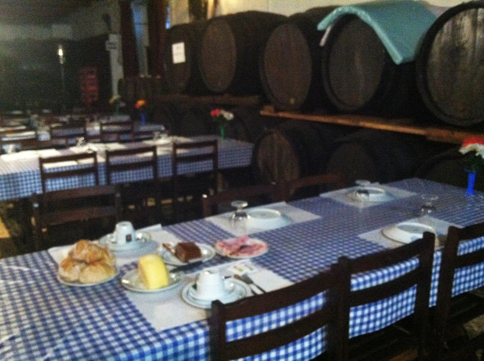
Saturday, September 10, 2016, 7:47 AM – Albergaria-a-Velha: Restaurante
Casa da Alameda – dining/breakfast room with large wine barrels on both sides;
our food on nearest table.
MT 7:54 AM – Albergaria-a-Velha: Restaurante Casa da Alameda –
dining/breakfast room with large wine barrels on side wall; our food on nearest
table.

7:49 AM – Albergaria-a-Velha: Restaurante
Casa da Alameda – food on our table.

MT 7:55 AM – Albergaria-a-Velha: Restaurante
Casa da Alameda – food on our table.
We
asked the waitress what kind of cheese we were eating, and she showed us a
whole cheese in the package, labeled “Queijo Curado Ribadouro” (cured cheese
Ribadouro)

7:52 AM – Albergaria-a-Velha: Restaurante
Casa da Alameda – whole Queijo Curado
Ribadouro.
Ribadouro (meaning river
bank of the Douro) is a village and a former freguesia (civil parish), on the Rio Douro river, upriver from the
port of Porto, in the district of Porto in northern Portugal.

7:52 AM – Albergaria-a-Velha: Restaurante
Casa da Alameda – our waitress/receptionist and MT.

8:05 AM – Albergaria-a-Velha: Restaurante
Casa da Alameda – other side of dining/breakfast room (where we ate lunch the
day before), with wine bottles and barrels on wall.
We
departed Casa da Alameda at 8:40. From there, we just continued to follow the
gray dots (alternate route) on Brierley’s map of the town to a point near the
Igreja Matriz, where we then turned north to rejoin the orange dots (primary
Camino route).
Right
away, Brierley’s notes said to go “over the N-1” highway. Indeed, there was a pasarela (footbridge) going up, but in a
different direction; however, arrows clearly showed us to go under the
N-1. So, we basically followed Brierley’s own advice at a later point in this
stage, to just pay attention to the waymarking.

8:53 AM – Albergaria-a-Velha: place where pasarela (footbridge) went up and over
the N-1 highway, but arrows (including the spray-painted yellow arrow on the
near end of the concrete wall) pointed for the Camino to go down and under the
highway.

9:21 AM – After Albergaria-a-Velha: Nossa
Senhora do Socorro statue in middle of intersection.
The statue of Nossa Senhora do Socorro (Our Lady of
Help), at an intersection 3.4 km north of Albergaria-a-Velha, is near the
Capela de Nossa Senhora do Socorro, also known as Santuário de Nossa Senhora do
Socorro, which is a national sanctuary created by the population of
Albergaria-a-Velha after a devastating outbreak of cholera there in the middle
of the 19th century.

9:22 AM – After Albergaria-a-Velha: Nossa
Senhora do Socorro statue in middle of intersection.
According
to Brierley’s notes, our route this day would begin “with a stretch along a lovely
forest road through eucalyptus and pine.”
In
the eucalyptus forest, we saw a sign for Albergaria-a-Nova,
nowhere near the town.

9:38 AM – After Nossa Senhora do Socorro:
sign for Albergaria a-Nova in eucalyptus forest.
Albergaria-a-Nova is an aldeia (village) in the freguesia (civil parish) of Branca, in
the concelho (municipality) of
Albergaria-a-Velha, in the district of Aveiro.
In
Albergaria-a-Nova, we stopped at a
private albergue (hostel) called Alberg Aria-a-Nova for Don to use the banho. MT talked with a young man named
Albert, who said they had 20-some places for pilgrims (€10) and also 2 rooms
(€40) that they rent to students. They had only been open for one year, but
should be in the next edition of Brierley’s guidebook.

Albergaria a-Nova: carimbo stamp from Alberg Aria a-Nova “Albergaria
a-Nova, 3850-501 – Portugal, Albergaria.eu, FB/hostel albergaria” with arrows
pointing 300 km to Santiago and 165 km to Fátima. Although the carimbo is dated “09/09/2016,” we did
not arrive there until September 10.

MT 10:18 AM – Outskirts of Albergaria
a-Nova: Alberg Aria a-Nova – Albert with statue of Santiago.

10:22 AM – Outskirts of Albergaria a-Nova:
signs by street for private albergue
Alberg Aria a-Nova, at right; yellow arrow on utility pole at left indicated to
keep going straight.

10:23 AM – Outskirts of Albergaria a-Nova: signs
by street for private albergue Alberg
Aria a-Nova, at right; yellow arrow on utility pole at left indicates to keep
going straight; black arrow, under symbol for albergue, points to hostel;
scallop shell indicates 300 km to Santiago.
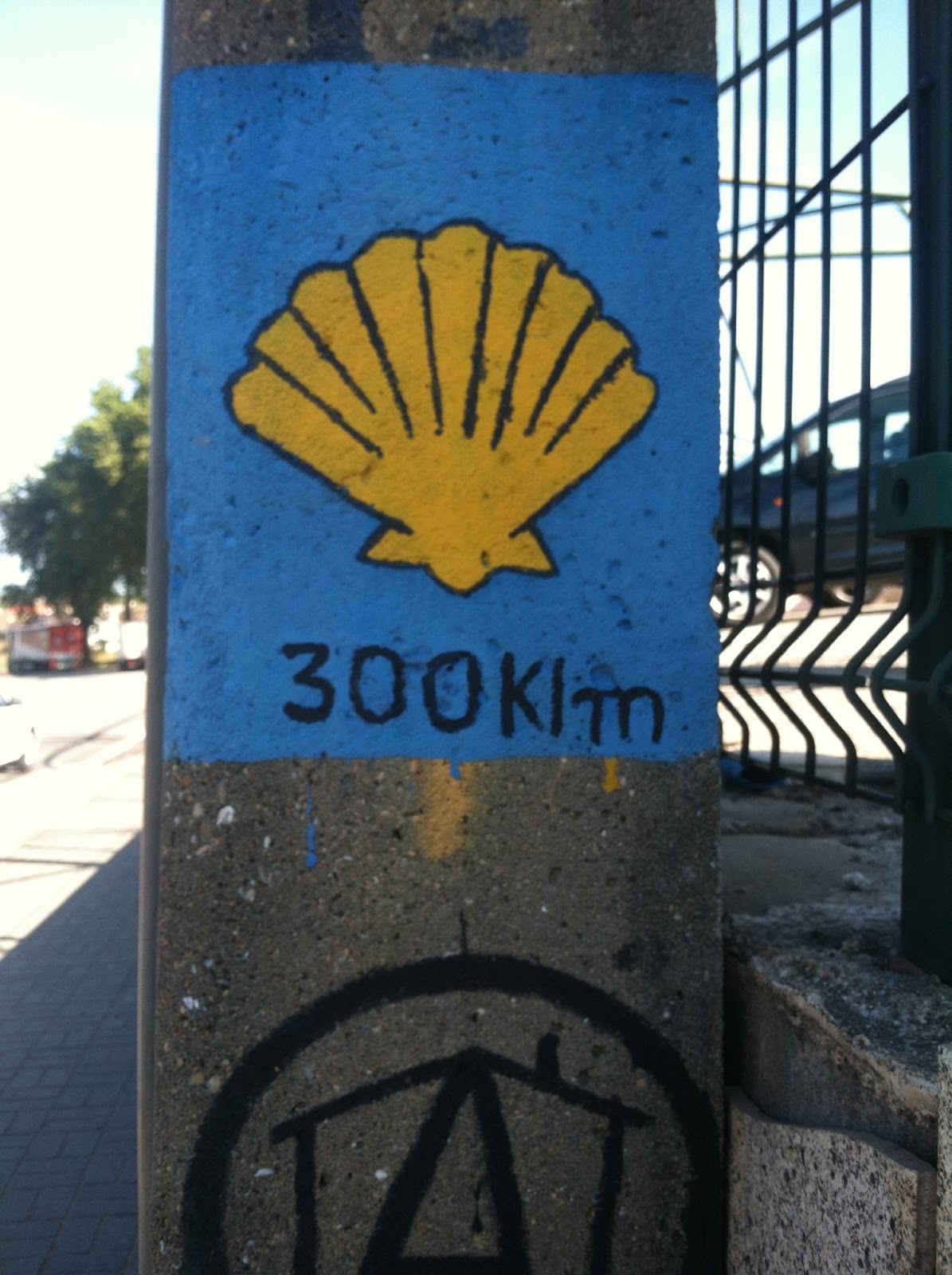
MT 10:30 AM – Outskirts of Albergaria a-Nova: sign by street for private albergue Alberg Aria a-Nova; scallop
shell indicates 300 km to Santiago.

10:27 AM – Albergaria a-Nova: sign for
entering town.
After
Albergaria a-Nova, Brierley’s notes said to turn left off the N-1 “to join
railway line.” Apparently, this meant to follow a narrow dirt path next to the
railroad tracks. Soon, we found a Camino marker next to that path, which
confirmed this to be the right way.

11:25 AM – After Albergaria a-Nova: MT on
narrow path by railroad tracks (just over MT’s shoulder is the Camino marker by
this path).

11:26 AM (Cropped) – After Albergaria
a-Nova: Camino marker on narrow path by railroad tracks; it reads: “Caminho de
Santiago – Oliveira de Azeméis,” although it was still 12.7 km to that town.

MT 11:34 AM – After Albergaria a-Nova: Don
with Camino marker on narrow path by railroad tracks; it reads: “Caminho de
Santiago – Oliveira de Azeméis,” although it was still 12.7 km to that town.

11:50 AM – Pinheiro da Bemposta: railroad
station (not working).
By
the railroad station in Pinheiro da
Bemposta, we asked a man about taking a train, and he said it was better to
take a taxi from there. When we said we had no working phone (we were using
MT’s iPhone for Internet only), he went to a nearby building to get someone to call a taxi. However, MT
then changed her mind, and decided to go on to Oliveira de Azeméis.
Pinheiro
da Bemposta
is a lugar (place, i.e., small village)
in the former freguesia (civil
parish) of Pinheiro da Bemposta, belonging to the cidade (city) and concelho
(municipality) of Oliveira da Azeméis, in the district of Aveiro. According to
tradition the name Pinheiro (meaning pine) comes from a large pine tree that
existed next to the old road. The name Bemposta (meaning well posted)
comes from its airy, elevated position
with a wide panoramic view.
Historically, this was an
important settlement. It was located in a freguesia
(civil parish) formerly known as Figueiredo, which was on a section of the
Roman military road. There are documents mentioning Figueiredo in 1114. However,
the settlement of Pinheiro da Bemposta existed in more ancient tiles, and had
already appeared in a document of 1109.
The vila (village) of Pinheiro da Bemposta and seat of the concelho (municipality) of Bemposta was
created in 1514, with a foral
(charter) granted by King Manuel I. Therefore, it has a pelourinho (pillory); it also has a crucifix Cruzeiro do Pinheiro
da Bemposta, dated 1604, which is a National Monument. The concelho had a population of 9,722 in 1801 and 8,113 in 1849, but
was extinguished in 1855. In the first decades of the 20th century, a large
part of the population emigrated to Brazil. This emigration gained momentum in
the 1950s and continued throughout the 20th century, with some also going to
Venezuela, Canada, and the United States. Still, up until the administrative
reorganization of 2013, Pinheiro da Bemposta was a semi-urban freguesia (civil parish, pop. 3,324 in
2011) in the concelho of Oliveira de Azeméis.
That parish was extinguished in 2013 and became part of the União das
Freguesias de Pinheiro da Bemposta, Travanca, e Palmaz (Union of the Civil
Parishes of Pinheiro da Bemposta, Travanca, and Palmaz).

12:00 PM – Pinheiro da Bemposta: covered
crucifix, Cruzeiro do Pinheiro da Bemposta
in square in middle of intersection, in front of fancy building.
The Cruzeiro do Pinheiro da Bemposta (Crucifix of Pinheiro da Bemposta),
on the Largo do Cruzeiro (Square of the Crucifix) in the center of the village,
was erected in 1604 in the Mannerist style and was rebuilt in the Rococo style in
1774 in its current configuration. (The figure of the crucified Christ is
certainly from 1774, replacing an earlier one.) It has been classified as a
National Monument since 1910, when it was restored. On a plinth of three steps
stands a small, quadrangular shelter formed by four pillars crowned by
pinnacles and topped by a pyramidal roof. Under this shelter is a cross resting
on a half-column with a bulb-shaped pedestal. The arms of the cross end in
fleur-de-lis. The whole structure is surrounded by a railing.

11:58 AM – Pinheiro da Bemposta: the covered
Cruzeiro do Pinheiro da Bemposta.

11:59 AM – Pinheiro da Bemposta: side view
of covered Cruzeiro do Pinheiro da Bemposta.
After
taking us up through the historical center
of Pinheiro da Bemposta, the Camino route went back down over the N-1 highway.

12:25 PM – After center of Pinheiro da
Bemposta: building with balconies and coat of arms.

12:21 PM – After center of Pinheiro da Bemposta: coat of
arms on older building (telephoto 76 mm).
Many
of the villages we passed through had no sign identifying them at the edge of
town. Our best guess was that the next one (shown on Brierley’s map) was Travanca.
Travanca (pop. 1,804) is a town and
former freguesia (civil parish) in
the União das Freguesias de Pinheiro da Bemposta, Travanca, e Palmaz (Union of
the Civil Parishes of Pinheiro da Bemposta, Travanca, and Palmaz), in the
concelho (municipality) of Oliveira de Azeméis. The name Travanca (meaning
obstacle) relates to the nature of the land and most of the functions of its
residents in the troubled times of the Middle Ages.

12:31 PM – Travanca?: street entering town
(no sign).

12:34 PM – Travanca or Besteiros?:
horse-drawn cart with couple who seemed to be selling tomatoes (telephoto 186
mm).
Then
we came to the village of Besteiros.

12:36 PM – Besteiros: sign for entering town
(not in Brierley’s notes or map), with yellow Camino arrow painted on post of
sign.
Besteiros is a village in
the freguesia (civil parish) of Travanca
(since 2013 part of the União das Freguesias de Pinheiro da Bemposta, Travanca,
e Palmaz [Union of the Civil Parishes of Pinheiro da Bemposta, Travanca, and
Palmaz]), in the concelho (municipality) of Oliveira de Azeméis. The village
takes its name from the Besteyros family, who owned properties in this area
until the 16th century.

12:40 PM – After Besteiros: some town ahead,
before woods on horizon.

12:41 PM – After Besteiros: same town, now
with much larger city (probably Oliveira de Azeméis) ahead on horizon, both to
left and right of trees in center.
Oliveira
de Azeméis
is a cidade (city, pop. 12,000) and a
concelho (municipality, pop. 68,611)
located in the Porto Metropolitan Area. A Roman miliário (milestone) is evidence of the town’s early foundations as
part of the Via Romana XVI. The municipality was created in 1799. Here one
encounters the first official Camino marker post from the Junta de Galicia in
Portugal.
Near
Oliveira de Azeméis, we saw our first Portuguese hórreos (corncribs).

1:17 PM – Outskirts of Oliveira de Azeméis: another
view of our first Portuguese hórreo.
For more information on hórreos,
see Appendix D, Variants of Hórreo in
Galicia and Beyond, in http://madillcamino2014.blogspot.com.

1:33 PM – Oliveira de Azeméis: another
Portuguese hórreo, with multiple
floors for storing corn, on Rua da Portale (we never saw the portale gate).

1:35 PM – Oliveira de Azeméis: another
Portuguese hórreo, with multiple
floors for storing corn, on Rua da Portale (we never saw the gate) (telephoto
54 mm).
We
arrived at the Largo da República in Oliveira de Azeméis around 2 pm. We had
already walked 19.8 km, and it was still another 9.4 km to São João da Madeira,
where we had reservations for the night. So, we turned east on Rua Dr. António
José de Almeida, but then turned south to look for a taxi rank (according to Brierley’s map, there was supposed to be
one near Pensão Anacleto). Seeing neither pensão
(pension, boarding house) nor taxis, we asked a man on the street, who told us
to go back up Rua Almeida to the north, and the taxis would be by a park. When
we got to the park, we could see no taxis and asked a couple of old men on a
park bench, who pointed us to another white-haired man on another bench. That
man was apparently in charge of the taxis, but he said all the taxis were gone.
(Then Don saw all the empty parking spaces marked “Taxi” on the east side of
the park.) The man told us that a taxi to São João de Madeira would cost about €10,
but said it was better to take a bus, from the bus stop on the west side of the
park. While we waited at the bus stop, he came over to us holding a key in his
hand and said that he, personally, could take us to São João da Madeira. He
brought the car (not a taxi) around from the east side, and we headed out.
On
the way to São João da Madeira, we told him we wanted to go to Hotel AS on
Praça Luis Ribero, and he seemed to say he knew where it was (we offered him
the map on our lodging voucher). When we got into the town center, he stopped
and asked a young man on the street how to get there. The young man tried to
explain, but then just got into the car to show us the way. When we got to a
street about a block west of Praça Luis Ribeiro, he had the driver stop. and
the three of us got out of the car. (The problem turned out to be that the praça (plaza, square) was in a
pedestrianized zone, where cars could not go.) We assumed the driver would want
€10, but when we tried to pay, he wanted nothing. The young man took us to the praça, on which Don had seen a tall
column from where the car stopped; he told us the hotel was next to the bank.
MT offered to pay the young man something for his trouble, but he too refused.
The whole trip had lasted from 2:20 to 2:40 pm.
São
João da Madeira
(St. John of the Wood), commonly abbreviated as SJM, is a cidade (city, pop. 21,713) and concelho
(municipality) in the District of Aveiro and the Metropolitan Area of Porto.
SJM is the smallest Portuguese municipality in area with a single freguesia (civil parish) corresponding
to the area of the city. Its strong development in the second half of the 20th
century led to the expansion of its urban area beyond the confines of its small
municipality. It became an autonomous municipality of the nearby Oliveira de Azeméis
in 1926 and was elevated to the status of city in 1984. The city is known for
its tradition in the industrial area, particularly in the manufacture of hats
and footwear.
The origins of SJM go back a long
way, as evidenced by the legacies of Celtic, Roman, Arab, and Visigothic
civilizations. However, the first written mention of the name was in documents
of 1088, still before the emergence of Portugal as a country, which referred in
Latin to “Sancto Ioanne que dicent Mateira.” The patron saint of the
village/city/municipality is São João Baptista (St. John the Baptist). The Madeira
part of the place name seems to have to do with the abundance of woods in the
region. For many centuries, the small village of SJM went unnoticed in the
national context. In the middle of the 19th century, however, it became the
major focus of the Industrial Revolution in Portugal. The production of hats
was the first industrial activity there. In the 20th century, the headgear
activity would decline while the footwear industry grew, eventually becoming
the main economic activity in the city.

Sunday, September 11, 2016, 9:30 AM – São João da Madeira: Hotel AS,
entrance on right corner, and bank to left (we first arrived at hotel by
walking up street at right, with parked cars, which led to the pedestrianized
Praça Luis Ribero).
When
we got to Hotel AS and asked if we could still get lunch instead of dinner,
the receptionist called the nearby restaurant Ponto Zero (the hotel had no restaurant) and they said OK, if we
came right away, since lunch stopped at 3 pm. We got a 0.5-liter bottle of red
wine (“Dona Carla, Douro DOC, Tinto/Red”); 0.5-liter bottle of water;
appetizer: tuna salad and small breads; first course: crema de legumes (cream of vegetable) soup; main course: both had robalo escaldado (snook [fish],
literally burnt or scalded = grilled) with cooked potatoes and large salad;
desert: MT strawberries, Don apples (sliced with cinnamon). Although this mean
was covered by our voucher, suggestions on the board outside the restaurant
said Menu 7€ and Plato (plate, a la carte) €5.


São João da Madeira: extra large carimbo stamp from “Hotel A.S., S. João
da Madeira, info@hotel-as-sjmadeira.com | Tlf. 00351-256 836 100” dated both “10/09/16”
and “11/09/16” since we would be staying there a second night.
Back at Hotel AS, we first had to finish registering (since we had had to hurry to the restaurant). Then we found the emergency phone number for the Follow the Camino company, through which we had booked our reservations. Their itinerary for the next day called for us to walk to Grijo (19 km) and go to the monastery, to be picked up at 3 pm and transported back to São João da Madeira for a second night at the same hotel (the reason being that there was no suitable lodging in Grijo, only a pilgrim hostel); then we were to be picked up at the hotel at 8:30 am Monday and transported back to Grijo to start the next day’s walk. Based on this day’s experience, we had serious doubts about being able to make it to Grijo by the appointed pick-up time. So, we called to cancel the 3 pm pick-up but keep the 8:30 am pick-up for Monday morning. (That would give us an extra day in São João da Madeira to rest up for the walk from Grijo to Porto.) They asked if we wanted the transport on Monday to take us to Grijo or all the way to Porto. After some thought, MT said Grijo.
Then
we went to our room, showered, washed clothes, and hung them on our balcony.
After
a while, we went out to find a place to buy some fruit for an evening snack. On
the Praça Luis Ribero, right in
front of our hotel, we saw a large group doing zumba step dancing.

Saturday, September 10, 2016, 6:41 PM – São João da Madeira: Praça Luis
Ribero – zumba step dancing right outside our hotel.

MT 6:49 PM – São João da Madeira: Praça Luis
Ribero – zumba step dancing right outside our hotel.

6:41 PM – São João da Madeira: Praça Luis
Ribero – zumba step dancing right outside our hotel, with Pirilau tower in
background.
The famous chimney-shaped tower,
officially called Monumento á Indústria (Monument to Industry) but nicknamed “Pirilau” by the people, was erected in
the Praça Luis Ribero in 1992, as a “lofty marble chimney” to highlight the industrial
spirit of the people of São João da Madeira.
In January, 2017, the City
Council decided that the tower will be destroyed during the revitalization of
the center of the city, in which cars would again be allowed to circulate in
the square.

6:42 PM – São João da Madeira: Praça Luis
Ribero – zumba dancers with bank (at left) and Hotel AS entrance at far right
end of building.
After
we passed a clothing shop with, live models in the window, Don had to rush back
to the hotel to use the banho
(bathroom). Meanwhile, MT went on, first to a mercado (grocery store), which was closed, then to a frutaria (fruit store), where she
bought apples, grapes, pears, peruanos
(?), and plums for a total of €4+.

6:48 PM – São João da Madeira: people on
sidewalk and live models in window of “Be Yourself” shop.
Then
we went back to Restaurante Ponto Zero
for sangrias. Rather than two glasses for €3 each, the girl (Tania) convinced
us to buy a whole 1-liter jarro
(pitcher) for €8.

7:21 PM – São João da Madeira: Restaurante
Ponto Zero - exterior.

MT 7:39 PM – São João da Madeira:
Restaurante Ponto Zero – Tania with our pitcher of sangria.
No comments:
Post a Comment