This post is based primarily on
Don's notes, occasionally supplemented with MT's notes from our Camino in 2016.
When information from other sources is added—for further explanation to readers
or to satisfy our own curiosity—that is set off in a text box (as this one).
Most of the photos that accompany
this post are from Don’s camera (with a caption indicating the time it was
taken); those from MT’s iPhone are indicated by “MT” placed at the beginning of
the photo caption. Photos from any other source (such as the public domain
Wikimedia Commons) indicate that source in the caption.
We
went to buffet breakfast at Axis Vermar
Hotel around 7:15.
We
departed the hotel at 8:35. We were able to just go out the back entrance, past
the pools to a gate that led to the street on the Camino route.
The
Coastal Route from this point was much different from the first day. There were
few other pilgrims (most seemed to have followed Brierley’s guidebook, which
said to turn inland at Vila do Conde to go back to the Central Route). We were
no longer hugging beaches, the Camino signage was less frequent and less clear,
and we now had only the Follow the Camino walking notes for directions.
The
Follow the Camino walking notes were not very useful. The English seemed to be
a poor translation, not done by a human being. (Twice during this day, it would
tell us to do something at a “T’ junction and once at an “X” junction (which we
thought we could understand), but then it twice told us to turn at “the white
junction” (which we never figured out). It would tell us to do something at a
point so many km from the day’s start (as if we would know that distance), but
only rarely said what town you were in or near. We just had to follow the
yellow arrows and, when in doubt, generally follow the coastline.
We
went through several towns and villages the notes never mentioned, and even in
those places the arrows were sometimes “sneaky,” for example, on the side of a
curb you might not be able to see from the sidewalk. Sometimes we had to go
back to an intersection and look more carefully or had to ask local people.

Thursday, September 15, 2016, 8:37 AM - Póvoa de Varzim: MT on boardwalk
wet from overnight rain.

8:42 AM – After Póvoa de Varzim: MT on
boardwalk, approaching piles of seaweed on beach; small blue sign with yellow
Camino arrow and scallop shell on concrete at right.
Early
on, we had some boardwalks, but we eventually came to a place where more
boardwalks were under construction. That was where we had to go across grass
(on a worn path) to a street where yellow arrows continued.
At “Km 5.1” after leaving Póvoa
de Varzim, the Follow the Camino walking notes said: “The cobblestone track
comes to an end, I recommend you to take right across the grass field . . . .”

8:43 AM – After Póvoa de Varzim: people
harvesting seaweed by raking it into piles on beach.
After 6 km, the walking notes
said: “You’re reaching a dirt track road drifting left and right, continue on
this one by the white cross.” (It didn’t say what to do at the white cross.)
The next sentence said: “After 100m continue left by a wind mill.” (We would
finally come to a windmill 34 minutes later.)

9:09 AM – After Póvoa de Varzim: lady with
horse-drawn cart, turning right on paved road at intersection near a white
cross.

9:09 AM – After Póvoa de Varzim:
intersection near a white cross, where a paved road went to the right and the
paved road we were on curved around to the left, passing the white cross.

9:09 AM (Cropped) – After Póvoa de Varzim: Fortunately,
there was another small blue sign (see red circle) on the stone wall at the
corner with a yellow Camino arrow and scallop shell pointing to the road that
went straight and to the left.

9:14 AM – After Póvoa de Varzim: more
boardwalk.
After
this stretch of boardwalk, we never saw
the sea again until just in front of our hotel at the end of the day’s walk.

9:43 AM – After Póvoa de Varzim: old
windmill.

10:01 AM – After Póvoa de Varzim: colorful
old camper with logo for “Aminon clothing” (telephoto 156 mm).

MT 10:09 AM – After Póvoa de Varzim:
colorful old camper with logo for “Aminon clothing” on the side.

10:02 AM – After Póvoa de Varzim: colorful
old camper with logo for “Aminon clothing” on the side and also an electric cord forming “Aminon” on the front (telephoto 54 mm).

10:03 AM – After Póvoa de Varzim: other
side of colorful old camper with logo for “Aminon clothing” on the side and also
an electric cord forming “Aminon” on the front.

10:14 AM – Vila de Aguçadoura: sign
entering town, with small blue sign on base with yellow Camino arrow pointing
to right.

MT 10:14 AM – Vila de Aguçadoura: Don with sign
entering town, with small blue sign on base with yellow Camino arrow pointing
to right.
Aguçadoura is a vila (village) in a former freguesia (civil parish, pop. 4,257) of
the same name but since 2013 in the União das Freguesias de Aguçadoura e Navais
(Union of the Civil Parishes of Aguçadoura and Navais, pop. 5,736) in the
municipality of Póvoa de Varzim. The village is located near the coast, 6 km
north of Póvoa de Varzim. The name of the village, sometimes translated as
Scaffolding, derives from petra
aguzadoira (sharp stone or stone for sharpening agricultural tools), the
name by which the place was called in its earliest documentation in 1258.

10:22 AM – After Vila de Aguçadoura:
vegetable fields (we saw people picking) and greenhouses.

10:28 AM – After Vila de Aguçadoura: signs
pointing off to right to Estela and Navais; small blue sign on stone wall with
yellow Camino arrow pointing to left.
Early
in the day, it started to sprinkle, and we had to break out our rain gear at an
unidentified village, where two
ladies and a man motioned to us to come out of the rain into a building where
they were cleaning harvested onions.

10:37 AM – After Vila de Aguçadoura: lady
cleaning onions; and MT in rain gear.

MT 10:44 (or 10:37 by Don's camera) AM – After Vila de Aguçadoura:
lady cleaning onions.

10:38 AM – After Vila de Aguçadoura: another
lady cleaning onions; first lady now standing at right.

10:40 AM – After Vila de Aguçadoura: more
lettuce fields and greenhouses.

10:51 AM – After Vila de Aguçadoura: pile
of rocks with yellow arrow (and a faint white arrow) pointing off cobblestone
path to right.

10:52 AM – After Vila de Aguçadoura:
another old windmill (telephoto 360 mm).

11:02 AM – After Vila de Aguçadoura: MT on
muddy dirt path, where cobblestones ended.

11:18 AM – After Vila de Aguçadoura: more cobblestones
through forest.

MT 11:25 AM – After Vila de Aguçadoura: Don
on path with more cobblestones through forest.

MT 11:26 AM – After Vila de Aguçadoura: Don on path with more cobblestones
through forest.

MT 11:26 AM – After Vila de Aguçadoura: MT
on path with more cobblestones through forest.
The
next identifiable village was Apúlia,
in the municipality of Esposende. We were now in the District of Braga, rather
than of Porto.
Apúlia is a village
(pop. 4,198) in the União das Freguesias de Apúlia e Fão (Union of the Civil
Parishes of Apúlia and Fão, pop. 7,301) in the municipality of Esposende. Over
the centuries, the name has appeared in various documents as Apulha, Pulha,
Puglia, Pulla, or Pulia. Apúlia goes back to the Visigoth era, indicating that
the name may have been influenced by the Italian province of Puglia. The name
Apúlia seems to have evolved from the name Pulia (in ancient Roman Latin) and
Pulha (in Portuguese) for the Italian region.
Apúlia’s most iconic features are
a number of old windmills (existing from at least the 18th century) set in the
dunes at the northern end of the Praia de Apúlia beach. These no longer have
their sails and have been converted into accommodations.
In
Apúlia, we came to a church that we thought was locked until we saw a man
coming out of the door. Inside, we found a self-service carimbo stamp from “Paroquia de Apúlia (S. Miguel)” (Parish of Apúlia
[St. Michael]) for our credenciales. This
stamp caused us to think the church was called Igreja de São Miguel (Church of
St. Michael); however, it turned out to be the Igreja Matriz.

11:28 AM – Apúlia: side of Igreja Matriz,
where we got self-service carimbos; bell towers topped with cross and scales.

Apúlia: carimbo stamp from “Paróquia de Apúlia (S. Miguel) – Arciprestado de
Esposende – Arquidiocese de Braga” [Parish of Apúlia (St. Michael) - Archpriestship of Esposende -Archdiocese of Braga]; inside, around the image of the church and a scallop shell, is
“Caminho Portugués da Costa [Portuguese Camino of the Coast] – Esposende.”
The
Igreja Paróchial de Apúlia (Parish
Church of Apúlia) is dedicated to São Miguel (St. Michael) and is sometimes
called Igreja Paróchial de São Miguel
(Parish Church of St. Michael). The web sites of the village www.viladapulia.blogspot.com and the freguesia (civil parish) www.apuliafao.freguesias.pt both call
this Igreja Matriz de Apúlia (Mother
Church of Apúlia). The religious parish is the Paróquia de São Miguel de Apúlia
(Parish of St. Michael of Apúlia) or, on the web site of the Archdiocese of
Braga, Paróquia de Apúlia (S.
Miguel).
Despite
the external appearance of the church, its construction is very recent; it was
built in 1945. It is of Neoclassical style and has tall bell towers on both
sides of the main body, where the image of the patron saint is placed inside a
niche. In the interior, it has three naves and conserves a beautiful custódia (tabernacle?) of Renaissance style; everything
else is new.
It is one of the most emblematic
structures of Apúlia. According to tradition, the first church in this parish, in
Romanesque style which existed by the 12th or 13th century, located in Agra dos
Mouros, was already in ruin by the 17th century and now submerged under the
sands. The Apulians decided to build another church in 1694. Part of this
church was an imposing custódia (tabernacle?)
of gilded silver, inlaid with fine stones, in Renaissance style. At the time of
the French invasions (1809), it was hidden inside a tank. By the middle of the
19th century, churches in the municipality of Esposende suffered a great number
of assaults, to steal objects of greater value, and this church was again
ruined in 1845. In 1936, when the church was again in a degraded state and was
becoming too small, the people decided to build a new one, which was dedicated
in 1945.
An arciprestado (in Portuguese, arciprestazgo in Spanish, archpriestship or archpriesthood in English), also called descanto
(deanery) or vicariato (vicariate),
is a grouping of parishes, neighboring each other, within a diocese. The bishop
may establish one to facilitate pastoral care of the faithful in particular
(usually rural) district of a diocese. The arcipreste
(archpriest), also called decano
(dean) or vicario (vicar), is the
title of the priest who is in charge of administering such a district and is
the head of all the clergy in it. Formerly, as early as the 4th century, the
archpriest was the oldest ordained priest of a church in the diocese or the one
whom the bishop designated as the most eminent. His function was to replace the
bishop, for example in case of illness, in the ceremonies of worship. Today,
the term archpriest is most often
used in Eastern Orthodoxy and the Eastern Catholic Churches, but may be
somewhat analogous to a monsignor in the Roman Catholic Church.
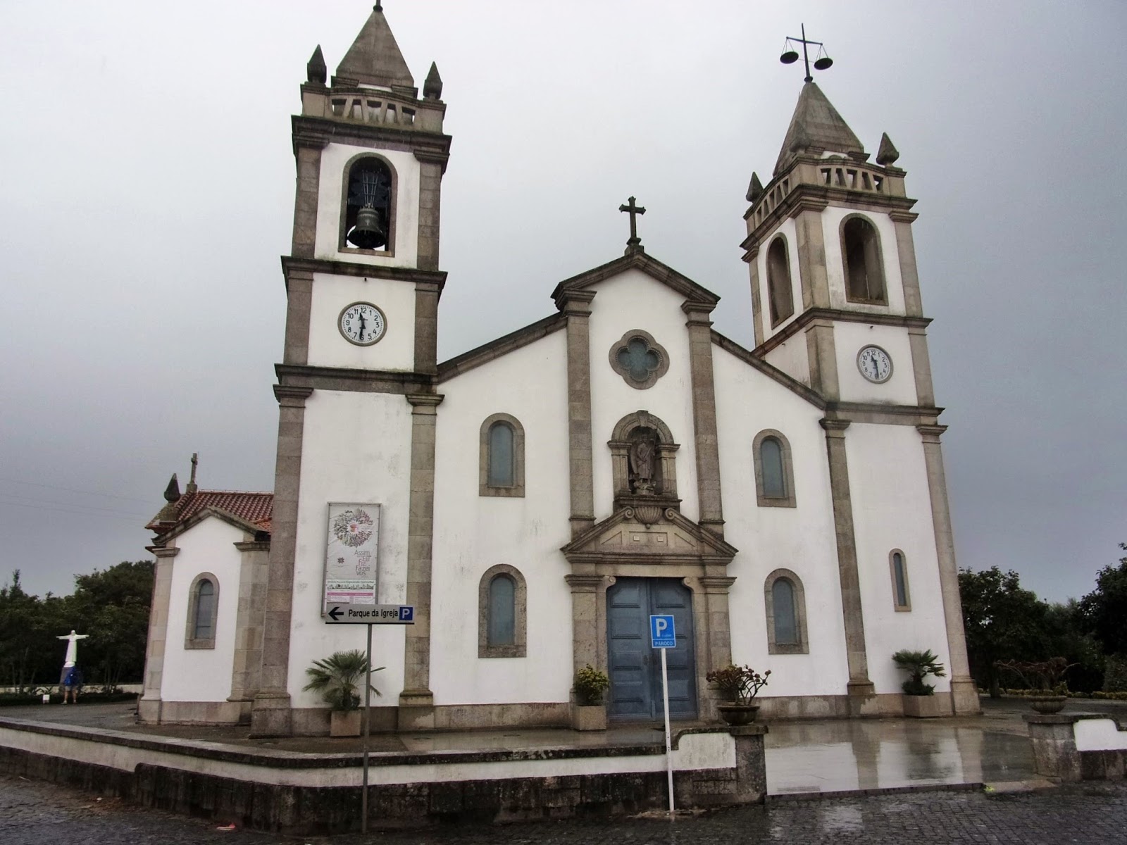
11:28 AM – Apúlia: façade and bell towers
of Igreja Matriz; pavement still wet from rain.

11:29 AM – Apúlia: Igreja Matriz - sign made
of azulejo tiles next to church for
sister parishes in Apúlia and S. Tíago in Cabo Verde Africa; beneath it: Parochial
Center Village of Apúlia.

11:30 AM – Apúlia: Igreja Matriz – view
from rear of central nave to main altar in apse; the church was very wide, with
3 naves.

11:33 AM – Apúlia: Igreja Matriz – main
altar in apse.

11:33 AM – Apúlia: Igreja Matriz – view
from apse toward rear of central nave, with circular window at top center of
rear wall, above organ in loft.

11:34 AM – Apúlia: Igreja Matriz – circular
stained glass window at top center of rear wall, with dove symbolizing Holy
Spirit (telephoto 360 mm).

MT 11:43 AM (Cropped) – Apúlia: Igreja
Matriz – another stained glass window on rear wall.

11:35 AM – Apúlia: Igreja Matriz –
baptismal font at front of right nave, with statue of John the Baptist above
it, flanked by murals of the Baptism of Christ (left) and Pentecost (right).

11:36 AM – Apúlia: Igreja Matriz –
baptismal font at front of right nave, with statue of John the Baptist above
it.

11:36 AM – Apúlia: Igreja Matriz – statue
of John the Baptist above baptismal font at front of right nave (telephoto 90
mm).

MT 11:40 AM – Apúlia: Igreja Matriz – mural
of the Baptism of Christ to left of baptismal font at front of right nave.

MT 11:40 AM – Apúlia: Igreja Matriz – mural
of Virgin Mary and 11 disciples at Pentecost to right of baptismal font at
front of right nave.
After
Apúlia, we continued on more muddy dirt paths.

12:06 PM – After Apúlia: MT on another muddy
path with large puddles.
Soon
we came to Fão.
Fão is a village
(pop. 3,080) in the União das Freguesias de Apúlia e Fão (Union of the Civil
Parishes of Apúlia and Fão) in the municipality of Esposende. (The name Fão can
be translated as fan, or beauty therapy.) The village is known for its beach,
the Praia de Ofir. The village of Barreiras in this freguesia has the largest medieval necropolis (cemetery) of the
Iberian Peninsula and one of the most important (Necrópole Medieval de
Barreiras), which dates back to the time of the Black Death in the 9th century
and was discovered in 1924. During the medieval era, Fão was an important
center of salt production. The historical nucleus of the village dates from the
16th and 17th centuries.
In
Fão, a lady celebrating her 50th anniversary that weekend saw us leaving the
locked church and took us to the sacristan’s house, where a lady got the carimbo stamp from “Irmandade do Senhor
Bom Jesus de Fão” (Brotherhood of the Lord Good Jesus of Fão) for us.


Fão: carimbo stamp from “Irmandade do Senhor Bom Jesus de Fão”
(Brotherhood of the Lord Good Jesus of Fão).

12:49 PM – Fão: MT being greeted by kind
lady in front of Igreja do Bom Jesus church with sacristan’s house in right
background.
The Igreja
do Bom Jesus (Church of the Good
Jesus), also known as Templo do Bom Jesus (Temple of the Good Jesus), in Fão is
on a site where a small chapel had existed since the 17th century. The current
church dates from the early 18th century, built between 1710 and 1724. It has a
main façade facing north and the tower with gargoyles and topped with pinnacles
attached to the south end. The Renaissance main door is topped by a “broken” pediment
(with a gap at the top), above which is a well-proportioned ellipsoidal rosary
framed by floral motifs. The façade is topped with a triangular pediment in
which a royal coat of arms is painted in beige, light blue, and white. That
pediment has pinnacles at its two side corners and a cross at its top point. In
front of the church is an atrium enclosed on three sides by low, thick stone
walls with pillars topped by massive stone balls.
The current church is a typical example
of a pilgrimage church. According to oral tradition, the romaria (pilgrimage procession) of Senhor Bom Jesus in Fão dates
from the 16th century, when a woman gathering firewood found an image of the Senhor
Bom Jesus (Lord Good Jesus, a traditional image of Jesus, scourged and crowned
with thorns during his Passion, similar to Ecce Homo) in a mire on the left
bank of the Rio Cávado. In 1707, the Bishop of Braga found the old chapel to be
in a state of ruin and made arrangements to build a new church; construction
began in 1711. In 1721-22, the holy image of Bom Jesus was placed in the main
altar.
The procession still takes place annually
on Monday of Holy Week. Festivities following the procession are in the
churchyard. The procession and festivities are organized by the Irmandade do Senhor Bom Jesus de Fão
(Brotherhood of the Lord Good Jesus of Fão), which was founded in 1711. In 1863,
King Dom Luis I granted an Alvará Régio (Royal Permit) to the Brotherhood to be
patrons and protectors of the church, which was elevated to the status of Royal
Chapel in 1871, and the royal coat of arms was placed on the church in 1873.

12:50 PM – Fão: kind lady in front of Igreja
do Bom Jesus church with sacristan’s house in right background.

1:01 PM – After Fão: view from south bank
of Ponte Luís Filipe bridge over Rio Cávado toward Esposende.
The Ponte Luís Filipe bridge, popularly known as Metálica de Fão (Metalica
of Fão) or Ponte de Fão (Bridge of Fão), is a unique example of the period of
Arquitectura do Ferro (Architecture of Iron) in the municipality of Esposende.
By the middle of the 19th
century, there was public clamor for construction of a bridge linking the north
and south parts of the municipality. Around 1870, the celebrated French
engineer Gustave Eiffel was living in the nearly city of Barcelos. Abel Maria
Mota was one of Eiffel’s disciples, and his first project was to design the
bridge over the Rio Cávado. It was therefore common to hear that this bridge
was a work of Eiffel. Construction began in 1889, and it was inaugurated in
1892, named in honor of Luís Felipe, who was then crown prince. The bridge
measures 267 m, divided into 8 spans, each 38.5 m long. It rests on 7 masonry
pillars. It was classified as an Imóvel de Interesse Público (Property of
Public Interest) in 1986.

1:01 PM – After Fão: on the way to bridge,
sea gull and boats on Rio Cávado, with Esposende on far shore.

1:01 PM – After Fão: north end of bridge
over Rio Cávado, with Esposende on far shore.
After
crossing the bridge over Rio Cávado (not mentioned in text of the walking notes,
but shown on a map) and walking 1-2 km, we entered Esposende.
Esposende is a city (pop.
9,197) in a municipality (pop. 34,254) of the same name in the District of
Braga. It is situated on the final stretch of the Rio Cávado before it empties
into the Atlantic Ocean. The town was a fishing port that actively participated
in the Portuguese Age of Discoveries in the 15th and 6th centuries. During the
reign of King Manuel I (1495-1521), its population made great efforts to obtain
a foral (royal charter), but only received
it during the reign of Sebastião I (1557-1578) in 1572.
The Praia de Ofir, also claimed
by Fão, is on long spit of land forms the seaward bank of the Cávado. That 3-km
stretch of sand backed by dunes is part of the Litoral de Esposende Protected
Landscape.

1:27 PM – Esposende: Stone marker for
Avenida Engenheiro Eduardo de Arantes e Oliveira.
At
an intersection where the yellow arrows said to turn right, we noticed a big
sign for Avenida Engenheiro Eduardo
Arantes de Oliveira, on which our hotel would be located. So we just went
straight there, to the second roundabout (a long way).

1:27 PM – Esposende: Stone marker for
Caminho Portugués da Costa – Esposende, in same small park and actually more on
our street than where arrows pointed.

MT 1:34 PM – Esposende: Don with stone
marker for Caminho Portugués da Costa – Esposende.

1:50 PM – Esposende: approaching Hotel
Suave Mar, in next block.

Esposende: carimbo stamp for “Hotel Suave Mar, Martins e Martins, Lda.,
Esposende, Avenida Eng.°
[Engenheiro = Engineer] Arantes de Oliveira – 4740-204 Esposende. Tel. (351)
253 969 400 – Fax (351) 253 969 401, Contribuinte N.° [taxpayer number] 500 640 840.”
We arrived at Hotel Suave Mar just before 2 pm and asked to have our half-board meal for lunch rather than dinner. Since lunch ended at 3 pm, we just washed our hands and went to the hotel’s restaurant. The half-board menu included: starters: olives, potato croquettes, tuna paté with various breads; first course: MT garlic soup/Don mixed salad; second course: we both had dourada grelhada (grilled sea bream or gilthead bream, 2 large fillets each) with “grilled” (cooked) potatoes and green bean-carrot mix; desert: both had fruit salad (after Don relented on getting a local specialty pastry called clarinha). We had to pay extra for a 750-ml bottle of Teoria To red Douro wine (€12.00) and ½-liter bottle of water (€1.75).
After
lunch, we showered and washed clothes and hung them of our small balcony.
Then
we went out to look for a minimercado
to buy fruit for the evening and one clarinha
to share.

5:16 PM – Esposende: stone sign for Lions
Clube de Esposende across street from Hotel Suave Mar, where the Lions Club
would meet.
On
the way, we took a side trip on the boardwalk
to see where the river met the sea (just in front of our hotel).

5:16 PM – Esposende: view from boardwalk of
ocean between dunes and beyond rock barrier with crane in distance.

5:17 PM – Esposende: view from boardwalk of
ocean between dunes beyond rock barrier (mild telephoto 46 mm).

5:20 PM – Esposende: view from boardwalk of
rock barrier separating river and sea from tidal pool.
Behind
the dunes are the Forte de São João
Baptista and the town’s lighthouse, the Farol de Esposende.

5:18 PM – Esposende: fortress and
lighthouse from near tidal pool; around the edge of the pool is the branch of
the boardwalk we took toward the fortress (telephoto 133 mm).
The Forte de São João Baptista (Fort of St. John the Baptist), also known
as Castelo de São João Baptista or Forte de Esposende, was built between 1699
and 1704. Its original function was to guard the mouth of the Rio Cávado. It
was originally star-shaped, and had at each of its corners a bastion with a
hexagonal guardhouse, but the structure has suffered some decrease in size,
making room for the lighthouse. It now has a rectangular shape with only 2 of
the original 5 corners, each with a bastion and a guardhouse.
A bastion is a structure
projecting out from the wall of a fortification, most commonly angular in shape
and positioned at the corners. It was a common element in fortifications from
the mid-16th to mid-19th centuries, designed to give wider firing range in the
age of gunpowder artillery. With bastions sticking out from the core of the
fortress, cannon mounted on them could lay down overlapping fields of fire
covering neighboring bastions and the walls between them. If a cannon or two
were put out of action, defenders could still cover the field before them. In
front of the bastion would commonly be a sloping glacis, which absorbed the impact of an attacker’s cannon shots on
the base of the bastion while also making the wall harder to scale.

5:23 PM – Esposende: fortress from platform
near ocean, with sun (mild telephoto 46 mm).

5:25 PM – Esposende: lighthouse and
fortress, with sun, and boardwalk that led to platform near ocean from which
this photo was taken (mild telephoto 39 mm).
The Farol de Esposende (Lighthouse of Esposende) is a cylindrical tower
of iron, 15 m tall and painted red, built over a round concrete base. It is one
of the few lighthouses with a metal tower in the country. It was inaugurated in
1866. Next to it is a 2-story building, painted yellow, for the lighthouse
keeper.

5:25 PM – Esposende: view from platform
near ocean, across tidal pool, back toward Hotel Suave Mar.

5:26 PM – Esposende: Hotel Suave Mar viewed
from platform near ocean, across tidal pool (telephoto 220 mm).

5:26 PM – Esposende: view, from platform
near ocean, of rock barrier, river, and long, thin dune between river and sea.
At
a small “supermercado,” we got one clarinha
(€0.80), 2 bananas (€0.39), 2 Gala apples (€0.31), and one peach (€0.33), all for
a total of €1.83 with tax.

5:44 PM – Esposende: supermercado – liquor shelves with Port wines from Ferreira (Tawny
or Branco [White] for €5.69) and other cellars in Vila de Gaia (Porto).

5:50 PM – Esposende: supermercado – liquor shelves with Port
wines (V[inho] Porto) from Ferreira cellars (Tawny or Branco [White] for
€5.69), for which price tags are switched, and Offley cellars (White Port or
Tawny for €5.15), both in Vila de Gaia (Porto).

5:45 PM – Esposende: supermercado – liquor shelves with very inexpensive wines (one for
as little as €1.05), including sparkling Lambrusco.

MT 5:48 PM – Esposende: supermercado – liquor shelves with very
inexpensive Portuguese wines, these with “royal” names: Terras del Rei (The Lands
of the King) and Real Lavrador (Royal Farmhand), each in red (tinto) and white (branco) varieties, priced €1.69-1.89.

7:00 PM – Esposende: back at Hotel Suave
Mar after supermercado – Don’s half
of clarinha.
We
read the Follow the Camino notes for the next day and got lots of laughs at the
really bad translation. Just a few examples:
Km
1.8 “After you have past the red lighthouse on the left, continue straight
through on the black second track going for to the beach.”
Km
4.2 “Take left towards the little chapel with a basketball and football beach
on your eyes, and stand on the cobblestones.”
Km
8.2 “After the bar at the white junction, …”
Km
15.2 “We are coming onto the forest we have to use our hands to pull the bike
that’s a bit dangerous a few times, it’s are a couple stones road ….”
Then
we decided not to try to use the notes anymore but just follow the arrows.
No comments:
Post a Comment