This post is based primarily on
Don's notes, occasionally supplemented with MT's notes from our Camino in 2016.
When information from other sources is added—for further explanation to readers
or to satisfy our own curiosity—that is set off in a text box (as this one).
Most of the photos that accompany
this post are from Don’s camera (with a caption indicating the time it was
taken); those from MT’s iPhone are indicated by “MT” placed at the beginning of
the photo caption. Photos from any other source (such as the public domain
Wikimedia Commons) indicate that source in the caption.
The
morning was cloudy, with a sprinkle as the transport van took us to Porto.
The transport that we had arranged to take us all the way to Porto was scheduled for 8:30, but arrived at 8:50. While waiting for the transport van in the hotel lobby, we read (as much as we could of) a Portuguese newspaper. The most memorable parts were the comics and some very graphic photos in a section of the classified ads that seemed to be offering the services of ladies of the evening. (We took a photo of the former, but not the latter.)

Monday, September 12, 2016, 8:20 AM - São João da Madeira: Hotel AS – Garfield
in Portuguese: in the 1st frame, Jon says: “It’s 11:59 pm.” In the 2nd, he
says: “Within one minute, it will be Tuesday.” In the 3rd, he says: “If my
watch stops, am I trapped in Monday?” and Garfield says/thinks: “Don’t think
about these things.”
The
driver took the N-1 and A-1 highways into Porto, not going through Grijo.
Along the N-1, we passed through
the village of Malaposta, the name
of which seemed to be the opposite of Bemposta, through which we had passed on
our way to São João da Madeira two days before, in which case it would mean
badly positioned. However, mala-posta
in Portuguese means a mailbag (mala =
suitcase or trunk, posta = mail) or a
stagecoach that transported passengers and mailbags.
As
we entered Porto, the driver
suggested dropping us off in the city
center before taking our backpacks and walking poles to Hotel Vila Galé.
Porto (pop. around ½
million in the city, with 2.1 million in the greater urban area), also known (in
English) as Oporto, is situated on the estuary of the Rio Douro (River of Gold),
with the western part of the urban area extending to the Atlantic coast. In
Portuguese, the name of the city is spelled with a definite article (o Porto; in English, the port).
Consequently, its English name evolved from a misinterpretation of the oral
pronunciation and referred to it as Oporto.
The city grew out of a modest
Celtic settlement atop what is now called the Colina da Sé (Hillock of the
Cathedral). The first known inhabitants were Proto-Celtic and Celtic people
around 300 BC. There was a Celtic castro
(hill fortress, also known as calle) at
the mouth of the Douro River. Around that fortress, on the south side of the
river, developed the primitive town of Calle or Cale. The name of the town derived
from the Castro people, also known as the Calleici
or Galleici, a Celtic people who
occupied the northwest of the Iberian Peninsula. When the Romans occupied the
Peninsula, they called this region Gallaecia
(or, less commonly, Calaecia). (In
Classical Latin there was not always a clear distinction between the letters
“g” and “c.”) The Calleici or Galleici are also the origin of today’s Galicia province in Spain and the –gal in Portugal. Around 136 BC, the
Romans established a port on the north side of the river, which they called Portus Cale, meaning the port (Latin portus) of Cale. In Roman times, the
bulk of the population probably lived on the south side of the river, but a
smaller settlement developed around the port on the north bank of the river (in
what is now the Ribeira district of Porto). The name of this town in Roman and
early medieval times was Portus Cale. This became an important commercial port,
primarily involved in the trade between Olisipo (Lisbon) in the south and
Bracara Augusta (Braga) farther north and inland. With increased trade on the
Douro, which was easily navigable deep inland, the Porto part of the city
outgrew Cale and became more important.
When the Visigoths invaded this
area around 540 AD, the name of the city of Portus Cale and the region around
it evolved into Portucale, which was
the origin of the name Portugal took when it became an independent nation in
the 12th century.
The Visigoths held this area
until Porto fell under the control of the Moors during their invasion of the
Iberian Peninsula in 711. In 868, Vimara Peres, a warlord from Gallaecia (a
former Roman province in northwest Iberia) and a vassal of the King of
Asturias, Léon and Galicia, was sent to reconquer and secure the lands from the
Moors. After reconquering the region north of the Douro, he established the
Condado de Portucale (County of Portugal), during Moorish rule in the rest of
the kingdom. Even after that, the Moors twice again held the city briefly, but
Christian forces recaptured Porto in 997 and again in 1092, when it was finally
brought under Christian domination.
By the 14th century, Porto had
well-established trade links, and a wealthy merchant class emerged and began to
build substantial civic structures. In the 14th and 15th centuries, Porto’s
shipyards contributed to the development of Portuguese shipbuilding. Prince
Henry the Navigator was born here in 1394, and his house is now in a square
bearing his name. It was from Porto that Prince Henry embarked on the conquest
of a Moorish port in Morocco, followed by exploration along the western coast
of Africa and initiating the Portuguese Age of Discovery. By the 15th century, the
city was playing a leading role in the maritime discoveries of the New World.
The historical city center was declared a UNESCO World Heritage site in 1996. The
Ribeira (riverbank) district, the oldest part of the city, is filled with
ancient houses, narrow cobbled medieval streets, old arcades on the riverfront
promenade, and numerous family-owned restaurants, cafés, and bars. The modern
city is the second largest in Portugal, after Lisbon, and one of the major
urban areas on the Iberian Peninsula.
Portugal’s famous port wine is
named for Porto, since the metropolitan area, and in particular the cellars of
Vila Nova de Gaia (just across the river from Porto), are responsible for its
packaging, transport, and export. Already in the 13th century, wine produced in
the Douro Valley was transported to Porto in barcos rabelos (flat-bottomed sailing boats). In 1703, a treaty
established trade relations between Portugal and England, and British merchants
were permitted to import port at a low duty, while war with France prevented
England from getting French wines. According to popular belief, port was
originally a British phenomenon, invented by adding grape brandy to wine to
maintain its quality during the long sea voyage from Portugal to Britain. More
accurately, however, British importers simply recognized that a smooth, already
fortified wine that would appeal to English palates would coincidentally
survive the trip to London. The first English trading post was established in
Porto in 1717. Although there was some attempt to give Portuguese firms a
monopoly on the production of port wines, the business soon passed into the
hands of British firms and many of the cellars still have the old English
names.
In 1809, during the Peninsular
War, the population of Porto fled from Napoleon’s advancing French troops and
tried to cross the Douro, but the bridge collapsed under the weight, causing
thousands of deaths. However the French were soon routed out of Porto by an
Anglo-Portuguese army led by the Duke of Wellington, in a brilliant coup de main using wine barges to
transport the troops.
Around
9:20, the transport driver dropped us somewhere near the São Bento train
station, and we started looking for a Turismo (Tourist Office) to get a better
map and information about the Porto Card, the Magic Train, etc. Actually,
however, we first headed toward a tall building with a tower, which we thought
was the Cathedral, but it turned out to be Igreja
e Torre dos Clérigos (Church and Tower of the Clerics, which could be seen
from various points around the city center).

9:32 AM – Porto: view down street toward Igreja e
Torre dos Clérigos – church façade; tower barely visible on left.

MT 9:45 AM – Porto: Don by “I’ve Been to Porto”
sign with Torre dos Clérigos.
On
the way toward that tower and church, we passed the Igreja de Santo Ildefonso and the Igreja dos Congregados.

9:22 AM – Porto: Igreja de Santo Ildefonso –
façade.
The Igreja de Santo Ildefonso (Church of St. Ildefonso) stands at the
top of a high staircase on a slight incline located on the Praça da Batalha
(Square of the Battle) in the center of Porto. Prior to this church, a chapel
known as Santo Alifor stood on this site. (The date of construction of that
chapel is unknown, but it was mentioned in documents as early as 1296.) However,
that chapel had been in danger of collapsing and was demolished in 1709.
The present church was built
starting in 1709 and was completed in 1739, being dedicated to Santo Ildefonso
de Toledo. (St. Ildefonso was the Visigoth bishop of Toledo from 657 until his
death in 667.) The first stage of the new construction was completed in 1730,
when the main body was finished and the tympanum over the main door received
the date MDCCXXX (1730). The second phase, from 1730 to 1739, included the
erection of the two bell towers and the completion of the façade and the
narthex. These two phases of construction are the reason that the front of the
roof has two crosses, one behind the other, corresponding to the dates 1730 and
1739. Extensively repaired following a severe storm in 1819, the church was
also damaged by artillery fire in 1833 during the Siege of Porto.
The façade is composed of two bell towers with dentils (tooth-liked
small blocks) on the cornices, and each tower is topped by masonry spheres, a
stone cross and a metalwork flag. Above the entablature over the door is a
niche with a statue of the patron saint. The walls of the bell towers and the façade
are covered with approximately 11,000 blue and white azulejo tiles, emplaced in 1932, by Jorge Colaço (also the creator
of the azulejos for other churches in
Porto and in the São Bento station), with scenes from the life of St. Ildefonso,
stories of the Gospels, and allegories of the Eucharist.
The nave is in the proto-Baroque style, with a wooden ceiling and
ornamental stuccoes repeated on the walls. The lateral (side) altars are
neo-classical, and the collateral altars are of Rococo carving. The main altarpiece
is Rococo from the second half of the 18th century.*
*The main altar (or high altar) is the principal, most important altar
in a church or chapel, usually located in the chancel (main chapel). A lateral altar (side altar) is a
secondary altar located in the walls that form the lateral projections of the naves
of a church or chapel with multiple naves. A collateral altar is an altar located in the nave, next to the
triumphal arch’s adjacent walls; it may be parallel or oblique to the
supporting wall.

9:55 AM – Porto: Approaching Igreja dos Congregados
– façade.
The Igreja dos Congregados (Church of the Congregates) is located on
the Praça de Almeida Garret in the old city area of Porto just north of the São
Bento station, in the freguesia
(civil parish) of Santo Ildefonso. The church was built between 1694 and 1703
in a place where there had been a small chapel dedicated to São António (St.
Anthony). That chapel, built from 1662 to 1680, was intended to be the
headquarters of the Confraria de Santo António de Lisboa (Brotherhood of St.
Anthony of Lisbon, better known as St. Anthony of Padua), but the brotherhood
never came to settle there. In 1694, the decision was made to demolish the
chapel, which had become too small for the crowd of faithful who constantly
flocked to it, and build a larger church and a convento (monastery). The new church is also dedicated to St.
Anthony and thus is also known as the Igreja de Santo António dos Congregados
(Church of St. Anthony of the Congregates). The new church was annexed to the
Convento da Congregação do Oratório (Monastery of the Congregation of the
Oratory).*
The 17th-century façade, although sober compared to
other churches in Porto, reveals some Baroque influences and is divided into
two floors. The first floor has the main portal formed by an arch based on
pilasters topped by pyramids with balls. Above that portal is a curved
pediment, in the center of which is a crowned shield with a Marian monogram (M
for Mary). Flanking the portal are two barred windows. The upper floor, with
Tuscan pilasters, has three large windows framed by cartouches; the window in
the center has a triangular gable, and the other two are topped by curved
gables. Above that floor is a triangular pediment forming the gable of the
church, topped by a Latin cross; its tympanum contains a statue of St. Anthony in
a niche near the top. The blue and white azulejo
tiles on the upper floor and the tympanum of the façade were made in the early
20th century by Jorge Colaço and depict scenes from the life of St. Anthony and
Eucharistic symbols.
The interior consists of a single nave. The gilt carving of the 17th-century
collateral altars in the apse is work of the transition from the full Baroque
to the “Rocaille” style. However, the main chapel (chancel) was rebuilt in the
19th century in Neoclassical style. The niches for altars in the side walls of
the nave are also Neoclassical.
The church originally had an imposing
tower on its west side. The abolishing of religious orders in 1834 led to the
sale of the convento (monastery); the
tower and sacristy were sold to a local merchant who demolished them and sold
all the stone. During the Siege of Porto between 1832 and 1835, the church was
used as a hospital and also to store military equipment. In 1836, however, the
church was given to Brotherhood of St. Anthony of Lisbon, and shortly
thereafter it was re-consecrated. Restoration work on the church was conducted
in the 19th century. However, the convento
itself disappeared almost completely. Also, the level of the pavement of the
square varied over the years, causing the original stairs (7 or 8) in front of
the main portal to disappear.
*The Congregação do Oratório (Congregation
of the Oratory) is officially known as Congregação de São Filipe Nery dos
Clérigos Reformados do Oratório (Congregation of St. Philip Neri of the
Reformed Clerics of the Oratory). The Congregation was founded in Rome in 1565
by St. Philip Néri, who had built an oratory there.

9:55 AM – Porto: Igreja dos Congregados – façade.
We
would pass this church at least twice more this morning, and again the next
day, as we crisscrossed the city center.

11:05 AM – Porto: Igreja dos Congregados – façade.

11:02 AM – Porto: Igreja dos Congregados – sign for
“Igreja dos Congregados” with text in Portuguese and English; English part
[edited per Portuguese]:
“The
church was built at the end of the XVIIth century on the site of a chapel
dedicated to St. Anthony. [Portuguese adds: It was annexed to the Convento da
Congregação do Oratório (Convent of the Congregation of the Oratory).] The
façade, although sober reveals some baroque influence. Later in the XXth
century it was ornamented with tiles [azulejos]
by Jorge Colaço. The pulpits and the lateral altar pieces in gilt carving
inside the church date from the XVIIIth century.”
We
passed the Praça da Liberdade with a
statue of King Pedro IV.

9:57 AM – Porto: Praça da Liberdade – equestrian statue
of King Dom Pedro IV in center of square.
Dom
Pedro
(1798-1843), nicknamed “the Liberator” and “Soldier King,” was Emperor of
Brazil as Pedro I (1822 until his abdication in 1831) and King Pedro IV of
Portugal (March 10-May 2 1826). He was the fourth son of King João VI of
Portugal, who was forced to transfer the royal family to the Portuguese colony
of Brazil when French troops invaded Portugal in 1807. When João VI was able to
return to Portugal in 1820, Pedro stayed in Brazil as his regent and had to
deal with several rebellions. When Brazil declared its independence in 1822, he
was acclaimed as Emperor of Brazil. In 1826, Pedro became King of Portugal
after the death of his father, but quickly abdicated in favor of his eldest
daughter, who became Queen María II until the throne was usurped by Pedro’s
younger brother. Pedro, unable to cope with simultaneous problems in both
Brazil (another rebellion) and Portugal, abdicated the Brazilian throne in 1831
in favor of his son Pedro II and left for Europe. In 1832, Pedro invaded
Portugal in command of an army supporting liberalism against those who wanted
to return to absolutism. Although his side won this civil war, Pedro soon died
in 1834.
The Praça da Liberdade (Square of Liberty or Freedom Square) had
existed, under various names, since the 15th century. In 1833, it was renamed Praça
de Dom Pedro IV. The present name is an allusion to the Republican system of
government. The equestrian statue of Dom Pedro IV, dedicated in 1866, was an
elegy to the personality and life of the monarch who was known as the “Rei
Liberal” (Liberal King). While holding the reins of the horse in his left hand,
Dom Pedro holds the charter of the city of Porto in his right.

9:58 AM – Porto: Praça da Liberdade – one of twin
buildings on corners of square.

9:58 AM – Porto: Praça da Liberdade – MT (on
sidewalk) heading toward second of twin buildings on corners of square; Torre
dos Clérigos in distance down street.

MT 10:06 AM – Porto: Avenida dos Aliados – statue
of “Youth” on fountain near City Hall.
On the wide walk in the center of
the Avenida dos Aliados (Avenue of the Allies), between the Praça da Liberdade
and the Paços do Concelho (City Hall), is a marble sculpture originally called
“a Juventude” (Youth), created in
1929 by Henrique Moreira. The title fit the time and place where the sculpture
was built; a new regime was interested in creating an image of a young and
modern regime, in contrast to the deposed regime of the Republic, which was
considered to be antiquated. It is a statue of a young woman, naked, with her
arms resting on the marble plinth and her head slightly tilted, seeming somewhat
ashamed of her nakedness. Therefore, it became popularly called “a Meninha Nua” (the Nude Girl), and the
original name was forgotten. Now, it is sometimes called by the combined name “a Meninha Nua - a Juventude” (the Nude
Girl - Youth). Because of its location, it is also sometimes known as “Meninha
dos Aliados” (Girl of the Allies). Bronze masks, representing the Four Seasons
(related to the Four Ages of Life) on the four sides of the Art-Déco pedestal
spew water into a pool around the base of the fountain.
As
we crossed Praça da Liberdade, we also had a view of the Paços do Concelho (City Hall, Municipal Hall).

10:01 AM – Porto: Praça da Liberdade – view of Paços
do Concelho at far (north) end of Avenida dos Aliados (telephoto 76 mm).
The Paços do Concelho (City Hall, Municipal Hall) was traditionally
located on Praça da Liberdade. In 1916, however, the building on the north side
of that square that had served as Paços do Concelho was demolished, as well as
several neighboring streets, to begin construction of the wide Avenida dos
Aliados, at the north end of which the modern Paços do Concelho was to be
built. Although the current building, more recently called the Câmara Municipal
do Porto (Municipal Chamber of Porto), was begun in 1920, there were numerous
interruptions, and work resumed in 1947, being completed 8 years later; city services
were not installed in the building until 1957. The building consists of six
floors, a basement, and two interior patios. The central tower is 70 m high,
with a clock that chimes. The granite façade is decorated with a dozen
sculptures representing various activities that have always been linked to
Porto, including viniculture (production of grapes and wine), industry, and
navigation. The statue of Almeida Garret in front of the building is from 1954.

10:54 AM – Porto: Praça da Liberdade – view of Paços
do Concelho at far (north) end of Avenida dos Aliados; statue of Almeida
Garrett in front of façade.

10:54 AM (Cropped) – Porto: statue of Almeida
Garrett in front of Paços do Concelho façade.
Almeida
Garrett
(1799-1854) was born José Baptista da Silva Leitão de Almeida Garrett in Porto.
He was a Portuguese poet, playwright, novelist, and politician. In 1818, while
studying law at the University of Coimbra, he came into contact with liberal
political ideals, but also published his first works under the pen name Almeida
Garrett. Although he did not take active part in the Liberal Revolution that
broke out in Porto in 1820, he wrote patriotic verses that his friends copied
and distributed in the streets of Porto. After a reactionary coup d’état in
1823, he was forced to seek exile in England, where he was exposed to Romanticism.
In 1825, he moved to France, where he wrote poems considered the first Romantic
works in Portuguese literature. He would become the most important writer of
Portuguese Romanticism. After returning to Portugal in 1826, he founded two
newspapers, but had to flee again to England in 1828, where he remained until the
end of 1831. In 1832, he returned to Portugal and took part in the Liberal Wars
(1828-1834), which resulted in the establishment of a constitutional monarchy,
for which he briefly served as Consul General to Brussels; upon his return, he entered
Parliament in 1837 and was acclaimed as one of the major orators of Liberalism.
Garrett’s patriotism and service were rewarded in 1851, when he was made a visconde (viscount). He served as
Minister of Foreign Affairs for a short time in 1852 and remained active in
political life until his death.
Once
again, we began to approach the Torre
dos Clérigos and the adjacent Igreja
dos Clérigos, as the sun was beginning to shine a bit. Although we would often
see the exterior of this church and tower, we would not visit inside until the
next day.

11:03 AM – Porto: Torre dos Clérigos and Igreja dos
Clérigos (telephoto 112 mm).
The Igreja e Torre dos Clérigos (Church and Tower of the Clerics) is a
remarkable architectural complex that is considered the symbol of Porto (the
tower in particular). It is located at the top of Rua dos Clérigos, between the
streets of São Filipe Néri (or São Filipe de Nery) and Assunção (Assumption). The
complex has three elements: the Igreja dos Clérigos, the Torre dos Clérigos,
and the Casa da Irmandade (House of the Brotherhood), which connects the church
and the tower. This set of buildings is one of the most notable examples of the
late Baroque style in Portugal and has been classified as a National Monument
since 1910. The most striking architectural elements of the assembly are the
irregularities and exaggerated shapes that create a surprising scenic effect.
The irregular floorplans stand out, with corrugated facades, highlighted by a
contrast of protrusions, balconies, and recesses, interrupted arches, and a
great profusion of varied windows, complemented by an exuberant bell tower.
The history of the Clérigos complex
is related to the Irmandade dos Clérigos (Brotherhood of the Clerics), an
association of the faithful that was founded in the early 18th century to
assist the clergy. The Italian architect Nicolau Nasoni presented his plan for
the complex to the Brotherhood in 1731. Although influenced by the Italian
Baroque, he had to adapt its plan to the long, narrow space available at this
site.
There were three stages of
construction of the complex: first to be built was the church 1732-1749),
followed by the House of the Brotherhood (1754-1758) and finally the tower
(1754-1763).

Tuesday, September 13, 2016, 10:28 AM – Porto: Igreja e Torre dos Clérigos –
façade with stairs.

Tuesday, September 13, 2016, 10:28 AM – Porto: Igreja e Torre dos Clérigos
façade and north side of octagonal nave (left), Casa da Irmandade (House of the
Brotherhood) in center with more windows, and Torre dos Clérigos (right).

Porto: side view of
Clérigos complex – Church on left, House of Brotherhood in center, and Tower on
right
_(cropped).jpg))

Porto: Scheme of the Clérigos
complex with Church on left, House of Brotherhood in center, and Tower at right
The Igreja dos Clérigos (Church of the Clerics) is the Baroque church
in front of the famous bell tower. Both tower and church were designed by the
prolific Italian architect Nicolau Nasoni (1691-1773), who was also active in
other churches in Porto and other parts of northern Portugal. The church was
built by the Irmandade dos Clérigos (Brotherhood of the Clergy), hence the
name. Construction of the church began in 1732, was interrupted between 1734
and 1745, and was finished in 1749, except for the façade to be finished in
1750, and the monumental staircase in front of it was completed in the 1750s. Although
the first mass was celebrated in 1749, the church was not consecrated until
1779, many years after the entire complex was finished. The main façade is
decorated with Baroque motifs (such as garlands and shells).
The church has a single nave,
covered by a dome, with the coat of arms of the Brotherhood of Clerics in the
center. The nave is actually composed of double walls separated by a corridor;
the outer wall starts with the rectangular body of the façade and then gives
way to an elongated polygon with rounded sides when viewed from the outside.
However, the inner wall forms a true ellipse brought into vertical rhythm by
the use of large pilasters, among which doors, windows, and altars are opened. The
interior floorplan is elliptical, with two pulpits on the two side walls and
four altars; the altars of the Santissimo Sacramento (Blessed Sacrament), of Nossa
Senhora das Dores (Our Lady of Sorrows) (or of the Senhor morto [dead Lord]),
of Santo André Avelino (St. Andrew Avelino), and São Bento (St. Benedict) on
the two side walls. The oblong rectangular main chapel (chancel), which connects
the body of the church to the House of the Brotherhood, was the object of
several important modifications from 1750—when the central body was built,
between the church and the tower—, and it houses a Rococo-inspired marble
altarpiece of various colors (executed between 1767 and 1780), where the statue
of Nossa Senhora da Assunção (Our Lady of the Assumption) stands out in the
center, flanked by polychromed wood statues of São Pedro ad Vincula (St. Peter in
Chains) and São Filipe Néri (St. Philip Nery). Symmetrically placed on each
side of the chancel are armchairs in richly crafted Jacaranda wood (1774-1777)
and above them two Baroque carved Iberian organs (1774-1779) that remain functional.
Stylistically, the church shows
the influence of Roman classicism from the 16th century, which Nasoni adapted
to the surroundings and the materials available. While following the Roman
model in the oval structure of the nave, he employed the Baroque style on the
façade—very unusual for Porto at that time. The main façade is relatively narrow,
which accentuates its height; it is covered with a wide range of late-Baroque
decorative elements (wreaths, garlands, and vegetation). The pediment has a papal
cross with three arms and the monogram of María (Mary) with the A and M
interlaced. The upper part of the façade has a window flanked by two niches
with stone sculptures of São Pedro (St. Peter) and São Filipe Néri (St. Philip
Nery). Unlike the profusely decorated main façade, the side facades use only
structural elements (pilasters and entablature), doors, and windows.
The Casa da Irmandade (House of the Brotherhood) links the church and
the tower. Once the church was built, the Brotherhood considered the need for
additional facilities for essential services and the capability of expanding
the main chapel (chancel). Construction began in 1754 and lasted until 1758.
This building demonstrates a sobriety in stark contrast to the decorative
church. Here, Nasoni opted for a more traditional architectural scheme, with
straight walls, except for a tapering transition to the tower. Today, the
building has been transformed into a beautiful museum space in areas that were
once private and intended for the daily life of the Brotherhood.

Porto: Torre dos Clérigos
In 1753, at the request of the
Brotherhood, Nasoni designed a bell tower, which would replace the two towers
originally planned for the church’s side façades. Work on the Torre dos Clérigos (Tower of the
Clerics) began in 1754 and was completed in 1763 with the placing of an iron
cross at the top and the statue of São Paulo (St. Paul) in the niche over the
entrance door. The granite tower is 75 m high and was the tallest building in
Portugal when it was completed in 1763. It was built to a design inspired by
Tuscan campaniles and is considered exemplary of the spectacular Baroque. It is
staggered in six levels of varying heights. Inside the tower are 240 steps
leading to the very top with a 360-degree panoramic view of Porto and its
surroundings. The tower can be seen from various points in the city, and is one
of the city’s most characteristic symbols.
Eventually,
we came to a place marked “Turismo,” near the São Bento station, but it turned
out to be the iTours ticket office.
After giving us carimbos, the lady
there said we would have to go to the official Tourist Office and drew a line
on a Yellow Tours Bus map taking us north to the far end of Praça da República,
by the City Hall.


Porto: carimbo stamp from “Living Tours, Viagens e Turismo Lda. [Travel
and Tourism, Ltd.], NIF [Número de Identificação Fiscal (Fiscal Identification
Number = tax number or VAT number)]: 506 763 790 – CRC N° 56580, Rua Mouzinho da Silveira, 352/354, 4050-418 Porto,
Tel. 228 320 992 – Fax: 228 320 994, Alv. N° 30/20094 – Alv. N° 1502/???.”
When we finally came to the official Turismo (Tourist Office), we had to take a number and wait a long time, but the lady we got was very helpful. She pointed out that many of the museums on the Porto Card were not open on Mondays. We could have bought a pass for €8.50 each, but she said it was better to just pay for the Metro or bus. For Porto wine tasting, she recommended the Ferreira cellars because they was run by Portuguese (most were owned by British), and she made a reservation for us at 3:30 pm (which turned out to be the English-language tour) charging €6 each. (Although Porto was also known for its fado houses, we had already experienced Portuguese fado music in Coimbra.)

Porto: carimbo stamp from “Caminho de Santiago de Compostela, Visit
Porto., Official Tourism” in shape of a scallop shell.”
By then, it was already around 10:30 am, so we decided to just go to the Cathedral, since Brierley’s notes said that would take at least an hour, and then we would try to find a place for lunch. (As in most larger cities, our lodging voucher covered only breakfast.) Unfortunately, the Cathedral was all the way back south, past where we had started, but it was in the direction of the wine tasting place.

MT 11:12 AM – Porto: rock with azulejo tiles.
Next,
we got our first view of the Cathedral.

11:05 AM – Porto: Cathedral – north side
(telephoto 112 mm).

11:11 AM – Porto: Cathedral – north side and bell towers, closer in, with steps
leading up to courtyard with equestrian statue of Vimara Peres; tower of Antiga
Casa da Câmara (Old City Hall) at top of stairs at right.
Vimara
Peres
(c. 820-873) was a Galician nobleman, originally the Count of Corunna in
Galicia. As a Christian warlord from Gallaecia (a former Roman province in
northwest Iberia) and a vassal of the King of Asturias, Léon and Galicia, he was
sent to reconquer and secure the lands of the Douro Valley from the Moors. In
868, after reconquering the region north of the Douro, he established the
Condado de Portucale (County of Portugal) and, in the same year, became the
first Conde de Portucale (Count of Portugal). That county was the germ of a
feudal state around the city of Porto that eventually expanded to include a new
Kingdom of Portugal.
In 1968, in celebration of the 1100th
anniversary of his reconquering the city, a bronze equestrian statue of Vimara
Peres was erected on a stonework base, next to the Cathedral. The knight
appears dressed in armor, holding the shield in his left hand and wielding a
tri-forked standard with the right, with his sword sheathed. The statue is one
of the icons of Porto.

Porto: Cathedral – statue
of Vimara Peres near north façade; Torre dos Clérigos on horizon in distance at
bottom right

11:13 AM – Porto: Cathedral – view from
courtyard on north side, back NW to Torre dos Clérigos.

11:49 AM – Porto: Cathedral – view of Torre
dos Clérigos from cathedral courtyard on west side (telephoto 186 mm).

11:57 AM – Porto: Cathedral – façade and bell
towers with large group of tourists.
The Sé do Porto (Cathedral of Porto)
is located in the center of Porto’s old town very close to the São Bento
station. It is on the site of the former Visigothic citadel, which had a church
built in 559. There is evidence that the city was the seat of a bishopric in
the 5th to 6th centuries. The present historic, fortress-like Romanesque church
dates from 1110, though construction was completed in the 13th century, making
the Cathedral one of the oldest buildings in Porto. The money for the construction
of the new Cathedral came from large donations by Dona Teresa and Dona Majalda
(the mother and wife, respectively, of Dom Afonso Henriques [King Afonso I of
Portugal]). It was originally a Romanesque building, to which 14th-century
Gothic cloisters were added. However, it was largely rebuilt in the 17th and
18th centuries.

Porto: Cathedral, façade
and Chapter House at its immediate right, on Terreiro da Sé (Terrace of Cathedral),
with tower of Antiga Casa da Câmara (Old City Hall) at left and Episcopal
Palace to far right; in the background is the Mosteiro da Serra do Pilar
(Monastery of Serra do Pilar) on the south side of the Douro (appearing much
closer that it actually is)
The Cathedral holds an important
place in Portuguese history, since it was here that Prince Henry the Navigator
was baptized and King João I married Princess Philippa of Lancaster in the 14th
century, leading to a long-standing Anglo-Portuguese alliance. It was during
the reign of King João I, between the 14th and 15th centuries, that the elegant
Gothic cloister was built.
The Cathedral is flanked by two
square towers, each flanked on each
side by two buttresses and crowned with a cupola. The main (west) façade generally lacks decoration,
retaining its original Romanesque appearance, but it has a Baroque portal and a
beautiful Romanesque rose window under a crenellated arch, the latter giving the
impression of a fortified church. The stone roof, also crenellated, is
supported by flying buttresses, making this one of the first buildings in
Portugal to use that architectural feature.
The external appearance of the
Cathedral was greatly altered during Baroque times. In 1772, a new main portal was substituted for the old
Romanesque original, and the tower cupolas were altered. Over the main portal
is a small balustraded balcony; between that balcony and the rose window is an
18th-century sculpture of Nossa Senhora da Assunção (Our Lady of the
Assumption), the patroness of the Cathedral. In 1732, the Italian architect
Nicolau Nasoni added an elegant Baroque loggia
(a covered exterior corridor or porch), decorated on its interior walls with azulejo tiles, outside the north façade.

Porto: Cathedral – loggia
on north façade

Porto: west side of Cathedral
complex on Terreiro da Sé – Antiga Casa da Câmara at far left, then Cathedral façade
and towers, then Chapter House exterior, and the offset Chapel of St. John the
Evangelist at far right end of Chapter House
The large square around the
Cathedral, called Terreiro da Sé (Terrace
of the Cathedral), was where all the major commerce and trades of the city were
conducted during the Middle Ages. From it are some of the best views of the
city and the Douro River.
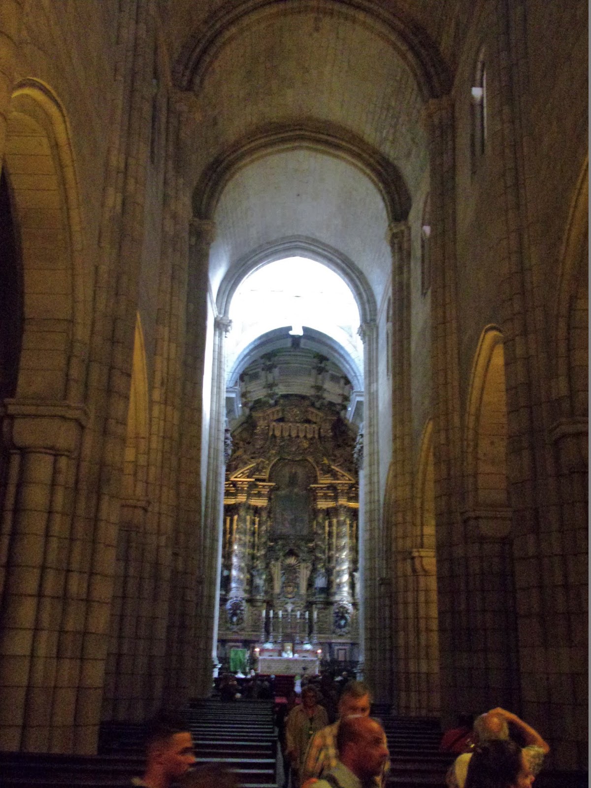
11:14 AM – Porto: Cathedral – view from rear
of nave to main altar in apse.
When
we arrived at the Cathedral, a mass (very small) was going on near the main
altar, and a sign said “Silence – Mass”; so we paid €3 each to visit the
cloister first.


Porto: carimbo stamp from “Fábrica da
Catedral do Porto.”
The
cloister itself was mostly rather
plain, except for the large blue and white azulejo
tile pictures all around the walls of the aisles. However, the admission also
included the Casa do Capitulo (Chapter
House). In the Chapter House, the Treasury
(Tesouro) was nothing great, but the Chapter
Hall and chapels surrounding the
cloister were worth the admission.
In the wing of the Cathedral complex
extending to the south (right) of the naves, and attached to the outer sides of
the cloister, is the Casa do Capitulo
(Chapter House), which contains the
Sala Capitular (Chapter Hall), the Cartório (Notary Chamber), the Sacristia
(Sacristy), and the Capela de São João Evangelista (Chapel of St. John the Evangelist).
The Chapter House was constructed between 1717 and 1719. It replaced an older
Casa do Cabido (House of the Canons, where the canons of the cathedral lived in
community with the bishop) built next to the Cathedral in 1582 and demolished
in 1708.

Porto: Cathedral – Chapter
House exterior, with Cathedral on left and the Chapel of St. John the
Evangelist added on at the right
The first floor of the new
Chapter House was initially planned for granaries to store the wheat and corn
the canons received as revenues from their landholdings; it is divided into
four compartments, covered with vaulted ceilings and interconnected with each
other. The second floor has five rooms, including the Treasury. The third floor
is the “noble floor” (the best part) of the building and has three
compartments: the Ante-Cabido (antechamber, at the top of the staircase that
comes from the cloister), the Notary Chamber, and the Chapter Hall; the
wainscots of the walls are covered with azulejos
representing worldly scenes and hunting, emplaced in 1719-1720.

MT 11:30 AM – Porto: Cathedral – Ante-Cabido (antechamber
of Chapter House) MT with statue of Anjo Gabriel (Angel Gabriel) and child.

11:24 AM – Porto: Cathedral – statue of
Santiago Peregrino (St. James the Pilgrim) in Chapter Hall, with azulejo tiles of hunting scene in
background.

11:24 AM – Porto: Cathedral – Chapter Hall - placard
for statue of Santiago Peregrino (St. James the Pilgrim) in Portuguese,
translates as:
“Santiago
[St. James] – Flemish influence - Beginning of 16th century, with retouches of
the 18th century – Sculpture in the round, in polychromed wood. – Provenance [Origin]
from the chapel of the primitive cloister – cemetery and, subsequently, from
the altar in the interior of the Cathedral.”

11:24 AM – Porto: Cathedral – ceiling of Chapter
Hall (center).
The coffered ceiling of the Chapter Hall in the Chapter House is from
1737. In the Mannerist-style gilded frames of the coffers are 14 allegorical
paintings of moral values and figures of saints. The picture in the center
represents São Miguel (St. Michael), the patron saint and symbolic emblem of
the canons, crushing the devil (not depicted as a dragon, but in human-like
form with the wings of an angel).

11:24 AM (Cropped) – Porto: Cathedral – painting of St. Michael in
center of Chapter Hall ceiling.
The azulejo tile panels of the Chapter Hall were manufactured in
Lisbon, containing hunting scenes.

11:24 AM – Porto: Cathedral – ceiling of Chapter
Hall (right of center).

11:24 AM – Porto: Cathedral – ceiling of Chapter
Hall (left of center).
11:25 AM – Porto: Cathedral – Chapter Hall –
altar, with crucifix, flanked by azulejos.
The gilded altarpiece, with a
polychromed image of the crucified Christ, in the center of the wall in the Chapter
Hall was executed in 1718-1719.

11:26 AM – Porto: Cathedral – Chapter Hall –
candelabra, with crucifix above shuttered window on wall behind it.

11:26 AM – Porto: Cathedral – Chapter Hall -
placard for “Candelabro das Trevas” in Portuguese, translates as:
“Candelabra
of Darkness – Miguel Francisco da Silva / after Nasoni? – 18th century –
Provenance [Origin] from the main chapel [chancel] of the Cathedral.”
After
the Chapter Hall on the third floor of the Chapter House, we emerged onto the southwest
corner of the upper level of the Gothic cloister.

11:27 AM – Porto: Cathedral – Cloister
courtyard from above, near exit from Chapter Hall. This side of the cross at
the top of the column in the center has a figure of the Pietà.
The south transept arm of the
church gives access to the 14th-century Gothic
cloister, the lower level of which is decorated with seven large panels of
Baroque azulejo tiles (between 1729
and 1731) depicting the life of the Virgin Mary and scenes inspired by the Song
of Solomon*, referring to the mystical dialogue between God and the Virgin,
patroness of the Cathedral. A “noble staircase”, completed in 1736 by Nasoni,
gives access to the upper courtyard of the cloister. From that courtyard, with azulejo tile panels with rural and
mythological scenes on its west and south sides, there is a panoramic view.
In the center of the cloister’s
courtyard is a stone cruceiro (crucifix) resting on three
octagonal steps and topped with a Florentine cross. The cross has the crucified
Christ on one face and a Pietà on the other.
*Several sources erroneously
identify the latter as scenes from Ovid’s Metamorphoses.
However, that might apply to some of the azulejo
panels on the walls of the upper courtyard.

11:27 AM – Porto: Cathedral – view of
cathedral towers and south side of nave (with flying buttresses), across top of
cloister courtyard from near exit from Chapter Hall.

11:28 AM – Porto: Cathedral – the two sides (west
and south) of upper cloister with azulejo
panels on walls – viewed from northeast corner.

11:28 AM – Porto: Cathedral – Cloister
courtyard from above, from northeast corner opposite exit from Chapter Hall.
This side of the cross at the top of the column in the center has a figure of
the crucified Christ.
To
visit the Sacristy, we again had to
go down to the lower level of the Cloister.

11:31 AM – Porto: Cathedral – azulejo tile panel on lower level of
cloister near entrance to Sacristy.

11:31 AM – Porto: Cathedral – sign for
entrance to Sacristy.

11:32 AM – Porto: Cathedral – Sacristy - altar
and chests of drawers (for vestments).

11:32 AM – Porto: Cathedral – Another azulejo tile panel near exit from
Sacristy on lower level of cloister.

11:33 AM – Porto: Cathedral – Another azulejo tile panel on lower level of
cloister.

11:33 AM – Porto: Cathedral – Another azulejo tile panel on lower level of
cloister.

11:33 AM – Porto: Cathedral – Another azulejo tile panel on lower level of
cloister.

MT 11:40 AM – Porto: Cathedral – Don with that
azulejo tile panel on lower level of
cloister.
Also
on the lower level of the Cloister was the entrance to the 14th-century Chapel of St. John the Evangelist.

11:34 AM – Porto: Cathedral – sign for
entrance to Chapel of St. John the Evangelist on lower level of cloister.

11:35 AM – Porto: Cathedral – statue of Virgin
and Child in Chapel of St. John the Evangelist.

11:35 AM – Porto: Cathedral – placard for
statue of Virgin and Child known as “Nossa Senhora de Batalha,” in Chapel of
St. John the Evangelist, in Portuguese, which translates:
“Our Lady of the Battle – 14th century – Provenance [Origin] Gate of the ‘Fernandina’ Wall.”
“Our Lady of the Battle – 14th century – Provenance [Origin] Gate of the ‘Fernandina’ Wall.”
The Muralha fernandina (Fernandina Wall), sometimes called by the
plural Muralhas fernandinas (Fernandinas
Walls), was the medieval belt of walls of Porto, of which only small parts now
survive. This is also known as the Cerca Nova (New Wall) or Muralha Gótica
(Gothic Wall), neither of which, although technically more correct, is the most
common name. During the 14th century, Porto had a great urban expansion out of
its original nucleus on the hill around the Cathedral, protected by the Cerca
Vela (Old Wall) that was built on top of the original Roman wall. The new wall
to encompass this wider space was built during the reign of King Fernando I
(ruled 1367-1383), which explains the “Fernandina” name. The wall had several
gates throughout the city, including the Porta da Batalha (Battle Gate)*,
located in the southwest corner of the present Praça da Batalha (Battle
Square), next to what was then the Capela da Nossa Senhora da Batalha (Chapel
of Our Lady of Batalha).** The earliest chapel of that name, just outside the
Fernandina wall, was mentioned as early as 1686, although its origins could go
back to the 16th-century founding of the Confraria de Nossa Senhora da Batalha
(Confraternity of Our Lady of Batalha), which used this chapel as its
headquarters. The construction of a new chapel of the same name began in 1799, on
the same site; the new chapel was expropriated by the Municipality of Porto and
demolished in 1924, to widen the street and make way for a new theater. The
later chapel, and possibly the first, had contained the statue of Our Lady of
Batalha that was originally in an aedicula
(a small shrine in a niche) of the Porta da Batalha and is now displayed in the
Cathedral complex.
Starting in the second half of
the 18th century, when the walls had ceased to be militarily important, they
began to be progressively demolished, to make way for new streets, squares, and
buildings. Most of it had already been demolished in the late 19th century, and
the surviving sections were classified as a National Monument in 1926.
*This gate, also known as the
Porta do Cimo da Vila (Gate of the Top of the Town), was destroyed in 1793.
**According to tradition, the
name of Praça da Batalha (Battle
Square), as well as the gate and chapel, originated from a battle between
Christian inhabitants of Porto and Moors that took place there in the 10th
century (the Christians lost, resulting in the destruction of the city). This
square is where a statue of King Pedro V was erected in 1866.

11:35 AM – Porto: Cathedral – Tomb of João
Gordo in Chapel of St. John the Evangelist.
In the 14th-century Gothic Capela de São João Evangelista (Chapel
of St. John the Evangelist) is the 14th-century sarcophagus of João Gordo, a Knight Hospitaller of the
Order of Malta and former treasurer of the house of King Dinis. He died in
1333, and this chapel for him was built as an annex to the Cathedral. The
chapel is sometimes known as the Capela de João Gordo. Normally, such a
sarcophagus and chapel would have been reserved to royalty and high clerics,
not to a normal citizen, albeit a rich one. This shows the high position and
rank that João Gordo must have had in society at that time. The sarcophagus rests
on the backs of four lions. On its top rests a statue of the knight wearing the
habit and robe of the Knights of Malta, with his sheathed sword at his left
side.
The long side of the sarcophagus
displays the Last Supper. This depiction of the Last Supper is somewhat
curious, since Jesus seems to be holding the figure to the right of him (from
our perspective) in a headlock under his left arm. That figure seems to be
asleep, and something ribbon-like is coming out of his mouth. St. Peter,
holding the keys of the Kingdom, is at Jesus’ right hand. (See note on Last
Supper in Capela de São Vincente, below, regarding the traditional depiction of
John sleeping at the table.)

11:35 AM (Cropped) – Porto: Cathedral – detail
of Last Supper on sarcophagus of João Gordo in Chapel of St. John the
Evangelist.

Porto: Cathedral – detail
of Last Supper on sarcophagus of João Gordo in Chapel of St. John the
Evangelist
The foot end of the sarcophagus depicts
Calvary and Christ’s crucifixion, and the head end the coronation of Mary.
Next,
we came to the Capela de São Vincente.

11:35 AM – Porto: Cathedral – sign for
entrance to Chapel of St. Vincent.
The Capela de São Vincente (Chapel of St. Vincent), from the late 16th
century (1591), is of sober classical architecture. The south transept of the
Cathedral provides access to this chapel, as well as to the cloisters. Along
the side walls, it has remarkable choir seats, from the 17th century, with
Biblical scenes from the Old and New Testaments in bas-relief on the walls
above the seats. On the wall under the organ is a panel of azulejo tiles. Several bishops of Porto are entombed in a crypt
under this chapel.
São
Vincente
(St. Vincent) was the patron saint of the city of Porto between 1025 and 1453. According
to legend, the relics of St. Vincent were passing through Porto as they were
being transported from Lisbon to Braga; when a miraculous intervention of the
saint occurred in Porto, the relics stayed there, and he was declared patron of
the city. In the second half of the 15th century, a group of Armenians had
settled in Porto, seeking refuge after the fall of Constantinople to the Ottoman
Turks in 1453. These immigrants brought with them the relics of the martyr São
Pantaleão (St. Pantaleon, 275-303). The relics were deposited in the Igreja da
Miragaia (Church of Miragaia). The fishing village and parish of Miragaia had
been incorporated into the expanding city of Porto when the Fernandina Wall was
built. When a great plague struck the city later in 1453, the residents of
Miragaia asked St. Pantaleon to protect them. When they were spared, the Bishop
replaced St. Vincent as patron of the city with this Armenian saint, who had
been a doctor, and his relics were moved to the Cathedral. Finally, in 1954,
the Bishop of Porto consecrated the city to Nossa Senhora da Vandoma (Our Lady
of Vandoma).

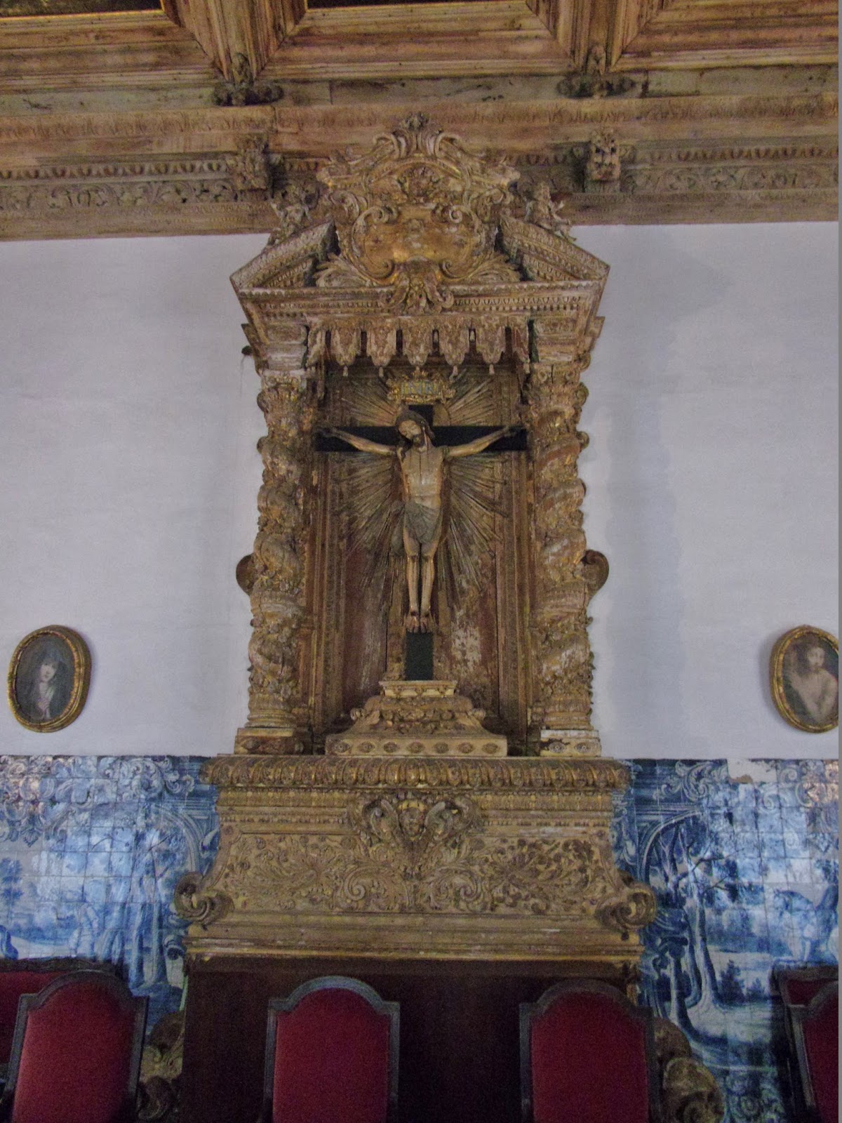
11:38 AM – Porto: Cathedral – Chapel of St.
Vincent - altar with choir seats on left and right walls.

11:39 AM – Porto: Cathedral – Chapel of St.
Vincent - panel above choir bench with polychromed bas-relief of Last Supper (the
disciple at Christ’s right hand is asleep on the table, and the Paschal lamb is
on the platter).
Many early artists’ depictions of
the scene at the Last Supper, just after Jesus has announced his coming
betrayal, show one disciple, usually identified as John, leaning on Jesus’
chest or asleep at the table.

Last Supper, St. Mark’s
Basilica, 13th century (https://en.wikipedia.org/wiki/Last_Supper_in_Christian_art#/media/File:The_Last_Supper_(San_Marco).jpg).
.jpg)

Last Supper by Giotto, 1305
A 14th-century fresco of the Last
Supper by Giotto shows the disciples sitting in quiet and reverent silence,
solemn but calm, so calm, indeed, that one of them—John, the Beloved Disciple—is
asleep, leaning against the chest of Jesus and cradled in his left arm. By
contrast, the disciples in Leonardo da Vinci’s more famous painting of the Last
Supper (late 15th century) are engaged in a heated discussion, except for the
one at Jesus’ right hand, traditionally identified as John, who shares Jesus’
calm demeanor. In Leonardo’s version, some experts say John appears to swoon,
but others say he is leaning to listen to Peter, who is beckoning him to ask
Jesus who it is that will betray him. (Two earlier sketches by Leonardo
followed the more traditional depiction of the scene; one showed John sleeping
with Jesus’ arm resting on his back, and another shows John asleep at the
table. Apparently, Leonardo later decided to have John lean the other way in
order to create more space around the central figure of Jesus.)

Last Supper by Leonardo da
Vinci, 1498
In early depictions of the Last
Supper, the only disciples readily identifiable are Judas (often with his bag
containing 30 pieces of silver visible), John (normally on Jesus’ right side,
usually “reclining in Jesus’ bosom” as the Gospel says*, or even asleep), and
Peter (on Jesus’ left).
*John 13:23: “Now there was
leaning on Jesus’ bosom one of his disciples, whom Jesus loved” (King James
Version); “One of his disciples, the one whom Jesus loved, was reclining at
Jesus’ side” (New American Bible [NAB]). Some scholars believe that the
“leaning” or “reclining” refers to the tradition in ancient times of people
(especially Romans and Greeks) leaning on one’s left arm and lying in a
reclining position rather than sitting when eating, on low couches or cushions,
sometimes arranged around a table. By the time of Jesus, the Roman custom of
reclining on couches at supper had been adopted in some Jewish circles. Matthew
26:20 (NAB) describes Jesus at the beginning of the Last Supper: “When it was
evening, he reclined at table with the Twelve.” According to the Roman and
Jewish custom, the guests approached the table from behind the couches. At the
table, each guest’s position was to recline on his left side with the upper
part of the body resting on the left arm and the head raised; this allowed the
right arm to be free to use for eating. The head of the second guest was
opposite the breast of the first guest, so that if he wanted to speak to him in
secret he would lean upon his breast. The disciple John asked Jesus a question
while in this position at supper. After Jesus had announced that one of the
Twelve would betray him, Peter, probably sitting on the other side of John,
“nodded to him to find out whom he meant” (John 13: 24 NAB), and John “leaned
back against Jesus’ chest and said to him, ‘Master, who is it?’ ” (John 13:25
NAB). Thus, the depiction of John sleeping seems to have come from a misunderstanding
or mistranslation of the Biblical account.

Last Supper, Old St. Peter’s
Church, Strasbourg, circa 1485-1490

Last Supper by Valentin de
Boulogne, 1625-1626

11:40 AM – Porto: Cathedral – Chapel of St.
Vincent - gilded organ at rear of chapel, with azulejo tile panel below and painting of Last Judgement above it
under end of barrel-vaulted ceiling.
After
that, we went back into the nave of
the Cathedral. There was a baptism going on near the main altar. A few minutes
later, we saw another baptism going on by the old baptismal font at the left
rear of the nave.
The Romanesque Cathedral was
constructed in the form of a Latin cross with three naves covered by barrel vaulting. The verticalism of the rather
narrow central nave is accentuated by thick pillars, vaults, and arches. It is
flanked by two aisles (naves) with lower vaults. The interior was also altered
during the Baroque era. In the Chapel of the Holy Sacrament, there is a large,
magnificent silver altarpiece (Altar de Prata), built in the second half of the
17th century and considered a masterpiece of silversmithing. (In 1809, when
Napoleon’s army entered the city, a local resident painted the altar to hide
this silver; the French troops took silver from the Cathedral’s other altars
but never noticed this one and left the silver alone.) Also in the 17th
century, the Romanesque apse (which had an ambulatory) was torn down, and a new
one was built in Baroque style (1606-1610), later decorated with new wall
paintings by Nasoni and choir stalls. The altarpiece of the main chapel (chancel), executed between
1727 and 1729, is an important work of Portuguese Baroque. Above the choir
stalls, there are two organs, the
one on the left from the 17th century and the one on the right from the 19th.

11:43 AM – Porto: Cathedral – main chapel
(chancel) with choir stalls at left and baptism ongoing at main altar.

11:43 AM – Porto: Cathedral – main chapel
(chancel) with choir stalls at left and right and baptism ongoing at main
altar.

11:44 AM – Porto: Cathedral – main chapel
(chancel) with choir stalls at right.

11:45 AM – Porto: Cathedral – silver
altarpiece, with tabernacle, in Chapel of the Holy Sacrament at left front of
nave.

11:45 AM – Porto: Cathedral – rose window at
rear of nave (mild telephoto 35 mm).
The stained glass of the rose window depicts the Assumption of the
Virgin in the center, surrounded by the four Evangelists, with floral motifs
between them.
Then
we went out the portal of the main (west) façade onto the Terreiro da Sé (Terrace of the Cathedral), in front of the
Cathedral.

11:51 AM – Porto: Cathedral – main (west) façade
with rose window, overlooking the Terrace of the Cathedral.
The main (west) façade of the
Cathedral opens onto the Terreiro da Sé
(Terrace of the Cathedral), previously known as Largo da Sé (Square of the
Cathedral), which also houses the Episcopal Palace. The square, as it is today,
is a creation from the 1940s, which necessitated the demolition of several
medieval dwellings and streets in order to build the wide, paved terreiro.

11:50 AM – Porto: Cathedral – Pelourinho do
Porto (Pillory of Porto) on courtyard in front of west façade.
In 1945, the Manueline Pelourinho do Porto (Pillory of Porto),
a symbol of the authority of the local government, was placed here near the Antiga
Casa da Câmara (Old City Hall). The pillory seen today is a reconstruction
based on an engraving of 1797. The original pillory was built at the time of
the granting of the foral (charter)
to the city by King Manuel I in 1517; it was placed in the Ribeira (riverside)
district, in a prominent place on the Fernandina Wall, very close to the
gallows that was also erected there. It was destroyed in the 18th century, as
part of a campaign that extended into the 19th century, of demolishing
monuments symbolic of oppression and despotism. According to ancient
engravings, Porto’s pillory consisted of a beautiful piece of stonework resting
on three stone steps; at the top of the column, which was in twisted form, was
a Manueline crown topped with an armillary sphere (the personal emblem of
Manuel I) surmounted by a weathervane. The column still had an iron rod from
which to hang a lamp that illuminated the pillory at night.
Also
on the Terreiro da Sé, to the left (north) of the cathedral’s west façade, was
a short tower that looked modern, and we had read in Brierley’s notes that that
was the location of one of the Turismo offices in Porto. So we took no photos
of it (although it inadvertently appeared in some photos of the Cathedral).
Later, we discovered that it had some historical significance, as the Antiga Casa da Câmara (Old City Hall).

Porto: Antiga Casa da
Câmara tower, at top of staircase near north tower of Cathedral
.JPG)
The 15th-century Antiga Casa da Câmara (Old City Hall) building,
also known as Torre dos Paços do Concelho (Tower of the Palace of the
Municipality), just north of the Cathedral facade, was built sometime between
1439 and 1443. It was where all council meetings were held from that time and
up to the middle of the 15th century. Prior to that, council meetings were in a
small wooden house called Paço de Arcos (Palace of Arches) constructed in 1360
in the courtyard next to the Cathedral. Like the original building, the new one
was also next to the battlements of the medieval wall around the cathedral. After
structural problems developed in the 16th, the tower was abandoned and fell
into ruin. Between 1795 and 1796, demolition of the house/tower began, because
of danger to surrounding structures, and much of the stone was reused in other
buildings. However, part of the building remained in the 19th century and was
rented out until a violent fire in 1875 left the structure in ruin. Between
2000 and 2002, part of the existing ruins were incorporated into a modern tower,
the same height as the original, with glass and iron lattice, that now houses a
Turismo office. The irregular form of the current building consists of vestiges
of the Old City Hall, with a rectangular contemporary tower over its eastern
edge.

11:59 AM (Cropped) – Porto: Cathedral – view
from front of Cathedral toward Palácio da Bolsa (Palace of the Stock Exchange)
in center, with Igreja de São Francisco behind it and red iron Mercado Ferreira
Borges to its front on the right; Graham’s port wine lodge on hill across Douro
River.
The Igreja de São Francisco (Church of St. Francis) was built between
1383 and 1425, including cloisters for monks of the Franciscan Order. The
general structure of the church has not been extensively altered, making it the
best example of Gothic architecture in Porto. However, it is also noted for its
Baroque interior decoration and main portal, the results of an artistic
campaign in the first half of the 18th century.
A fire, caused by the Siege of
Porto in 1832 destroyed the old cloisters. In the place of the cloisters, the
Commercial Association of the city built the Palácio do Bolsa (Palace of the Stock Exchange), a magnificent
example of 19th-century Neoclassical architecture. Most of the palace was
finished between 1842 and 1850, but the interior was not completed until 1910.
We would visit the Igreja de São Francisco on Tuesday. (See that blog for more photos and notes.)

11:59 AM – Porto: Cathedral – wider view from front
of Cathedral toward Douro River; part of façade of Igreja de São Lourenço at
left.
From
the courtyard in front of the Cathedral, we also had a bird’s-eye view of the Igreja de São Lourenço, below the hill
on which the Cathedral is located, but still above the rest of the city.

12:02 PM – Porto: Igreja de São Lourenço –
façade from ground level.
The Igreja e Convento de São Lourenço (Church and Convent of St.
Lawrence) were built by the Jesuits between 1570 and 1577 in the Mannerist
style (however, the church was not finished until the 18th century, with
elements of Baroque style). The church and convent (monastery) were funded by
donations from the faithful, as well as its founder Frei (Friar) Luís Álvaro de
Távora, who is buried there. However, they were built against strong opposition
from both the Municipal Chamber and the population. Nevertheless, the Jesuits
finally got their much coveted school, which they opened to the community in
1630 to provide free classes and became quite successful.
With the expulsion of the Jesuits
from Portugal in 1759, the church was donated to the University of Coimbra,
until it was purchased by the Eremitas Descalços de São Agostinho (Discalced
Friars of the Order of St. Augustine), who were there from 1780 to 1832. These
friars had come from Spain in 1663, initially settling in Lisbon, at a location
called Lugar do Grilo (Place of the
Cricket). Therefore, the friars were popularly called irmãos-grilos or frades-grilos
(cricket brothers or cricket friars). Therefore, when they took up residence in
the church in Porto, they called it the Igreja
e Convento dos Grilos (Church and Convent of the Crickets). When religious
orders were extinguished in Portugal in 1832, the brothers were forced to leave
the convent. During the Siege of Porto (1832-1833), it was occupied by the
liberal troops of Dom Pedro. The Academic Battalion settled there. By the end
of the siege, the Colégio (school) was ruined and plundered of many of its most
precious possessions, although the austere old Jesuit church escaped
destruction. Since 1834, the premises of the Colégio have belonged to the
Seminário Maior da Sé do Porto (Major Seminary of the Diocese of Porto). It is
now classified as a National Monument.

11:59 AM – Porto: Igreja de São Lourenço – view of bottom part of
façade from terrace in front of Cathedral.
The monumental façade of the church is a mixture of
Baroque and Jesuit Mannerist style. The current façade was completed in 1690. The
façade has two floors, each of which is divided into five vertical bodies. On
the first floor are three doors, of which the one in the middle is framed by
twin Corinthian columns resting on pedestals and surmounted by an interrupted
curved pediment. The other two doors are smaller, with triangular pediments. In
the top part of the first floor are two empty niches and two windows.

11:59 AM – Porto: Igreja de São Lourenço – view of top part of façade from
terrace in front of Cathedral.
On the second floor is the Távora
coat of arms, due to the fact that the church’s founder, a member of that noble
family, is buried inside. On both sides of the section with the coat of arms,
there are empty niches, and above those are windows, with interrupted curved
pediments, that pass completely through the façade. Above those windows are
pyramidal finials. At the top of the central gable of the façade is curved
pediment topped by a Cross of Malta (Frei Luís Álvaro de Távora was also a well-known
Commander of the Order of Malta) on a pedestal. On the sides of the façade are
two bell towers, covered with large scrolls and topped with brick domes.
After leaving the Cathedral area, we headed west to Rua das Taipas and Rua São Miguel
in the Old Town to look for two supposedly cheaper restaurants mentioned in
Brierley’s guidebook. Taipas I Feijao,
in As Siete Maravilhas (The Seven Wonders), was closed until 1 pm (and then
open to midnight), and O Oriente no
Porto (The Orient in Port), which was supposed to be vegetarian, didn’t
even look like a restaurant. So we just headed toward the Ribeira (riverfront)
district to look for an eating place.

MT 12:18 PM – Porto: Don with figures in
window along street.

12:17 PM – Porto: Taipas I Feijao restaurant
with azulejo tiles (in As Siete
Maravilhas).

12:19 PM – Porto: Taipas I Feijao restaurant,
with azulejo tiles, and other
buildings with azulejos and wrought
iron balconies on Rua das Taipas.
We
happened to pass the Igreja da Nossa
Senhora da Vitória.

12:23 PM – Porto: Igreja da Nossa Senhora da
Vitória – façade.
The Igreja da Nossa Senhora da Vitória (Church of Our Lady of the
Victory), on Rua São Bento da Vitória, was rebuilt between 1755 and 1769 to
replace an older church of the same name from 1539 that was built on the site
of the former Jewish Quarter, possibly on the foundations of an old synagogue.
According to some historians, the name given to the church was to symbolize the
victory of the Christian religion over the Jewish. The rebuilt church was badly
damaged by artillery fire during the Siege of Porto (1832-1833) and also by a
fire in 1874 that destroyed the main altar. The simple façade is in the
classical style. The portal with Corinthian columns has an open circular
pediment bearing the coat of arms of the Sousa and Arronches family, to which
the bishop who had it rebuilt belonged. In the center of the upper part of the
façade is a large screened window flanked by two empty niches. In the center of
the tympanum of the triangular pediment is the sun, allusive to the patron
saint.
On
the way toward the riverfront, we passed the Praça do Infante Dom Henrique (Square of Prince Henry) with a
statue of Prince Henry the Navigator, and we also passed Casa do Infante, the
house of his birthplace (where we did not stop).

12:50 PM – Porto: monument of Prince Henry the
Navigator in Praça do Infante Dom Henrique; the large red iron building in
background is Mercado Ferreira Borges marketplace.
The land that now constitutes nthe
Praça do Infante Dom Henrique
(Square of Prince Henry), also known as Jardim do Infante Dom Henrique (Garden
of Prince Henry), formerly belonged to the Convento de São Domingos (Monastery
of St. Domingos). With the abolishing of male religious orders in 1834, the
land was acquired by a commercial association, and several prestigious
buildings, including the Palácio
da Bolsa (Palace of the Stock Exchange), were constructed around the new square that was established in 1885.
The first stone of the monument to Prince Henry the Navigator was laid in 1894,
celebrating the 5th centenary of Henry’s birth. The statue, created in Paris,
was inaugurated in 1900.

12:51 PM – Porto: sign for Monumento ao
Infante D. Henrique (Monument to Prince Henry) with text in Portuguese and English;
English part:
“To
commemorate the 5th centenary of Prince Henry’s birth, the main figure of the
Portuguese Discoveries, this monument was inaugurated in 1900. The statue is of
Prince Henry the Navigator, in battle dress, beside a globe and, symbolically,
pointing overseas.”

12:51 PM – Porto: statue of Prince Henry the
Navigator (telephoto 260 mm).

12:50 PM (Cropped) – Porto: monument of Prince
Henry the Navigator in Praça do Infante Dom Henrique – base of front side with
statue of Victory leading two horses and two Tritons.
There are two sculptural groups
at the base of the monument. One represents the figure of Victory leading two
steeds and two Tritons, to commemorate the triumph of Portuguese navigators.
The other is a female figure symbolizing the Faith of the Discoveries.

Porto: monument of Prince
Henry the Navigator in Praça do Infante Dom Henrique – back side with female
figure at base symbolizing the Faith of the Discoveries
.jpg)
Also at the base are bas-reliefs
depicting the Henry’s capture of Ceuta, on the North African coast, in 1414 and
showing the Prince at the Sagres Promontory, where he established a nautical
school and where he died in 1460.
In
the Ribeira district, we finally stopped at Restaurante Farol da Boa Nova (farol
= lighthouse, boa = good, nova = new or possibly news), and both
of us ordered their special, Bacalhau
Gomes (cod Gomez) for €8.50 each (it was chopped cod with eggs and
potatoes); we also got a 375-ml bottle of Douro red wine (the waiter had told
us it was half a liter, and so did our bill) for €5.90; so our total was
€22.90. (Our bill said “Farol Boa Nova,” and our credit card receipt said just
“Restaurante Farol.”)
Two days later, we would
encounter the actual Farol da Boa Nova
(Lighhouse of Good News), also known as Farol de Leça (Lighthouse of Leça), in
Leça da Palmeira in the municipality of Matosihnos, on the Atlantic coast just
northwest of Porto.

1:07 PM – Porto: Restaurante Farol da Boa Nova
– outdoor seating by front door with full name “Farol da Boa Nova” on sign; our
waiter carrying chair.

12:59 PM – Porto: view from Restaurante Farol da
Boa Nova of cruise boat, shaped like barco
rabelo wine boat, on Douro, with more boats on south bank (mild telephoto
54 mm).

1:07 PM – Porto: view to SE from Restaurante
Farol da Boa Nova of Douro River with Ponte Dom Luís I bridge and monastery on
hill on opposite bank near other end of bridge.

1:05 PM – Porto: Restaurante Farol da Boa Nova
– MT with our wine.

MT 1:11 PM – Porto: Restaurante Farol da Boa
Nova – Don with our wine; Ponte Dom Luís I bridge in background; the label on
the bottle is “Conde de Monsul – Douro DOC - Tinto 2014” (Count of Monsul, Denomination
of the Douro region, vinho tinto = red wine, 2014).

MT 1:52 PM – Porto: Restaurante Farol da Boa
Nova – Don (with hat); Ponte Dom Luís I bridge and monastery in background.

1:06 PM – Porto: view to NW from Restaurante
Farol da Boa Nova through umbrellas. (Note the small chapel behind umbrella in
center and the church with pinnacles to left. They will also show up in a photo
from the south side of the river.)

1:44 PM – Porto: view from Restaurante Farol da
Boa Nova of cruise boat, shaped like barco
rabelo wine boat, on Douro with Viking cruise ship on far bank; on the hill
beyond the ship is part of the Ferreira port wine cellars we would visit
(telephoto 186 mm).

1:51 PM – Porto: view from Restaurante Farol da
Boa Nova of cruise boat, shaped like barco
rabelo wine boat, on Douro with Vila Nova de Gaia on far bank, including
the Sandeman port wine lodge (telephoto 112 mm).

1:51 PM – Porto: view from Restaurante Farol da
Boa Nova of people strolling on Cais da Ribeira (Quay of the Riverside); cruise
boats, shaped like barco rabelo wine
boats, on Douro; Ponte Dom Luís I bridge; monastery on hill; and Vila Nova de
Gaia on far bank.

1:51 PM – Porto: view from Restaurante da Farol
Boa Nova of cruise boats, shaped like barco
rabelo wine boats, on Douro with Vila Nova de Gaia on far bank, including
Cálem port wine cellars at left (mild telephoto 46 mm).
Then
we walked east on the Cais da Ribeira along the Rio Douro toward the Ponte Dom Luís I bridge to head for our
port wine tasting in Vila Nova de Gaia
on the south bank. We crossed the bridge on the lower level, where there was
hardly room to pass people we met on the narrow walkway separated from the
roadway by cast iron guardrails (we decided we would come back on the upper
level, although a considerable climb was required to do so).
The Ponte Dom Luís I bridge is a double-deck metal arch bridge over the
Douro River between the cities of Porto and Vila Nova de Gaia. At its
construction, its arch span of 172 m (564 ft) was the longest of any metal
bridge in the world. The upper deck is 392 m (1,296 ft) long, and the lower is
174 m (571 ft). It is 44.6 m (146 ft) high. It carries a light rail (Metro)
line and pedestrians on the upper deck and general traffic and pedestrians on
the lower deck.

Porto: Ponte Dom Luís I bridge
from north bank
.jpg)
Prior to the construction of this
bridge, foot traffic had to cross a bridge made from old port wine boats lashed
together. When Napoleon invaded in 1809, scores of residents fleeing Porto were
crushed and drowned in the river when a panicked stampede proved too much for
the makeshift bridge.
In 1879, Gustave Eiffel (later of
tower fame) presented a project to build a new bridge over the Douro, with a
single deck to facilitate navigation. That proposal was rejected and, in 1881,
a Belgian firm was awarded the contract to construct a double-deck bridge,
designed by a disciple of Eiffel. The bridge opened in 1886 and was a toll
bridge until 1944.

2:21 PM – Porto: view to west from north end
of Ponte Dom Luís I bridge of Cais da Ribeira on north bank with arcades and cruise
boats on Douro.
The Cais da Ribeira (Quay of the Riverside) district of Porto is located
on the waterfront and in the picturesque city center. The area has a myriad of
medieval narrow streets and narrower alleyways with ancient buildings, some in various
states of decay, renovation, and disrepair. Old homes in multiple pastel colors
stand over the waterfront, and the harbor is filled with typical flat-bottomed boats
(barcos rabelos), from small to
large. This area has been inhabited since the Middle Ages and was once a
bustling commercial and manufacturing district. Many of the buildings around
the main square, Praça da Ribeira, were decimated by a fire in 1491, resulting
in something of an upgrade to the area when it was rebuilt. Now, there are many
fish restaurants, tascas (taverns), and
shops in the old arcades along the quay. In 1996, the Cais da Ribeira area was
named a World Heritage Site by UNESCO.

2:24 PM – Porto: view from south end of Ponte Dom
Luís I bridge of Cais da Ribeira on north bank with arcades and cruise boats on
Douro.
After
crossing the bridge, we were in Vila
Nova de Gaia.

MT 2:35 PM – Vila Nova de Gaia: Don and MT
near south end of Ponte Dom Luís I bridge on Cais de Gaia on south bank of
Douro.
Vila
Nova de Gaia,
or simply Gaia, is a city and concelho
(municipality) in the District of Porto, located south of the city of Porto on
the other side of the Douro River. The city proper has a population of 178,000,
with a total of 302,000 in the municipality. Together with Porto and 12 other
municipalities, it makes up the Porto Metropolitan Area.
Vila Nova de Gaia already existed
in Roman times as the city of Cale. It probably developed from a pre-existing
Celtic castro (hill fortress). The
origin of the name Cale (or Gale, since in Classical Latin there was not always
a clear distinction between the letters “g” and “c”) is likely Celtic. In Roman
times, the bulk of the population probably lived on the south side of the
river, and on the north side there was a smaller settlement around the port
that is now the Ribeira district of Porto. Thus, the name of Porto in Roman and
high medieval times was Portus Cale, meaning that it was the harbor (portus in Latin) of the city of Cale.
With increased trade on the Douro, which was easily navigable deep inland, the
Porto part of the city outgrew Cale and became more important. When the Moors
invaded in the 8th century, the Douro was for a considerable period the de facto border between the Islamic
state and the Christian one. With the constant raids and counter-raids, the
town of Cale, or Gaia, was deserted and most of its inhabitants took refuge in
Porto. With the reconquering of the south side of the Douro after 1035, colonists
from the north resettled the land. These migrants refounded the old city of
Cale or Gaia under the name Vila Nova de Gaia (New Town of Gaia) around the old
castle and ruins of “old Gaia.”
Gaia is well known for its
cellars (locally known as caves), where
the world-famous port wine is stored and aged in “lodges” and warehouses along
the Cais de Gaia (Quay of Gaia). The
Cais is the place where the barcos
rabelos boats transporting wine from the Douro Valley would dock and the
barrels of wine were offloaded and taken to the cellars; it was also where the
port wine was later exported. There are also numerous bars and restaurants
along the Cais. In the alleys uphill are even more port warehouses and
19th-century manor houses.

2:32 PM – Vila Nova de Gaia: barcos rabelos (flat-bottomed boats for
transporting port wine) on Douro, with part of Gaia in background and Ponte de
Arrábida bridge to west.

MT 2:40 PM – Vila Nova de Gaia: barcos rabelos (flat-bottomed boats for
transporting port wine) on Douro, with part of Cais da Ribeira on north bank in
background and Ponte de Arrábida bridge to west.

2:33 PM – Vila Nova de Gaia: barcos rabelos (flat-bottomed boats for
transporting port wine) on Douro, with part of Cais da Ribeira on north bank
and Ponte Dom Luís I back to east.

2:33 PM – Vila Nova de Gaia: barcos rabelos (flat-bottomed boats for
transporting port wine) on Douro, with part of Cais da Ribeira on north bank;
from here, the Torre dos Clérigos in the center of Porto is visible on the
horizon in the distance, to right of photo center; Cathedral to its right,
nearer.

MT 2:42 PM – Vila Nova de Gaia: barcos rabelos (flat-bottomed boats for
transporting port wine) on Douro, with part of Cais da Ribeira on north bank;
from here, the Torre dos Clérigos in the center of Porto is visible on the
horizon in the distance, at photo left; Cathedral to its right, nearer.

2:35 PM – from Vila Nova de Gaia: view of part
of Cais da Ribeira on north bank, including small chapel Capela da Nossa
Senhora do Ó (lower right) and rear view of Igreja de São Nicolau (upper left
with pinnacles) just to west of Restaurante Farol da Boa Nova (telephoto 186
mm).
The small chapel is Capela da Nossa Senhora do Ó (Chapel of
Our Lady of the O), in the heart of the Ribeira district. Previously called the
Capela da Nossa Senhora da Piedade (Chapel of Our Lady of Piety [or the Pietà]
or Capela da Nossa Senhora do Cais (of the Quay), it dates from the 17th century.
The current name comes from the fact that the statue of Senhora do Ó, a
pregnant Virgin, was transferred here when the Capela da Porta da Ribeira
(Chapel of the Port of the Riverside) was demolished in 1821. The current
chapel was remodeled in the 19th century due to damage it suffered in the
Liberal Wars. The main façade has a central door with a window on each side and
another one over the niche with the image of the Virgin above the door. All
three windows are barred and ornamented. Nowadays, the chapel is not normally
open to the public.

2:35 PM – view from Vila Nova de Gaia of Capela da Nossa Senhora do Ó
facing Cais da Ribeira on north bank (telephoto 186 mm, cropped).
Nossa
Senhora do Ó
(Our Lady of the O) is a title of the Virgin Mary that arose in Spain in 656
when the 10th Council of Toledo stipulated that the Feast of the Annunciation
be transferred to December 18. Shortly thereafter, this feast began to be
celebrated with the title Expectação do Parto da Beatíssima Virgem Maria (Expectation
of the Birth of the Blessed Virgin Mary), and vespers on the eve of the feast
would be initiated by reciting the seven antiphons that begin with “Oh!” (the
“O antiphons”). Thus the people came to call this ceremony Our Lady of the O.
The Igreja de São Nicolau (Church of St. Nicholas) is on the site of a
small hermitage of the 13th century that was demolished to make room for the
larger church in 1671. After a fire in 1758, the church was reconstructed in
1762 in a mix of Neoclassical and Baroque styles. The façade was covered with azulejo tiles in 1861.

Porto: Igreja de São
Nicolau – façade with pinnacles
#/media/File:Igreja_S_Nicolau_(Porto).JPG)

Porto: Igreja de São
Nicolau – façade and side with pinnacles
#/media/File:Porto_-_Igreja_de_S%C3%A3o_Nicolau_(2).jpg)

2:35 PM – Vila Nova de Gaia: barcos rabelos (flat-bottomed boats for
transporting port wine) on Douro, with part of Cais da Ribeira on north bank;
from here, the Torre dos Clérigos and the Cathedral are on the horizon to right,
and the small Capela da Nossa Senhora do Ó near Restaurante Farol da Boa Nova
is around the center.

2:42 PM – Vila Nova de Gaia: sign for Francesinha. (At lunch, after we had
ordered, MT had asked our waiter what a man at the table next to us had, and he
told her it was this; it resembled a sandwich-like calzone.)
A Francesinha (meaning Little Frenchie) is a
Portuguese sandwich originally from Porto. It is made with bread, wet-cured
ham, linguiça (smoke-cured pork
sausage), a fresh sausage like chipolata
(fresh pork sausage), and steak or roast meat and covered with melted cheese
and a hot, thick tomato and beer sauce; it is served with french fries or on a
bed of chips doused in the famous Francesinha
sauce. It is said to have been invented in the 1950s or 60s by a Portuguese
emigrant returning from France or Belgium, who tried to adapt the croque-monsieur to Portuguese taste.
Other sources date it to the 19th century. It is a very popular dish in Porto,
although sometimes found elsewhere in Portugal.

2:46 PM – Vila Nova de Gaia: Ferreira port
wine cellars – exterior, with entrance in first of several similar buildings.
We
got to the Caves Ferreira (Ferreira Wine Cellars) around
2:45 pm and asked if we could take an earlier tour, but they said that the
English tour was at 3:30 (when we had our reservation). Don noticed that his
new (cheap) watch had stopped at 3 pm, but when he reset it, it started again
(and is still running).

2:47 PM – Vila Nova de Gaia: Ferreira port
wine cellars – sign by entrance in Portuguese and English; English part:
“With
over 250 years’ tradition, the first references to Ferreira date back to 1751,
when a Douro winegrowing family began producing high quality Porto Wines.
“Ferreira
owes much to the contribution of D[ona] Antónia Adelaide Ferreira, the
legendary figure who became a symbol of the entrepreneurship in Douro viniculture
as well as an example of altruism and generosity towards the needy.
“Visiting
Ferreira today is to pass through years of tradition and knowledge, in an
historical legacy that Ferreira is proud to share with its visitors.
“OPENING
HOURS ALL YEAR – EVERYDAY; 10 AM-12:30 PM|2 PM-6 PM”
Dona
Antónia Adelaide Ferreira (1811-1896) was a 19th-century Portuguese
businesswoman known for her leadership in the cultivation of port wine and for
the winemaking innovations she introduced to Portugal. She inherited many
vineyards from her wealthy family, themselves heirs of the winegrowing
tradition of the Ferreira da Régua. Assuming management of the company, she fought
against the lack of support by the Portuguese government for local viniculture,
during a time when much Portuguese wine was imported from Spain. She traveled
to England to learn the best techniques to battle the phylloxera disease that
was destroying European grapes, including those in Portugal and her own
vineyards. In England, where she stayed for 3 years, she also learned new
processes for wine production. Back in Portugal, she invested in many new
vineyards, while maintaining the original vineyards she had inherited in
northern Portugal. Most of her wine was exported to England, the first major
importer of port wine, and for many years she was the largest exporter of port.
She is considered one of the leaders in the history of the Douro Valley and an
influence on the continued popularity of Portuguese wines. She received the
nickname “Ferreirinha” (an affectionate diminutive of her family name) for her
devotion and care of the working families who farmed her lands and vineyards,
especially in the hard times caused by phylloxera, bad harvests, or falling
prices. She also founded a hospital in her hometown of Régua and was
responsible for other important social work in the region.
The
tour was very interesting and wound
through many parts of the (above-ground) cellars.
Vinho do Porto (Port wine), or
usually called simply port, is a
fortified wine produced exclusively in the Douro Valley in the northern
provinces of Portugal. It is typically a sweet, red wine, often served as a dessert
wine, although it also comes in dry, semi-dry, and white varieties. After a few
days of fermentation, until the alcohol levels reach around 7%, the young wine
is fortified with brandy to bring the fermentation process to a sudden stop,
capturing the young wine’s fruit nuances and preventing the grape sugars from
continued conversion to alcohol.
Aged tawny port is made from red grapes that are aged in wooden (oak) barrels
exposing them to gradual oxidation and evaporation, which results in its
mellowing into a golden-brown color. Aged tawny ports are sweet or medium dry.
They are categorized by the number of years spent in the barrels: 10, 20, 30,
or over 40 years. Since tawny port is typically a blend of older vintage wines,
the age indicated on the bottle is an average of the various vintages used in
the tawny blend.
Ruby
port
is the cheapest and most extensively produced type. After fermentation, it is
stored in tanks made of concrete or stainless steel to prevent oxidative aging
and preserve its rich claret (ruby red) color. Ruby port is aged, in bottles, for
3 years and does not generally improve with further aging.
White
port
is made from white grapes and can be made in a variety of styles, ranging from
dry to very sweet. When white ports are matured in wood for long periods, the
color darkens, eventually to a point where it can be hard to tell it (from
appearance alone) whether the original wine was red or white. Ordinary white
ports make an excellent basis for a cocktail, while those of greater age are
best served chilled on their own.

3:10 PM – Vila Nova de Gaia: Ferreira port wine cellars
– large wooden vats (for ruby port), near the area where the tour would begin,
and some smaller barrels (for tawny port) at the far end.

3:10 PM – Vila Nova de Gaia: Ferreira port wine cellars
– smaller barrels (for tawny port) at left and large wooden vats (for ruby port)
at right, in the area where the tour would begin.

MT 3:40 PM – Vila Nova de Gaia: Ferreira port
wine cellars – our guide with small barrels (for tawny port) and large vat (for
ruby port) - vertical.

3:41 PM – Vila Nova de Gaia: Ferreira port wine cellars
– our guide with small barrels (for tawny port).

3:52 PM – Vila Nova de Gaia: Ferreira port wine cellars
– guide showing us a “museum” of bottles of the oldest port wines, with special
ones marked with the year of the vintage on oval signs.

3:56 PM – Vila Nova de Gaia: Ferreira port wine cellars
– “museum” of the oldest port wines, with oval signs marking oldest ones,
including “1815,” 1850,” and “1847.”
Dona Antónia Adelaide Ferreira personally
accumulated around 13,000 barrels of vintage port and created a precious wine
cellar of the most renowned harvests, such as 1815, 1820, 1834, 1847, 1857, and
1863, ensuring Ferreira’s heritage for many generations to come. Porto Ferreira
Vintage 1815 honored the Duke of Wellington’s military victory over Napoleon
and was nicknamed the “Waterloo Vintage.”
At
the end of the tour was the port wine
tasting. We each got two glasses of port: one white port and one 4-year-old
tawny. We sat at a table with two Canadian couples.

3:58 PM – Vila Nova de Gaia: Ferreira port wine cellars
– wine-tasting table where we sat with Canadians; we each got two glasses.

3:58 PM – Vila Nova de Gaia: Ferreira port wine cellars
– MT taking photo of her glasses at wine-tasting; Don’s glasses in foreground.

MT 4:05 PM – Vila Nova de Gaia: Ferreira port
wine cellars – MT’s glasses at wine-tasting.
After
the wine tasting, we began to walk back east along the Cais de Gaia (Quay of Gaia) toward the Ponte Luís I bridge.

4:13 PM – Vila Nova de Gaia: view to north, with
part of Cais da Ribeira on north bank and Porto skyline.
Before
approaching the bridge, we stopped at Mamma
Maria – Gelateria Artigianale Italiana, artisan ice cream shop on the Cais
de Gaia, and we each got one bola
(dip, but had two scoops); MT got chocolate chip and Don fragola (strawberry) for €2 each.

4:44 PM – Vila Nova de Gaia: Mamma Maria –
Gelateria Artigianale Italiana exterior.

4:40 PM – Vila Nova de Gaia: Mamma Maria –
Gelateria Artigianale Italiana interior, by our table.
As
we continued toward the bridge, we passed the Capela de Nossa Senhora da Piedade (Chapel of Our Lady of the Pietà).

4:47 PM – Vila Nova de Gaia: MT in front of
Capela de Nossa Senhora da Piedadeon Cais da Gaia with azulejo-covered façade and figure of pietà in niche over door.

4:48 PM – Vila Nova de Gaia: on Cais da Gaia,
view toward upper level of Ponte Dom Luís I bridge and monastery on hill, with
gondolas above Cálem port wine lodge.
To
catch the Metro (Orange or D Line) back toward our hotel, we had to climb steeply up to the top level of
the Ponte Dom Luís I bridge.

4:57 PM – Vila Nova de Gaia: signboard on the
long climb up to the top level of the bridge.

5:00 PM (Cropped) – Vila Nova de Gaia: view from
top, near bridge, of Vila Nova de Gaia (left), Douro River, and a bit of Gaia
da Ribeira of Porto (right).

5:00 PM (Cropped) – Vila Nova de Gaia: view from
top, near bridge, of a bit of Vila Nova de Gaia (left), Douro River, and Gaia
da Ribeira of Porto (right), with Torre dos Clérigos on horizon.

5:00 PM (Cropped) – Vila Nova de Gaia: view from
top, near bridge, of Gaia da Ribeira of Porto, with Torre dos Clérigos on
horizon, and Ponte Dom Luís I bridge (right).

5:00 PM (Cropped to Vertical) – Vila Nova de
Gaia: view from top, near bridge, of Gaia da Ribeira of Porto, with Torre dos
Clérigos on horizon, towers of Cathedral to its right, and Ponte Dom Luís I
bridge (far right).
The
Metro station was near the Mosteiro da
Serra do Pilar.

5:00 PM – Vila Nova de Gaia: view from top, near
bridge and Metro station, of the round church of Mosteiro da Serra do Pilar
(mild telephoto 46 mm).
The Mosteiro da Serra do Pilar (Monastery of the Serra do Pilar), also
known as Mosteiro de Santo Agostinho da Serra do Pilar (Monastery of St.
Augustine of the Serra do Pilar) is located on an elevation called Serra do
Pilar (Mountain of Pilar) overlooking the Douro River, on the south side
opposite the city of Porto. It was a male monastery belonging to the Order of
St. Augustine. Its construction began in 1538 and lasted for centuries, with
several stages of construction that significantly altered the original design.
The church was classified as a National Monument in 1910 and as a UNESCO World
Heritage Site in 1996.
Originally, the monastery was
called Mosteiro do Salvador do Porto (Monastery of the Savior of Porto),
dedicated to Christ, but it has had several different names. The current name
originated in devotion to the Virgin of Pilar in the time of the Philippine
(Hapsburg) dynasty (1580-1640), when Portugal was under Spanish rule; this led
to the adoption of a Spanish saint for the monastery. According to some
sources, the statue of the Virgin of Pilar was placed in the main chapel of the
monastery in 1678.
The building of the original
monastery began in 1538, with the early church dedicated in 1544. Already in
1597, the construction of a new, larger church was begun, using some elements
of the first church; due to lack of funding and political turmoil, this
building would not be finished until between 1669 and 1672.
The privileged geographic
position (overlooking the Douro River, Vila Nova da Gaia, and Porto) gave the
monastery military significance during the French invasions (1807-1814) and the
Siege of Porto (1832-1833), leading to the construction of a fortified system.
In 1835, one year after the decree abolishing male religious orders in
Portugal, the site was taken over by the Portuguese government and was elevated
to the status of a Praça de Guerra de 1a
classe (1st-class War Plaza). Wars that occurred over the years left
several buildings ruined. The monastery was used for military barracks in the
early 20th century, and in 1927 reconstruction was begun. It was finally opened
to worship in 1957, and further reconstruction began at the end of the 20th
century. Architecturally, the monastery complex has elements of Renaissance and
Mannerist styles. It is a unique example of a monastery in which the church
part is round with a dome (a replica of the Church of Santa Maria Redonda in
Rome), and the cloister is also circular.
At
the Jardim do Morro (Garden of the
Hill) Metro station, we needed €3 in
coins to pay the fare (the Turismo had told us to use Zone 2) and had to get
change for a €5 note from some Belgians (who luckily spoke German).
For
€1.85 each, we rode the Metro to the Trinidade station, where we transferred to
another line (in the direction of Campanha and Estádio do Dragão) to the Campo
24 Agosto station, which was just across a small park from Hotel Vila Galé, where we arrived around 6 pm.
No comments:
Post a Comment