This post is based primarily on
Don's notes, occasionally supplemented with MT's notes from our Camino in 2016.
When information from other sources is added—for further explanation to readers
or to satisfy our own curiosity—that is set off in a text box (as this one).
Most of the photos that accompany
this post are from Don’s camera (with a caption indicating the time it was
taken); those from MT’s iPhone are indicated by “MT” placed at the beginning of
the photo caption. Photos from any other source (such as the public domain
Wikimedia Commons) indicate that source in the caption.
We
ate breakfast at Café Rédea Curta:
toast with tomatoes and onions (and oil?); both had a sliced orange; MT coffee
and milk/Don water.
Ivana
walked with us a few blocks to the Camino route on Rua Dom João IV. She had
told MT that, if we made it as far as a town (starting with A) just before a
dark forest, she could drive us the rest of the way to Tomar (or just take us
to Tomar from Golegã).

Thursday, September 1, 2016, 11:06 AM – After Golegã: olives on tree.

MT 11:12 AM – After Golegã: olives on tree (closer up).
5.6
km out of Golegã, we came to the village of São Caetano.

11:19 AM – São Caetano: sign entering town, with
MT in background.

11:24 AM – São Caetano: yellow arrow on utility
pole (we turned right).

MT 11:30 AM – São Caetano: official Camino sign
with scallop shell and yellow arrow, with snails at bottom.
Next,
we came to the village of Vila Nova da Barquinha.

11:57 AM – Vila Nova da Barquinha: welcome sign
entering town and apparently the “concelho” (municipality).
Vila
Nova de Barquinha
is a town (pop. 7,322) that is the seat of a concelho (municipality) of the same name (pop. 3500), still in the
district of Santarém. It belonged to the old province of Ribatejo. The village
of Vila Nova da Barquinha was created in the 17th century around a river port
(hence the name Barquinha, from barca
(boat), meaning little boat). In the 18th and 19th centuries, the village
became the most important in the region, and it was turned into the seat of the
municipality in 1836 (formerly in Atalaia). The arrival of the Portuguese
railway system eventually led to the decline of riverboat commerce in the
municipality.
Although some villages in the
municipality are ancient, the development of the region is closely related to
the period of the Reconquista, when
the River Tagus (Tejo), which flows through the municipality, was the border
between the dominions of Christians and Moors. In the 12th century, the Knights
Templar were in charge of the defense of this border, and they built castles
along the river. In the late 13th century, when the Reconquista was finished, the importance of these castles declined,
but the villages along the river became important river ports for the transport
of agricultural goods of the region to Lisbon.
The second oldest bullring in
Portugal, built in 1853, is next to the train station of Vila Nova da
Barquinha. It is the scene of at least one Corrida
de Touros (Running of the Bulls) each year.

MT 12:02 PM – Vila Nova da Barquinha: – prickly
pear cactus.

MT 12:16 PM – Vila Nova da Barquinha: – a kind of
evergreen tree MT liked.
Shortly
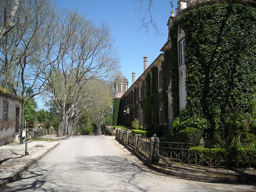
after Vila Nova da Barquinha, we came to Quinta
da Cardiga, which was very large and impressive, although not well kept up.
Unfortunately, Don was in a hurry to find a place to go to the bathroom; so he
took no photos—and neither did MT.
The Quinta da Cardiga is an old manor house on land that was given to
the Knights Templar by King Dom Afonso Henriques in 1169, for land clearing
and cultivation. However, shortly thereafter the Templars erected a castle
there, known as Castelo da Cardiga (Castle of Cardiga). Strategically located
on the banks of the River Tejo (Tagus), this castle—along with the castles of Almourol,
Ceras, and Zêzere—became part of the defensive system, known as the “linha do
Tejo” (Tagus line), against invasion by both the Spanish and the Arabs.
With the extinction of the
Knights Templar in 1312, the land and the castle passed to the Ordem do Cristo
(Order of Christ) in 1321. That order then built a summer farm (c. 1540-1542).
The project included a palace, a barn, a chapel, and a cloister. This complex
became a quinta (farm) in the
municipality of Golegã, with the great house with garden, vegetable garden,
chapel, stables, barns, houses for servants, hospices, mill, wine cellar, and
other workshops and facilities. The architectural ensemble is an interesting
mixture of styles, with a tower (from the original castle), a Manueline portal
of the 16th century, and azulejo
tiles from the 16th and 17th centuries. Thus, the quinta, expanding from the castle, became a royal palace, home to
religious orders, hospital for pilgrims, and home to nobility.
With the extinction of religious
orders in Portugal in 1834, the property passed into the hands of many
individuals. Since the 19th century, the quinta
has been owned by several large farmers, but it is now abandoned. In fact, it
was listed for sale in 2016 on Sotheby’s International Realty’s web site.
The web site http://www.sothebysrealtypt.com/imoveis/quinta-30-quartos-golega-golega_pt_10580 includes
several good photos of the buildings and grounds and provided the following
information: Sale price – under consultation; 30 rooms, Área bruta ([raw?]
area) 22,297 m2 (240,003 sq ft), Área Terreno (terrain area) 422,400
m2 (4,549,676 sq ft or 104.38 acres); description (in Portuguese,
translated): “Romantically situated to the north of Lisbon, Quinta da Cardiga
has been a grand family house with an equestrian center with a century of
existence. Quinta da Cardiga was donated to the Templars by Dom Afonso
Henriques. A part of the quinta is
more than 850 years old.”

Quinta da Cardiga:
palace with circular tower and thin circular chimneys; stone bridge at far end
of road (http://farm5.static.flickr.com/4064/4513895993_dab3013034.jpg).
The palace has the structure of a Renaissance palace-fortress flanked by circular towers topped by cupolas. It integrates interior courtyards, galleries, and several outbuildings.

Quinta da Cardiga:
courtyard with fountain (http://farm1.static.flickr.com/44/130214046_83f665e305.jpg).
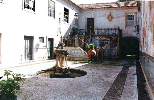
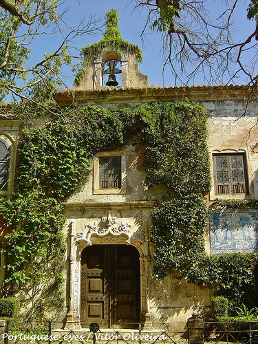
The main façade is marked by the symmetrical arrangement of windows on two floors. The Manueline main portal has a simple rectangular frame surmounted by a pediment with winding elements into which is inserted a medallion with the Cross of Christ (emblem of the Order of Christ) supported by two putti. The main façade also has a scalloped portal decorated with grotesque motifs.

Quinta da Cardiga:
Manueline door with bell gable above an azulejo
panel at right (http://farm8.static.flickr.com/7199/6876917531_257c077ee1.jpg).

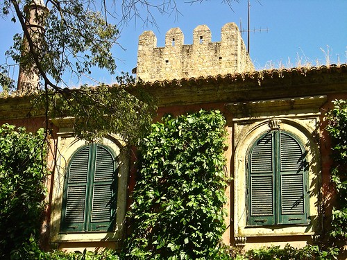
Quinta da Cardiga: palace
and top of castle tower (http://farm4.static.flickr.com/3172/3055307189_0604732078.jpg).
From the Templar castle, there remains a quadrangular tower with six floors. The quadrangular barn is covered with vaults based on monolithic columns. The Chapel, dedicated to Nossa Senhora da Misericórdia (Our Lady of Mercy), has a single nave with a square chancel covered by a vault.
Then
we came to the village of Atalaia.

MT 12:26 PM – Vila Nova da Barquinha: Don behind wall with cut-out of person.

12:27 PM – Atalaia: sign entering town; the
town’s crest features a tower (since, in Portuguese, atalaia means watchtower); “Saúda-vos” means “Greetings to you.”
Atalaia (pop. 1,735) is
a freguesia (civil parish) in the concelho (municipality) of Vila Nova da
Barquinha. Between 1213 and 1836, Atalaia was the seat of the municipality. In
2007, a group of scientists found traces of human (Neanderthal) occupation,
dating back over 300,000 years, at the site of Ribeira da Atalaia (riverbank of
Atalaia); these are the oldest remains known in Portugal. In Portuguese, atalaia means watchtower.

12:47 PM – Atalaia: Igreja da Atalaia (aka Igreja
Matriz de Atalaia) – façade and tower.
The Igreja da Atalaia (aka Igreja
Matriz de Atalaia), the main church of Atalaia, was built between 1514 and
1528 and dedicated to Nossa Senhora da Assunção (Our Lady of the Assumption);
hence it is also known as Igreja Matriz
de Nossa Senhora da Assunção. Its architecture includes elements of
Renaissance, Mannerist, and Baroque, with some points of Gothic origin. It has
a magnificent portal in the Manueline style (see Appendix A of this blog). The
curious façade is divided into 5 parts, of which the two parts on the sides
have curves at the top with curved arches for passage. The corners of the
church are topped with buttresses crowned by pinnacles. The central body of the
façade is distinctive, having 4 levels; the first with the main portal, the
second with a perspectival window, and the last 2 making up the bell tower. The
current façade does not match the original building, since it was much altered
by the restoration carried out in the 1930s. The church has been a National
Monument since 1926.

Atalaia: Igreja da Atalaia
- portal (pt.wikipedia.org).
The element that deserves the most interest is actually the portal, whose composition has 2 pilasters, with niches that house the figures of St. Peter and St. Paul, framing a round arch surmounted by an entablature full of grotesque motifs that flank the coat of arms of Pedro de Meneses (the Count of Cantanhede, who built the church in 1528). Around the top of the portal are 4 carved busts: 2 on each side of the arch, with the figures of a young man and a warrior; the other 2 at the base of the pilasters, showing a man and a woman.

Atalaia: Igreja da Atalaia
- detail of upper right corner of portal showing medallion of warrior and
figure of St. Paul (pt.wikipedia.org).
The interior is in the Renaissance style, divided into 3 naves. The tops of the walls of the central nave are decorated with azulejo tile panels, from the early 17th century, depicting scenes from the Old Testament.

1:12 PM – After Atalaia: path through eucalyptus
forest; at right are a wooden yellow arrow and a sign for “Área de Refúgo de
Caça” (Area of Refuge of Hunting).

1:12 PM (Cropped) – After Atalaia: wooden yellow
arrow and a sign for “Área de Refúgo de Caça” (Area of Refuge of Hunting) on
path through eucalyptus forest.

MT 1:19 PM– After Atalaia: eucalyptus trees.
We
came to a place where the smooth dirt path we were on continued straight and
then curved around a corner to the right. However, before the curve, someone
had painting several rocks created a large yellow arrow that pointed off to the
right, perpendicular to the smooth path. We didn’t like the looks of the path
to the right (rough and uphill); so we continued for a bit straight and around
the curve, but saw no more arrows. Then we had to go back and take the turn
uphill.

1:29 PM – After Atalaia: MT at place where
smooth path continued straight and around curve, but large yellow arrow pointed
to right.

1:29 PM – After Atalaia: MT studying large
yellow arrow that pointed to right, uphill.

1:29 PM – After Atalaia: rough path uphill.
This
was only the beginning of several hills. Every time we thought we had reached
the top of the climb, there was another, larger hill ahead. Brierley’s map
showed we had to climb one medium-size hill and two large hills (MT thought it
was four).

1:31 PM – After Atalaia: Don on narrow, rocky
path uphill (telephoto 54 mm).

1:32 PM – After Atalaia: Don on first plateau on
steep climb (telephoto 64 mm).

1:32 PM – After Atalaia: Don on first plateau on
steep climb (no telephoto).

1:33 PM – After Atalaia: Don taking a water
break on first plateau on steep climb.

1:38 PM – After Atalaia: MT going on uphill;
yellow wooden arrow nailed to tree stump.

1:39 PM – After Atalaia: MT on small plateau
partway up this hill.

1:39 PM – After Atalaia: MT at plateau and path
going on up (telephoto 360 mm).

1:41 PM – After Atalaia: MT at top (of this
part).

1:41 PM – After Atalaia: MT at top (of this
part) (telephoto 186 mm).

MT 2:00 PM – After Atalaia: another large yellow
arrow made up of painted rocks.

MT 2:01 PM – After Atalaia: just past that
yellow arrow made up of painted rocks, Don with fallen yellow stake with broken
wooden yellow arrow (he pounded the stake back into the ground so the remaining
part of the arrow pointed to the path ahead, as did the rocks, but he kept the
other part of the arrow as a souvenir).
After
several more hills, we finally came to the small village of Grou. Grou is Portuguese for crane (the bird).

2:43 PM – Grou: MT on road entering Grou;
utility [pole has spray-painted yellow arrow (above it are sign for Hostel and
another sign with scallop shell an yellow arrow); on left side of road ahead is
a parked SUV with 2 ladies behind the open rear door.
At
Grou, we greeted two middle-aged
Portuguese ladies by a vehicle on the street, and one of them offered us water
from her fuente (literally a
fountain, but just a spigot on the side of an outbuilding) and then gave us two
nice apples. (Total stop 10 minutes.)
Then
we stopped at a bar in Asseiceira
and got ice cream bars (€1.10 ea).

3:08 PM – Asseiceira: sign entering town, and town
and church in background.
Asseiceira is a town that
is the seat of the freguesia (civil
parish) of the same name in the concelho (municipality) of Tomar. It was a
village and seat of a concelho
between 1253 and the beginning of the 19th century. In 1801, it became the seat
of a freguesia. The freguesia, which includes Grou, has a
population of 2,945. The name Asseiceira is derived from the Latin word that
became salgueiral (willow) in
Portuguese, and it is considered the “pérola
do concelho de Tomar” (pearl of the municipality of Tomar), since it was
located on the Roman road and was a frequent resting place for travelers. In
the 13th century, Asseiceira belonged to the Knights Templar and was protected
by the knights in Tomar.
Then
we stopped (15 minutes) at a Mini Mercado in Asseiceira to buy 1.5 liter bottle
of water (€0.50), 2 bananas (€0.29), and ¼ kg of Queijo Alavo cheese (€1.57;
the lady sliced it for us) for a total of €2.36 with tax.
Down
the street, we stopped (3:55-4:03) to eat the cheese, MT’s banana, and drink
the cold water.
Around
4:15, we reached the village of Guerreira.

4:16 PM – Guerreira: sign entering town.
At
the Glorieta junction, we saw an
arrow for right turn, but the streets went either straight ahead or to the left
(with a yellow X meaning not to go there). So we tried going straight but saw
no more arrows; then we went back to the intersection, where a young man told
us that we were still many kilometers from Tomar and suggested we go to the
nearby train station. Near the train station, we stopped at Estação (Station)
bar, and the men there told us to try going straight from the questionable
intersection. Just after that intersection, having crossed to the sidewalk on
the righthand side of the street earlier than we had before, we found a faint
yellow arrow on the sidewalk pointing to turn right onto a narrow dirt path
that did not look inviting.
At
that point, we were so tired (from all this walking back and forth, after a
long day on the Camino) that we went back to the train station to get someone to call a taxi for us (this was around
5:30, and we were still a long way from our hotel). When we entered the
building pointed out as the station, we found a furniture store on the ground
floor (the station was upstairs) and two sales ladies who spoke no English. We
finally got them to call a taxi, after one of them had reluctantly looked it up
in the phone book.
The
taxi came after a long time and charged €10 to take us to our reserved lodging
at Pensão Residencial União. The driver told us that the temperature that day
was 40° C (104° F) and that the week ahead was
supposed to be up to 42° C (107.6° F).
Thus,
we finally arrived in Tomar.
Tomar (also known in
English as Thomar) is a city and the seat of a concelho (municipality) of the same name in the Santarém district.
The city has a population of about 20,000 and the municipality 40,677.
The city lies over the old Roman
city of Sellium. After the retaking of the region from the Moors in the
Portuguese Reconquista, the land was
granted to the Order of the Knights Templar in 1159. In 1160, Gualdim Pais, the
Grand Master of the Templars in Portugal, laid the first stone of the castle and
monastery (Castelo de Tomar/Convento de Cristo) that would become the
headquarters of the Order in Portugal. From it, the Templars ruled a vast
region of central Portugal, which they pledged to defend from Moorish attacks
and raids.
In 1162, Gualdim Pais as Grand
Master also granted the foral (feudal
charter) to the town of Tomar.* Tomar was the last Templar town to be
commissioned for construction. When the town was founded, most of its residents
lived in dwellings located inside the protective outer walls of the Castle of
Tomar.
* The Portuguese word foral is derived from the Latin forum. A carta de foral, or simply foral,
was a royal document in Portugal, whose purpose was to establish a concelho (council) and regulate its
administration, borders, and privileges. A newly founded town would also need
the king’s approval, through a foral,
in order to be considered one. Thus, the granting of the foral was the most important event of a town’s or city’s history.
The foral made a concelho free from feudal control, transferring power down to the
local concelho, with its own
municipal autonomy. As a result, the population would become directly and
exclusively under the dominion and jurisdiction of the crown, excluding the
feudal Lord from the power hierarchy. The pelourinho
(pillory) is directly linked to a foral.
It was erected after the foral was
granted and placed in the main square of the town.
In 1312, heavily swayed by Philip
IV of France, Pope Clement V (papacy 1305-1314) issued a papal bull abolishing
the Knights Templar throughout France and most of Europe on charges of heresy. Pope
Clement V wanted the Templars banned throughout Europe. However, King Dinis I
of Portugal refused to pursue and persecute the former knights and defended
them, largely for their aid during the Reconquista
and the subsequent reconstruction of Portugal. Dinis simply rebranded the Order
of Knights Templar as the Ordem dos Cavaleiros de Nosso Senhor Jesus Cristo
(Order of the Knights of Our Lord Jesus Christ). He created the new Order in
1317 for those knights who survived their mass slaughter throughout Europe. Then
he negotiated with Clement’s successor, Pope John XXII, for recognition of the
new order and its right to inherit the Templar assets and property. In 1319,
Dinis transferred the possessions of the Templars in Tomar to the newly created
Ordem de Cristo (Order of Christ) [originally Ordem Militar de Cristo (Military
Order of Christ)], founded in that year.
Tomar was especially important in
the 15th century, when it was the center of Portuguese overseas expansion under
Prince Henry the Navigator, the Grand Master of the Order of Christ from 1417
to 1460, who established his court here. In Portugal, the Order of Christ
accumulated great riches and power during the Age of Discoveries.
In 1492, Dom Manuel became the
Grand Master. He was soon to become King Manuel I of Portugal and promoted what
came to be known as the Manueline style of architecture, of which there are
prime examples in Tomar. (For more information on the Manueline style, see
Appendix A of this blog.)
Brierley describes Tomar as “the quintessential medieval pilgrim town
and the most perfect example of Templar layout and architecture to survive to
this day.”
When
we finally arrived at Pensão Residencial
União around 6:30, the taxi had to take us to the back door (on Rua
Alexandre Herculano), since the front was on a pedestrianized street, Rua Serpa Pinto.

Friday, September 2, 2016, 12:53 PM – Tomar: pedestrianized Rua Serpa Pinto
with red Templar crosses – view to E from Praça da Republica toward Pensão
Residencial União; the nearest umbrellas on the left are for Restaurante
Tabuleiro, where we would eat dinner.

Friday, September 2, 2016, 12:56 PM – Tomar: Pensão Residencial União front on
Rua Serpa Pinto with Templar cross.

Friday, September 2, 2016, 12:56 PM (Cropped) – Tomar: Pensão Residencial União
front on Rua Serpa Pinto with Templar cross and blue-and-white azulejo tile panels on both sided of
entrance; the awning over the door shows three stars.
The pedestrianized Rua Serpa Pinto is the main shopping
street of the historical center of Tomar. It is one of the two oldest streets
of Tomar, and was originally known (and still known by locals) as Corredoura
(corredor). It. leads to the Gothic Church of São João Baptista, on Praça
da República, which is
overlooked by the Castle of Tomar. The beautiful street has nice shops,
restaurants and bars. However, the Posto do Turismo (tourist office) of Tomar has
moved from this street and can now be found across the street from the park and botanical gardens.
Don got curious when this was the
second town we visited that had a major street named Serpa Pinto, and he did a
little research. Alexandre Alberto da
Rocha de Serpa Pinto, Viscount of Serpa Pinto (aka Alexandre de Serpa Pinto
or just Serpa Pinto) was a Portuguese explorer of southern Africa and a
colonial administrator. History books describe his African expedition as one of
the most exciting of modern times. During the last two decades of the 19th
century, the name of Serpa Pinto (1846-1900) was legendary, not only in
Portugal, but throughout all of Europe.
The
desk clerk (owner?) of União said this was originally a house, 250 years old,
and was converted into a pensão
(pension, B&B) in 1895.


Tomar: carimbo stamp for “Residencial União, Empreendimentos Holeleiros,
Lda. [Hotel Enterprise, Ltd.], NIF [Numero de Identificação Fiscal = Fiscal
Identification Number (tax number)]: 500 730 768 l Tel.: +351 249 323 161. email: residencialuniao@sapo.pt, Rua Serpa
Pinto 94 l 2300-592 Tomar” with owner’s initial over
date.
Pensão Residential União in Tomar is a very
charming and characteristic small guest house (28 rooms), right in the
historical center of Tomar. The guest house (small hotel) is situated on the pedestrianized
Rua Serpa Pinto, the most central street of Tomar, close to the shops,
restaurants, and bars of Tomar and surrounded by its historical and cultural
points of interest and across the street from the famous Café Paraiso.
The União has a long history
which is still evident in the old but well taken care of building. It was
established as a pensão in 1895, and
the atmosphere has been kept to resemble this era. The furniture is from this
period as are all the artefacts. The rooms feature high ceilings and
antique-style furniture. However the comfort and services have been updated to
modern standards as all the rooms have heating and air-conditioning, cable TV,
free WiFi, and private bathroom. Each room is unique both in décor and
furniture, and the ambiance of the bar, sitting room and breakfast room is particularly
attractive. Prices include an extended breakfast in the gorgeous breakfast room
overlooking the atrium garden and with a view of the Castelo de Tomar.
Guests can relax in the
traditional sitting room, which features a piano.

Friday, September 2, 2016, 9:15
AM – Tomar: Pensão Residencial União – old living room now used as common room.
The
desk clerk gave us vouchers for dinner at Restaurante Tabuleiro down the street
on Rua Serpa Pinto. He also said we could hang clothes on the lines we had
passed (with white bed linens) when we came in the back entrance. We showered
and washed and hung clothes.

Thursday, September 1, 2016, 6:09 PM – Tomar: Pensão Residencial União – our
room (20a), with antique-style furniture.

Friday, September 2, 2016, 8:51 AM – Tomar: Pensão Residencial União – our
room, inside of old door and old plank floor.

Friday, September 2, 2016, 8:51 AM – Tomar: Pensão Residencial União – our
room, old plank floor.
Before
going out to eat, we asked the desk clerk about possibly taking a train or bus
to Alvaiázere, since (a) TM’s knees had hurt a lot today, and (b) Brierley
showed a lot of things to see in Tomar. He said to take a bus; he checked on
the schedule and said it was at 10:30 am or 5:30 pm. The latter would give us
more time in Tomar; so he marked up a map of the city with what he said were
the top 11 things to see.
Then
we went to Restaurante Tabuleiro to
eat.

Friday, September 2, 2016, 12:54 PM – Tomar: Restaurante Tabuleiro on Rua Serpa
Pinto.
The Portuguese, tabuleiro
means tray. Every four years, in July, Tomar celebrates the Festa dos Tabuleiros (Festival of the
Trays), also known as Festa do Divino Espirito
Santo (Feast of the Holy Spirit). The local population gathers for a
procession in hundreds of pairs with the girls carrying tabuleiros on their heads. The tabuleiro
(tray) should be the same height as the girl who carries it. It is made of 30
stacked pieces of bread, either in 6 rows of 5 or 5 rows of 6, decorated with paper
flowers and greenery. At the top of the tabuleiro
is a crown that normally contains either a white dove, symbolizing the Holy
Spirit, or the esfera armilar
(armillary sphere), a symbol of the historical Portuguese maritime expansion,
and over the sphere the cross of the Order of Christ. All this emerges from a
wicker basket that is wrapped in a white embroidered cloth. The girls wear a
long white dress with a colored ribbon around their waist and diagonally across
their chest. The boys accompanying them wear dark trousers and a simple white
shirt with the sleeves rolled up, a tie the same color as the girl’s ribbon,
and a black beret on one shoulder.

Festa dos Tabuleiros procession,
with younger children (commons.wikimedia.org).

Festa dos Tabuleiros
procession, with young adults (commons.wikimedia.org).
The origin of the festival dates back to the Cult of the Holy Spirit, set in the 14th century, but may have roots in more ancient harvest festivals, as is seen in the profusion of flowers and the presence of bread and heads of wheat on the trays.
At
Restaurante Tabuleiro, they let us
order anything we wanted off the menu. They automatically brought bread, spread
cheese, tuna paté, sardine paté, and olives. We ordered vegetable soup (€1.60
ea on the menu). For the main course, MT had salmon with salad (vice fries),
and Don had filet of veal (3 pieces for €9.50) and rice. These also came with a
salad; so MT got 2 salads. For desert, MT had coconut pie, and Don had Baba de
Camela Caseira (homemade carmel mousse), We had ½ liter red wine (from the
zone) and a bottle of water.

Thursday, September 1, 2016, 8:31 PM – Tomar: Restaurante Tabuleiro – Don’s
veal filets.

MT 8:38 PM – Tomar: Restaurante Tabuleiro – Don
with his wine, veal filets, rice, and salad.

8:32 PM – Tomar: Restaurante Tabuleiro – MT with her wine and salmon.

8:32 PM – Tomar: Restaurante Tabuleiro – MT’s
salmon and salads.

8:35 PM – Tomar: Restaurante Tabuleiro – MT and
Don with main courses and wine.
After
dinner we walked west on Rua Serpa Pinto toward Igreja de São João Baptista and Castelo de Tomar/Convento do Cristo,
which we would visit on Friday.

9:12 PM – Tomar: Igreja de São João Baptista – N
side and octagonal tower, with city hall on other side of Praça da República
and Castelo de Tomar/Convento do Cristo on hill in background.
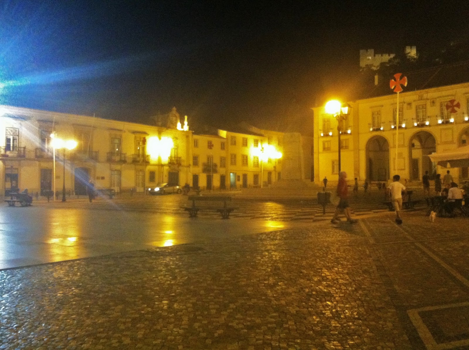
MT 9:19 PM – Tomar: Praça da República with City Hall on right (with Templar cross on pole in front of it) and Castelo de Tomar/Convento do Cristo on hill in background; barely visible in the center of the square is the statue of Gualdim Pais.
The 17th-century Paços do Conceilho (City Hall) is
located on Praça da República. The bronze statue in the square represents
Gualdim Pais, the 4th Grand Master of the Knights Templar, who founded the town
in the late 12th century.

9:17 PM – Tomar: view from Praça da República up
to Castelo de Tomar/Convento do Cristo on hill, with Templar cross on pole in
square.

MT 9:18 PM – Tomar: view from Praça da República
to E on Rua Serpa Pinto, back toward Restaurante Tabuleiro and Pensão
Residencial União.
No comments:
Post a Comment